
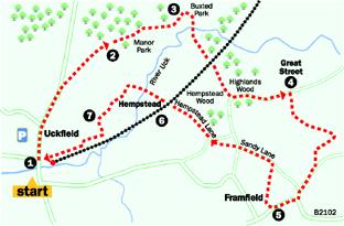
Starting and finishing at the rapidly expanding town of Uckfield, this walk heads north and east through a pleasant area of woodland managed by the Woodland Trust, before dropping down to cross the valley of the River Uck, passing en route through Buxted Park to reach the village of Framfield, where there is a conveniently placed pub.
After an initial ascent of Uckfield High Street, the walk follows a convenient segregated footpath through the urban fringe of the town. The return leg of the walk uses a newly created footpath, skirting to the south of a new housing estate and linking with a pleasant path through Hempstead Meadows, a local nature reserve.
1 Whether setting out from the car park or the railway station, start the walk northwards up the High Street. After a little over half a mile, soon after passing the start of a road called Southview Drive on the right, turn right along a tarmac path, labelled Tower Ride.
Go straight across an estate road, continuing with Tower Ride. Soon after crossing a second estate road, go ahead into woodland through a gap in a post and rail fence.
2 Follow the main path ahead through this attractive Woodland Trust area, ignoring side paths. From the far end of the wood, go ahead through a swing gate and along a wooden causeway.
Beyond this boardwalk, where the path divides, fork right, uphill. After leaving the wood, the path crosses rough pasture scattered with small trees, dropping down into the Uck valley.
Towards the bottom of the hill, go left through a wooden swing gate and on for a few yards to enter Buxted Park through a taller, metal, swing gate.
Go ahead, soon passing to the left of the first of a string of attractive ornamental ponds.
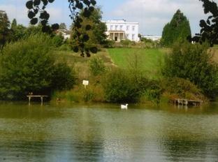
In view at the top of the hill to your left is Buxted Park House, built in 1726 but largely reconstructed after a fire in 1941.
3 Beyond the first pond, turn right over a wide bridge between two ponds, go ahead to a second bridge across the River Uck and, after a few yards, turn right at a finger-post.
A trodden path winds across tussocky grass to cross another footbridge and climb gently out of the valley. After leaving the park area through a second swing gate, follow a left-hand fence to a stile providing access to a railway crossing where elaborate steps take you down into a deep cutting and up the other side.
On the other side of the railway, go ahead, joining a clear track which soon follows a right field-edge. About 100 yards short of a gate leading out to a road, fork right along an unsigned path through a belt of woodland.
Shortly, disregarding a stile out of the wood, go ahead within the right wood edge to join a road and turn left.
4 After about a quarter of a mile, at the bottom of a hill, turn right over a stile and follow a path, now on part of the Wealdway, along a valley with a stream nearby on your left. Ignore the first signed path to the right.
After another quarter of a mile, just short of a footbridge, turn sharply back to the right, leaving the Wealdway to climb across pasture, aiming to pass to the right of farm buildings.
A few yards beyond the farm, at a footpath sign, turn left and climb across uneven ground to join a lane over a stile and turn right. Follow this lane, ignoring two roads to the right, out to a junction with the B2102, where you should turn right along the road into the village of Framfield as far as a telephone box.
5 If in need of refreshment, the village pub is now about 200 yards ahead along the road. For the return walk, just past the phone box, turn right through a small car park into Framfield recreation ground and go ahead along a drive with the play area to your right.
Where the drive ends, go forward over a stile and turn right across a field, diverging at about 20 degrees from the fence on your right. Skirt to the right of an enclosed, tree-shrouded pond to find a makeshift stile in a dip.
Climb along the right edge of the next field to reach a stile about 40 yards to the left of the right field corner. Continue across a paddock to join a lane and turn left.
At a crossroads, go ahead, signposted as Sandy Lane. At another road junction, turn right and, after a few yards, where the lane bends right, you should fork left along a wide path with picturesque tree-lined banks, marked as Hempstead Lane on the Explorer map.
After crossing the railway, the path acquires a metalled surface, soon crossing the River Uck next to Hempstead Mill. Follow the lane round to the left and, where it subsequently bends right, go ahead past a low concrete bollard and along a tarmac path.
Cross an estate road and continue past a metal barrier and along a wide enclosed path. Beyond another metal barrier go ahead along a lane.
After about 100 yards, turn left through a car park and drop down along the right edge of a recreation area. In the bottom right corner, turn right on a newly created path, part boardwalk, part hard gravel surface, which takes you along the valley and on with the railway nearby on your left through the Hempstead Meadows local nature reserve, emerging through a superstore car park to reach Uckfield High Street next to the railway and bus stations.
- Distance/Time: Six-and-a-quarter miles, taking three hours.
- By Car: Start from the town of Uckfield between Lewes and Tunbridge Wells. The large free town car park is signed westward from the High Street about halfway up the hill.
- By Public Transport: Bus from Brighton, Lewes or Tunbridge Wells. Train from the north via Oxted and Crowborough.
- What’s underfoot: A moderately hilly walk, all along good paths or lanes. The River Uck tends to flood after heavy rain.
- Thirsty Work: Pub at Framfield, about 200 yards off the route. All services at Uckfield.
- So you don’t get lost: OS Explorer map 135 and a compass for general direction.


Comments: Our rules
We want our comments to be a lively and valuable part of our community - a place where readers can debate and engage with the most important local issues. The ability to comment on our stories is a privilege, not a right, however, and that privilege may be withdrawn if it is abused or misused.
Please report any comments that break our rules.
Read the rules here