
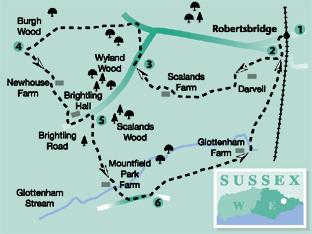
Ben Perkins continues his occasional series of walks from stations along the Hastings-to-Tunbridge Wells railway, this week starting out at Robertsbridge.
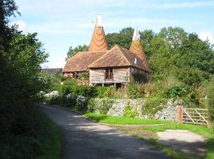
Heading west along a ridge on the southern slopes of the valley of the River Rother, the walk soon turns southwards to explore a varied mix of woodland and pastures, notable for hedgerows sprinkled with mature trees, before returning along the valley of the Glottenham Stream, a minor tributary of the Rother. En route are several houses converted from old oast houses, a reminder the area was once a centre for the hop industry, though hop fields are now few and far between.
1 From the entrance to Robertsbridge Station car park, turn right across the railway level crossing and, after 70 yards, turn left along Mill Rise. At the end of this cul-de-sac, go ahead along a short tarmac path to join a lane.
2 Go through a gap in railings on the other side of the lane a few yards to the right and follow a mown path which heads out across rough pasture, diverging gradually from the right field-edge.
On the other side of the field, descend steps, cross a tarmac drive and go ahead along a wide grass field headland with a conifer plantation on your left.
In the field corner, go through a gate and turn left along a wide fenced path. After a few yards, cross a concrete culvert and immediately turn right along an unmade track.
After passing between farm buildings, go ahead uphill now on a tarmac drive and, at a T-junction with another drive, turn right.
You are now walking close to Darvell Hall, a complex of buildings used as a TB sanatorium between 1920 and 1948 and, since 1971, home to an anabaptist Hutterite Community.
At another junction of tracks, go ahead, disregarding a signed path to the left. Shortly, ignoring another left fork, go forward through woodland. Pass through two iron swing gates in quick succession and walk ahead along the right edge of two fields.
In the second field corner, go right through an iron gate and gently downhill along a left field-edge. Cross a fenced track, using two gates, and veer slightly left across the next field to join a drive over a stile. Turn right to follow this drive out to a lane where you should turn right again.
3 After about 200 yards, go left over a stile without a step and head out across a field, walking parallel to the left edge to join a lane in the far left corner. Turn left.
After about 150 yards, turn left again through a swing gate, along a fenced path, then half-right across a meadow and down through woodland.
Leave the wood over a stile, bear right over a plank bridge, pass through a gate and then right over a more substantial footbridge. Now climb gently along the left edge of the next field.
In the field corner, cross a barway, or go through a wide gap to the left of it, and veer half left to drop downhill along the right edge of sloping pasture. At the bottom of the slope, go ahead along a raised bank for a short distance and on along the right edge of another field.
4 At the far end of this field, ignoring the inviting hedged path ahead, turn sharply left, staying within the same field and, passing about 40 yards to the left of a derelict stone cottage, descend to cross a footbridge.
Now bear left. Leave the trees, pass a few yards to the right of the end of a line of trees protruding from the left and continue diagonally uphill across a field.
Go over a stile a few yards to the left of the top field corner, forward though a rhododendron thicket and on along a fenced grassy path which skirts to the right of the twin converted oast at Newhouse Farm.
Join and follow the access drive from the property for 400 yards out to Brightling Road and turn left.
5 After about 250 yards, turn sharply right along an unmade track which soon burrows between wooded banks and subsequently between fences down through woodland.
After leaving the wood over a stile, maintain direction down across sloping pasture. You have a choice of gates ahead, yours is the nearer one.
Through the gate, veer half-left across the corner of a meadow to a stile and a short enclosed path skirting to the left of the large garden of the fine converted oast at Mountfield Park Farm.
Where the path opens out, turn right across a field corner, go over a footbridge, then left along an access drive out to Mountfield Road and turn left.
6 After about 250 yards, turn left through a gate and head half-right across a large field to find a stile a few yards to the right of the far field corner.
Turn right, round two sides of a plantation of young trees, cross a low sheep wire barrier and head squarely out across another large field.
Go over a stile beside a gate and forward along a fenced track. Follow this track which becomes an access drive past various buildings at Glottenham Farm.
After another two thirds of a mile, a few yards short of a bridge under the railway, fork left along an enclosed path. Beyond a footbridge, follow the right edge of rough pasture until you can join a road, back at point two.
Retrace your outgoing route to the start – along the path, almost opposite, forward along an estate road (Mill Rise) and right back to Robertsbridge Station.
- Distance/Time: Six miles, taking three hours.
- By car: Start from Robertsbridge, bypassed but accessible from the A21 about five miles north of Battle. Park in the station car park (fee payable) where the walk description starts (GR 734236) or in the village car park (GR 737236) and walk along Station Road to the station.
- By Public Transport: Train to Robertsbridge on the Hastings-to-Tunbridge Wells line. Hourly service.
- What's Underfoot: A moderately undulating route along generally clear woodland paths and across pasture where the paths are sometimes less well defined.
- Thirsty Work: Pub at Robertsbridge Station and in the village, a quarter of a mile off the route.
- So You Don't Get Lost: OS Explorer map124 and a compass for general direction.


Comments: Our rules
We want our comments to be a lively and valuable part of our community - a place where readers can debate and engage with the most important local issues. The ability to comment on our stories is a privilege, not a right, however, and that privilege may be withdrawn if it is abused or misused.
Please report any comments that break our rules.
Read the rules here