
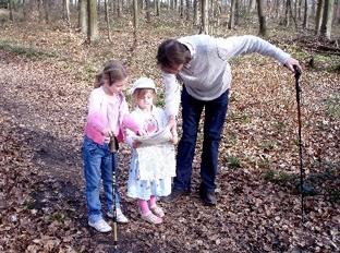
This shorter walk from Whiteways picnic area is an ideal downland outing for the adventurous young family keen to explore wide bridle paths, distant views and secluded woodland.
This walk by Eddie Start also provides an opportunity to become familiar with landscape features that are shown on the recommended Ordnance Survey map. The picnic area, at the start and finish, makes an ideal spot for a well-earned picnic at the end of the hike.
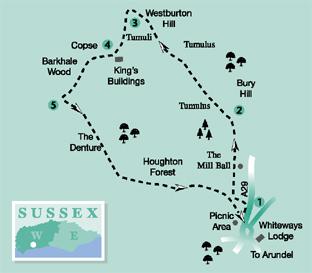
1 Walk to the top end of the Whiteways car parking area and take the signed bridleway, indicating that the South Downs Way is one mile away. Climb between the scrub to soon turn to the left and join the field-edge path, with beech woodland on the left and a wide, open field on the right.
Continue to the bottom left corner of the field and a path junction. Turn right and follow the rising bridleway across the area shown on the map as The Mill Ball.
This is the site of a bowl barrow dating from the period 2500–1400 BC. It will be a bumpy ride with a baby buggy across this section of the route. The path heads directly north for just over half-a-mile to arrive at a bridleway junction with the South Downs Way, just below the summit of Bury Hill.
2 Turn left on the South Downs Way, heading north-west on a rising path that begins to level off in a few hundred yards. There are extensive views from this high-level path as far as the coast and even the Isle of Wight.
The ancient landscape this part of the walk proceeds through has plenty of evidence of earlier civilizations. There are tumuli on either side of the track, possibly having associations with the Neolithic camp a short distance ahead, south of Bignor Hill.
In the past there would have been even greater evidence of such structures but sadly these have been lost beneath the plough. Along this balcony path is a good spot to introduce younger walkers to the mysteries of maps and some of the more obvious landscape features, maybe identifying landmarks such as the English Channel, the scattered tumuli and Downland buildings.
After half a mile the bridleway begins a slow descent around the flank of Westburton Hill, heading towards a distant cluster of large barns in the shallow coombe.
3 Just past the large storage barns on the right of the track and across a sometimes-muddy section, there is a confusing junction of five bridleways. Take a few paces to the left, beside some bushes. Do not take the South Downs Way route that climbs ahead, but turn to the left through a gate.
Climb the slow rise between downland bushes for 350 yards, passing through intermediate gates. On clearing the scrub cover walk ahead across the steeper, sloping meadow, passing through gate openings, with the green expanse of Houghton Forest off to the left.
In the unploughed fields it is possible to pick out the presence of the ancient burial mounds shown on the Ordnance Survey Explorer map.
The bridleway finally crests the hill, arriving at a field corner gate beside a track. Off to the left is the small animal enclosure of King’s Buildings that consists of a yard with a high flint wall and a barn, which may have provided shelter and temporary accommodation for a shepherd or herdsman.
4 Walk ahead on the track that passes to the left of a copse of Scots pine and then arrives at a field edge. Take a quarter-right line across the field, descending to the valley bottom and then climbing to the edge of woodland.
Enter the close, mixed woodland on a wide track, in a few yards veering to the half-left. The path now climbs more steeply into Barkhale Wood, soon levelling-off, and after 400 yards arrives at a crossing bridleway.
5 Turn left along the wide track in the area of Houghton Forest known as The Denture. The term denture was used to define a boundary between property, or territory, and so has its origins in the mists of legalese time; there are several occurrences of the term being used across the South Downs.
It may be necessary to reassure younger walkers on this expedition that the term denture used on the map does not refer to the items more senior members of the community may place into effervescing tumblers of pink liquid before going to bed!
Keep to the main track, sweeping gradually to the right after 300 yards. Take none of the inviting paths leading off to the right or left. After nearly three-quarters-of-a-mile there is an obvious fork in the track – take the left option.
The bridleway now begins a slow descent through the woodland, coming to a wide forest track in half-a-mile. Continue ahead for about 50 yards to a second track and turn right. The bridleway now climbs through close, mature beech woods for nearly half-a-mile to arrive back at the Whiteways car park. The grassed picnic area is off to the right, a short distance from the refreshment kiosk.
- DISTANCE/TIME: Four miles, taking approximately two to two-and-a-half hours
- BY CAR: The Whiteways car park is on the A29 road, three miles north of Arundel, west of the Whiteways roundabout at the junction with the A29. Start point Grid Ref. TQ002108.
- BY PUBLIC TRANSPORT: Details from www.traveline.info or phone 0871 2002233.
- WHAT’S UNDERFOOT: Downland walking across open hills and through close woodland, a couple of easy climbs. Possible with a baby backpack. Possible with a reliable, large-wheeled baby buggy but a bumpy ride in section one.
- THIRSTY WORK: Refreshment kiosk at Whiteways and a large picnic area at the site.
- SO YOU DON’T GET LOST: OS Explorer map 121.


Comments: Our rules
We want our comments to be a lively and valuable part of our community - a place where readers can debate and engage with the most important local issues. The ability to comment on our stories is a privilege, not a right, however, and that privilege may be withdrawn if it is abused or misused.
Please report any comments that break our rules.
Read the rules here