
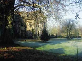
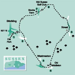
This walk by Ben Perkins is a pleasant and varied field path stroll, starting and finishing at Ditchling and visiting two small downland churches, at Westmeston and Streat, the latter situated on a low greensand ridge, offering a fine prospect from the churchyard southwards towards Ditchling Beacon.
Although generally well signed and waymarked thanks to the work of a group of local volunteers called the Monday Group, it is a fairly intricate route requiring careful navigation in places.
1 From the entrance to the Ditchling Village Hall car park turn right beside the B2116 road. After about 100 yards, fork left along a cul-de-sac called Fieldway which narrows to a path. Cross a road and continue along Farm Road, opposite. Shortly, go forward through a yellow gate and, after a few yards, turn right along the right edge of a recreation ground to rejoin the B2116.
2 Now follow a narrow path which starts almost opposite, signposted to Westmeston. Go obliquely across an estate road, continuing along a narrow path between houses.
Where the path opens out through a squeeze stile and you have a choice of two trodden parallel paths heading half right, yours is the one on the left which leads you across rough pasture and, well stiled, across three areas of young planted trees, then through a high gate in a deer fence and on with the fence on your right.
Once over a footbridge, veer slightly right across a field to a stile in the corner, then along the left edge of a paddock to a stile and, in the same direction across the field beyond.
3 In the field corner cross a house drive and follow a path along a raised bank above the B2116 road. Join and cross the road next to a bus stop and follow a path to and through Westmeston churchyard, passing to the left of the church and rejoining the road. Cross the road and turn left along another well segregated roadside path. Disregard the first signed path on the left and, after about 150 yards, turn left across the road to follow a signed bridleway which starts to the left of the gate to Old Middleton and soon turns away from the road.
4 Follow this tree-lined track, once an old droveway, northwards for two thirds of a mile. Ignore a crossing bridleway and, after another 200 yards, go right over a plank bridge and stile and follow a fenced path.
Where the enclosed path ends, head half-left across a rough area, until fairly recently a landfill site in an old sandpit, but now reverting to rough pasture. At a junction with a raised unfenced track, go left and where this track curves right, go left for a few yards to find a gap in a hedge and a swing gate.
Now head for Streat Church with a fence on your left, go over a stile and follow a trodden path gently up across the middle of a large field to another a swing gate.
Pass through a segment of churchyard and a wrought iron gate to join a track and turn right out to the lane at Streat.
5 Turn left to follow the lane where, for part of the distance, you can use a path along the top of the left roadside bank. After 400 yards along or beside the road, go left over a stile. Follow a left-hand fence for a few yards before heading out slightly left across a field to the next stile, in sight, then forward over another stile and squarely across the field beyond.
6 Pass through a bridle gate, then half-right across a field corner to a similar gate and on in the same direction through the next field. Cross a track, the northern extension of the droveway you used earlier, over two stiles, and head half-right across a field.
Go through a bridle gate, next to a farm gate and maintain direction across a field to a stile. Once over this stile and a plank bridge, bear left on a good path through an area of rough grass and scrub.
Pass to the right of the 17th tee of a golf course, forward for 60 yards to go through a squeeze stile and over a plank bridge. Now turn left along a path which passes about 30 yards to the left of the golf club house. Skirt to the left of a car park and continue through an untidy area used for dumping rubbish.
After less than 100 yards, look out for a narrow unmarked path to your right which winds through rough grass to a stile, then head half-left across a field to join a lane.
7 Start along the drive to Stocks Farm, opposite but, after ten yards, fork left over a stile and follow the direction of a waymark to reach a stile about 40 yards to the right of the far field corner.
Head squarely across the next field to a stile, once again near the far left corner. Follow the left edge of one more field until you can go left over a ladder stile, through trees to a gate and on with a high fence surrounding a free range chicken area on your left.
Pass through two more high gates providing access across the corner of the free range area, climb a low bank and bear half-right across another chicken area and through another high gate.
Cross a drive to a stile and head squarely across two fields with a stile between them and a fence on your left in the second field. Cross a stile a few yards to the right of the field corner and follow a fenced path between the ponds and enclosures of Stoneywish Park, home to some interesting wild fowl.
A clear path winds through scrub to join a drive where you should turn right, now retracing your outgoing route across a lane and along the path opposite, back to the start.
Distance/Time: Five miles / two and a quarter hours.
By Car: Start from the village of Ditchling. Park in the village car park behind the village hall on the south side of the B2116 road a few yards east of the cross-roads in the centre of the village (GR 328152).
By Public Transport: None practicable.
What’s underfoot: A walk without significant hills, along field paths and trackways. Be prepared for some mud underfoot after train.
Thirsty Work: Pubs and tea rooms in Ditchling, including Ditchling Museum’s Eat Your Cake Cafe. None elsewhere along the route.
So you don’t get lost: OS Explorer 122.


Comments: Our rules
We want our comments to be a lively and valuable part of our community - a place where readers can debate and engage with the most important local issues. The ability to comment on our stories is a privilege, not a right, however, and that privilege may be withdrawn if it is abused or misused.
Please report any comments that break our rules.
Read the rules here