
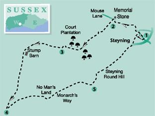
From the centre of delightful Steyning this walk by Eddie Start enters an apparently verminous lane to gain access to the high Downs. There are some challenging climbs and easygoing hilltop walking, with the resonance of the First World War along the way. The return is down the steep side of Steyning Round Hill to the village that celebrates St Cuthman.
1 - From the car park and bus stop at the mid-point of Steyning High Street, turn to the north-west (left as you leave the car park) and walk along the street, dropping to pass the fire station in 150 yards and Sir George’s Place, both on the left.
Continue along the now more level street to a sharp right road turning and turn left into Mouse Lane. Walk between the steep-sided lane for 100 yards, and immediately after Mouse Cottage turn left through a gap in the wall, then immediately turn right to cross a track to a stile leading into scrub. In a short distance cross into a level field organized into small paddocks and walk half-left to a marker post and then across the field beside the paddock fences, as indicated, to a gate at the far side.
Leave the paddock area over a stile beside the gate and, if the undergrowth permits, climb a bank and walk ahead between scrub to drop to a bridleway in 75 yards.
If the undergrowth is too dense, go to the half-right down the field access track for a short distance and then turn left onto the bridleway, passing around a metal field gate.
A short detour at this point, across Mouse Lane on the right, will take the observant walker to a granite stone set in the opposite bank. The stone poignantly recalls the words of a First World War soldier in the mud-filled trenches of Northern France, just before he heads off across No Man’s Land.
The words declare his wish to be back in Steyning, perhaps on part of the walk we are now setting out on, as we head towards a No Man’s Land on the Sussex Downs.
2 - Having turned left onto the bridleway, now begins the long climb onto the Downs.
The way is narrow, rutted and liable to be slippery after rain; it becomes progressively steep as it approaches Court Plantation. Continue on the path into the woodland, taking a half-right and in a few paces a half-left turn, just before a derelict structure (an obvious, more direct path line seems possible just before the right and left turns and soon re-joins the main path).
Climb for a further 300 yards on the increasingly steep woodland path, taking none of the side turnings, and take the right fork at a path junction, noting the blue arrows on marker posts.
After a climb totalling nearly three-quarters-of-a-mile the path begins a sweep to the right and a welcoming more level gradient.
Keep to the path, with a grassy bank and field on the left and woodland on the right. After 400 yards, at a field corner, turn left along a fenceline. Pass across the top of a field to arrive, after 100 yards, at the South Downs Way, above Steyning Valley.
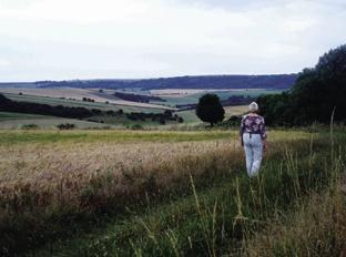
3 - Turn right along the wide bridleway, with the broad Downland landscape to the south and the English Channel beyond. Follow the Way for a quarter-of-a-mile to a fork in the track, and take the left branch on a bridleway that skirts around on the right of a Downland copse. The bridleway sweeps to the left around the copse and in a quarter-of- a-mile comes to a wider, crossing track, at the now derelict site of Stump Barn.
Turn left on the track and follow this for half-a-mile to pass between a more extensive Downland copse. Keep to the main track and in a further half-a-mile arrive at a junction of tracks, with the bulk of Cissbury Ring just over half-a-mile ahead, to the south.
4 - Turn sharp left at the first track that you come to at the junction, heading north-east and passing between arable fields and sweeping to the right, before descending towards the low-lying scrub and tree cover at No Mans Land.
There is a choice of paths to take as you approach the trees – all lead to the valley bottom and a junction of tracks, with advisory signs. Take the left turn onto the Monarch’s Way, leaving the low point of the valley and climbing steeply on a partially surfaced path. After half-a-mile of climbing the path levels-off, continuing between hedge and fence to a path junction beside a substantial memorial.
5 - Turn left, passing through a hedge opening, and immediately turn right on a bridleway path indicated by a sign that points to Steyning. The path passes around the top of Steyning Round Hill and descends to a path junction, with a seat to the left beneath a tree.
Turn right through a gate and follow the descending path, taking the left option at a junction and descending more steeply towards the woodland at the foot of the slope.
The path passes to the left of a former quarry and continues more steeply beneath trees for 150 yards to arrive at a gate, leading to a minor road. Follow the road towards the houses at the edge of Steyning and continue along a residential road for a further 250 yards.
Locate a footpath on the left, between bungalows, climb up the path and follow it to the right behind a garden fence to the edge of a recreation ground. Take a half-left line across the parkland, aiming for the far left corner, just after some tennis courts.
Pass between houses to a residential road and turn right. Walk along the street and in 200 yards cross to the rear entrance of the village car park, where this walk began.
* DISTANCE/TIME: Five-and-a-half miles taking two-and-three-quarter hours.
* BY CAR: Leave the A283 road and head for the High Street in Steyning and the village centre car park, on the west of the street. Start point Grid Ref. TQ176112
* BY PUBLIC TRANSPORT: Bus details from www.traveline.info or phone 0871 200 22 33. Bus stop in the High Street, next to the car park.
* WHAT’S UNDERFOOT: Downland walking from Steyning centre, with two steep climbs and one steep, and after rain, slippery descent. Possible with a baby backpack but tough going on the climbs; not possible with a baby buggy.
* THIRSTY WORK: Pubs and teashops in Steyning High Street.
* SO YOU DON’T GET LOST: OS Explorer maps 121 and 122, plus a compass for general direction.


Comments: Our rules
We want our comments to be a lively and valuable part of our community - a place where readers can debate and engage with the most important local issues. The ability to comment on our stories is a privilege, not a right, however, and that privilege may be withdrawn if it is abused or misused.
Please report any comments that break our rules.
Read the rules here