
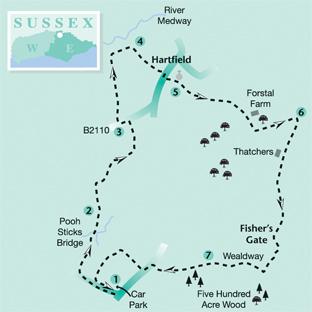
This walk by Ben Perkins on the northern edge of Ashdown Forest follows a well-trodden route to Poohsticks Bridge before continuing to the village of Hartfield.
The return journey passes through the picturesque fringe of Five Hundred Acre Wood, another name familiar to readers of A A Milne’s Winnie-the-Pooh stories
1 - From the corner of the Pooh Bridge car park, follow the well-trodden path signed to Pooh Bridge. After about 400 yards, join a lane, go forward for 60 yards and then turn right along a wide track.
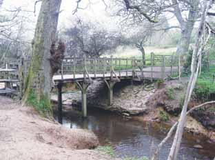
Follow this track downhill for almost half a mile to reach and cross Poohsticks Bridge. Continue along the path to join and follow a tarmac drive.
2 - After a few yards, at a Y-junction, keep left and shortly fork right over a stile beside a gate. Go ahead across a meadow to another stile from which a trodden path continues across the middle of rough pasture to a third stile.
Cross a drive, go through the swing gate opposite and follow a fenced path ahead. After about 250 yards, look out for a bridle gate on your left and a path which passes a pond and winds through a plantation of young trees.
Carry on along the left edge of a horse paddock to join the B2110 road and turn left.
3 - After about 100 yards, turn right along the access drive to Culver Farm which, once beyond the farm buildings, becomes a wide grassy path between fences.
Continue through a wood, across a low-lying pasture and up steps to join the track bed of the old railway, now converted to the Forest Way, where you should turn right.
4 - After about 200 yards, go right over a stile and follow a clear signed path through two fields and along the right edge of a recreation ground out to the road at Hartfield.
From stage four to stage six you will be following part of the well-signed High Weald Landscape Trail, a 90-mile, well way-marked route linking Horsham with Rye.
Turn right and, after a few yards, turn left along Church Street, passing the Anchor Inn on your left. A little further along the lane, you will pass the entrance to Hartfield Church where the lych gate is covered by the upper story of a small half-timbered house dating from 1520.
5 - When opposite the church itself on your left, turn right up steps and over a stile and go left along the left edge of two fields with a concrete bridge and stile between them.
Once over a stile in the second field corner, follow a trodden path across a large field to a waypost where the path passes through a scanty line of mature oak trees.
Continue to the far left corner.
Go through a gap, forward along a sandy track to pass through another gap and then follow a clear grassy headland track along a left field-edge.
In the field corner, cross a substantial brick bridge over one of the main feeder streams of the River Medway and immediately turn left along a woodland path.
After leaving the wood, go ahead on a trodden route across old park land which brings you out on to a metalled drive.
6 - Turn right here, parting company with the High Weald Landscape Trail and joining the Wealdway. Follow the drive southwards with good views opening up ahead towards Ashdown Forest.
After the best part of a mile, at Fisher’s Gate, just short of a house entrance, turn left over a stile and follow a right-hand fence as it skirts to the left of house and garden. Rejoin a drive as it passes to the right of a recently excavated pond.
Just past the pond, ignore a left fork and, after a few yards, turn right at a T-junction. Disregard another left fork, keeping on the main drive and the waymarked Wealdway.
At another junction, stick to the main drive as it continues within the southern fringe of Five Hundred Acre Wood.
After passing to the left of the high gateway to Kovacs Lodge, the drive becomes an unmade track.
7 - Where the Wealdway is signed to the left, on its way up and over Ashdown Forest, leave it to go ahead, still on a clear track. A few yards beyond a footbridge, fork right, steeply up and on to join the B2026 road where you should turn left along the narrow but usable grass verge.
After 150 yards turn right over a stile and head half right across a sandy equestrian arena where gaps have been left in the perimeter fence. Over another stile, go ahead along a wide track.
After 200 yards, turn left along a fenced headland path. From a stile in the corner go ahead into a wood.
Shortly bear left along a gravel track and, after 30 yards, fork right through a bridle gate and ahead with a post and rail fence on your right, adorned with a series of aggressive labels warning of guard dogs.
A few yards after this fence ends, fork right through a swing gate, cross a meadow to pass through a similar gate and then go forward through the wood for 50 yards to rejoin the well-worn route to Pooh Bridge, used at the start of the walk. Turn left, retracing your steps to the car park.
* Distance/Time: Six and a half miles, taking three hours.
* By Car: From the B2026 road about two miles south of Hartfield, turn east along Chuck Hatch Lane and park in the Pooh Bridge Car Park about 100 yards along the lane on the right at GR 473331.
* By Public Transport: There are hourly weekday buses from Tunbridge Wells or Crawley to Hartfield, joining the walk between points four and five.
* What’s underfoot: A walk along well-established and mostly well-signed paths and tracks. Minor ups and downs only. May be muddy in one or two spots after rain.
* Thirsty Work: Two pubs at Hartfield between stages four and five.
* So you don’t get lost: OS Explorer 135.


Comments: Our rules
We want our comments to be a lively and valuable part of our community - a place where readers can debate and engage with the most important local issues. The ability to comment on our stories is a privilege, not a right, however, and that privilege may be withdrawn if it is abused or misused.
Please report any comments that break our rules.
Read the rules here