

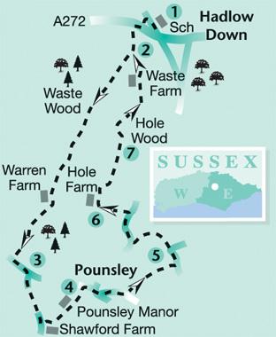
1 - Leaving Hadlow Down school on your left, follow the road away from the A272 and shortly turn left along a drive, signed to the church and burial ground.
Pass between brick gate posts and a wrought-iron gate, then walk round the edge of the burial ground to reach the A272 through a swing gate.
Cross the main road, turn right along the opposite pavement for a few yards and then turn left along the access drive to Woodlands Farm.
2 - After about 250 yards, just short of a gate, fork right along a shady track which you can now follow for more than a mile southwards through Waste Wood. It can be muddy underfoot in places but the worst of the mud can be avoided by using alternative parallel paths which walkers have established along the adjoining bank.
Where the path eventually opens out, go ahead, passing to the left of the buildings at Warren Farm. Continue along the unmade access track from the property for another quarter of a mile out to a lane where you should turn left.
3 - After about 200 yards, turn right along Gun Road, signposted to Blackboys. After another quarter of a mile, just short of a large house (Shawford Farm), turn left along a drive following it as it passes to the right of a remote youth hostel. Go through a gate with a “No Parking” notice on it and follow the track ahead as it soon curves left through woodland.
Leave the wood over a stile and continue along a right field-edge, and then a rather overgrown path which skirts to the left of the house and grounds of Pounsley Manor. Join an access drive which takes you out to a lane where you should turn right.
4 - At a road junction, go straight ahead and, after a few yards, fork left along Sharlands Lane. After about 200 yards, just past the last house on the left (Pounsley Mill Farm), turn left through a gate to follow a fenced dirt track.
Where this track peters out, go ahead along a field-edge, skirting to the right of a small enclosure to cross an awkwardly barricaded stile in a dip.
Go forward along a left field-edge for 40 yards, side-step to the left through a gap, then resume your previous direction, now with a hedge on your right.
Go through a gate next to a power pole and climb gently, still with a hedge on your right, until you can go over a stile in this hedge. Cross the next field, walking roughly parallel to minor power lines to join a lane over a stile beside a gate and turn left.
5 - At a road junction go straight ahead along Riverside and at the next road junction turn right, signposted to Hadlow Down.
About 70 yards after passing the start of the drive to Hole Farm on your left, turn left up steps and along a path within the right edge of woodland which eventually joins the drive to Hole Farm. Turn right along the drive.
6 - Just past a small pond on your right, where the drive divides, keep left and, immediately, at a finger post, turn right to contour along a grassy bank. Squeeze to the right of the corner of an equestrian exercise area and go forward with a hedge on your right.
Shortly cross a drive and go ahead within a wide grassy strip, skirting to the left of a large house and garden and curving gently right.
Just short of the point where the track enters woodland, veer left to climb along the right edge of a large area of pasture with a wood on your right.
7 - About halfway up the field, turn right over a stile into the wood and then left, resuming your previous direction, now within the left wood-edge.
At a junction of paths go ahead, still inside the wood. Emerging from the wood, go forward along the right edge of a meadow. Shortly, in the field corner, bear right on a clear path through trees which, after 60 yards, emerges into another field.
Follow a faintly trodden path across the middle of this large field. About 30 yards short of the top left corner, re-enter woodland and follow a clear path through trees and on across another field where the path is indicated by a waypost.
A track continues, skirting to the right of the house and garden at Woodlands Farm, marked as Waste Farm on the OS map. Back at point two, retrace your outgoing route to the start, along the drive to the A272, then right and left through the churchyard.
- If you’d like a longer outing, this walk can be linked without overlap with the walk, also starting and finishing at Hadlow Down, published in the Argus on April 19, 2008, and available on the website, adding up to a combined figure-of-eight totalling just under 11 miles.
* DISTANCE/TIME: Five miles taking two and a half hours.
* BY CAR: Start from Hadlow Down on the A272, about two miles east of Buxted. Roadside parking is possible in the vicinity of the church and village school along a lane which heads north-west from the A272 at GR 531241.
* BY PUBLIC TRANSPORT: None practicable.
* WHAT’S UNDERFOOT: A gently undulating walk along field and woodland paths and quiet country lanes.
* THIRSTY WORK: No refreshments on the walk.
* SO YOU DON’T GET LOST: OS Explorer map 135.


Comments: Our rules
We want our comments to be a lively and valuable part of our community - a place where readers can debate and engage with the most important local issues. The ability to comment on our stories is a privilege, not a right, however, and that privilege may be withdrawn if it is abused or misused.
Please report any comments that break our rules.
Read the rules here