
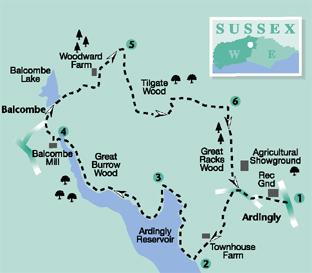
1 - From the entrance of the recreation ground in Ardingly, walk across the small car park, keeping to the left hedgerow and passing behind the sports pavilion. Follow the footpath as it passes beside a playground and behind houses. Continue over the park to join Street Lane, a minor road, and turn right.
Walk along the road to a junction beside the village church of St Peter’s, taking the left fork into Church Lane.
Follow the quiet, metalled lane, between secluded residences, for 250 yards and continue on the rougher track, as it turns right, to arrive beside the buildings of Townhouse Farm. From the four-way marker post take the centre, half-left path, through a hedge opening, with metal gates, and descend for 400 yards to the shoreside path at Ardingly Reservoir.
2 - Turn right on the path, the Kingfisher Trail, and follow it around the shoreline of the reservoir.
The reservoir was created in 1978 to capture the waters of the River Ouse. It covers an area of 198 acres and provides drinking water for this part of Sussex. The site is operated by South East Water.
The path follows a winding route, with lake access at several places for anglers and bird watchers. Keep to the rise and fall of the main path for a little over half a mile, passing a number of information boards on the way. The path finally climbs to the right to arrive at the roadside. Turn left down the minor road, crossing a causeway over the reservoir, to the far side and a bridle gate on the left.
3 - Turn left, through the gate on to a bridleway. The trail now follows the shoreline of the reservoir, along one of its upper stretches, for about one mile. As this is a bridleway, walkers may encounter some muddy sections due to the horse and mountain bike traffic.
The route is obvious and no side turnings should be taken. There are the familiar angling and bird-watching sites leading off the path to the waterside. As the head of the reservoir is reached, through Great Burrow Wood, the path climbs to the roadside.
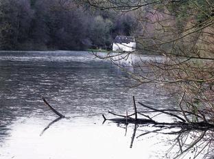
Turn left down the road, soon drawing alongside the distinctive clapperboard Balcombe Mill House, with the adjacent water-channelling structures that would have directed the flow when the mill was a functioning operation.
4 - Pass by the building to where the road turns sharply to the right. Locate on the left a flight of rustic steps and climb the steep bank, through woodland. At the top of the steps, pass through a gate and walk to the right for few paces along the fenceline.
Turn right through a bridle gate and descend the path through woodland, going left after a few yards and then veering right, to climb to the roadside.
Turn left up the road for 75 yards to where it turns sharply left and take the descending surfaced footpath on the right. Do not be deterred from taking this path by the adjacent sign cautioning restricted access to those using satellite navigation (gps) equipment; this is a public footpath.
Follow the path for 300 yards and pass over the retaining dam wall of Balcombe Lake. Keep to the metalled track and climb from the lake for 400 yards to a sharp left turn.
Just after the turn cross a stile on the right, beside a metal gate, and follow the left hedgeline to the left field corner. Turn left from the corner over a stile, climbing up the field ahead, passing to the right of buildings at Woodward’s Farm. When opposite the buildings, take the middle of three metal gates on the right and climb to the top of the hill, to arrive beside farm buildings. Walk ahead, going quarter-right, along the farm drive and coming to the roadside in 100 yards.
5 - Turn right along the quiet road, which follows one of the High Weald ridges, for half a mile.
As the road begins a gradual descent note a small lay-by on the left, at the edge of Tilgate Wood – there is a holly tree over-arching the road at this point. Turn left here into Tilgate Wood on a descending footpath. (At the time this walk was surveyed, the footpath sign at the turn-off had been damaged and was not in place.) Follow the twisting, sometimes slippery, path down through the woodland for 400 yards and, as the edge of the reservoir comes into view, go left and then right, finally crossing the substantial footbridge. At the far side of the bridge climb to the left and follow the track to a gate at the edge of the Wakehurst estate. Note the bridle gate on the right and go through this, climbing up the left fence line towards Tillinghurst Farm. Keep to the left of the farm buildings, continuing for 250 yards on a surfaced driveway.
6 - On coming to a path junction, with the Ardingly Showground off to the right, turn right on a footpath that keeps right of the main showground boundary. Descend towards and pass along the edge of Great Racks Wood. On leaving the woodland, climb to join a metalled track beside the perimeter fence of the showground and continue in a southerly direction. After one third of a mile, as the track turns left, at the end of the site, note a bridle gate on the right and turn off through this.
On arriving at a minor road, Street Lane, turn left along the pavement and after 250 yards go left on to the footpath we used earlier, at the start of the walk. Follow the path across the recreation ground, back to the starting point and car park.
* Distance/Time: Seven miles taking three-and-a-half hours. .
* By Car: Car parking in the recreation ground at the northern edge of Ardingly. Start point Grid Ref. TQ347297 * By Public Transport: Bus details from www.traveline.info, phone 0871 2002233. Bus stop in Ardingly village, no Sunday service.
* What’s underfoot: High Weald walking with some climbs and muddy descents. Possible with a baby backpack, could be tricky on steep sections and it is quite a long way; not possible with a baby buggy.
* Thirsty Work: Pubs and teashop in Ardingly.
* So you don’t get lost: OS Explorer map 135 plus a compass for general direction.


Comments: Our rules
We want our comments to be a lively and valuable part of our community - a place where readers can debate and engage with the most important local issues. The ability to comment on our stories is a privilege, not a right, however, and that privilege may be withdrawn if it is abused or misused.
Please report any comments that break our rules.
Read the rules here