
This shorter, easygoing flatlands walk by Eddie Start, is in the quiet countryside of mature farms and isolated dwellings that are typical of the Low Weald. There are no challenges or steep ascents, just relaxing country paths and the ghostly puffing of long-gone trains from long-lost eras.
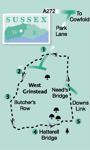
1 - Locate the footpath on the west side of Park Lane, 450 yards north of the junction with the B2135 at West Grinstead and south of the A272. Follow the path to cross a stile at a field edge and turn left along the hedgerow, at the edge of West Grinstead Park, to the left corner of the field. From the corner, go right and in 75 yards turn left through a wide hedge opening. Skirt around a copse, which is on the right, with a field on the left, and when beside the first of several tall Scots Pines, strike off half-left, across the field. Take a line that leads to the mid-point of the opposite hedgerow, beside a road. Locate a stile in the hedge and cross the road, with care, to the opposite lane, arriving beside a small, white clapperboard cottage.
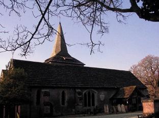
2 - Follow the lane over a short rise and at fork, after 200 yards, take the right branch that leads towards Glebe House. On approaching the entrance to the house the driveway goes sharply right, take this turning that leads to the car park beside the parish church of St George.
A brief detour into the church is instructive of how social structures used to be organised – the front pews are named for local worthies who could afford such exclusive privileges. Presumably the hoi polloi sat at the back in their humble, sinful anonymity.
On leaving the church, note the Saxon, herringbone pattern, sandstone work on the wall adjacent to the ancient porch, an indication that a place of gathering and worship has been at this site for many centuries. Return to the path and walk through the churchyard, keeping left of the church and branching half-left to a kissing gate. Pass through the gate and follow a flagstone causeway path, crossing a bridge and diverting left to a field corner pedestrian gate.
Turn right up the driveway at Butcher’s Row, passing local houses and at a fork by Fosters Farm Cottage, after 75 yards, take the right branch on the surfaced drive.
3 - Continue for 150 yards to a five-way path junction and turn quarter-left along a tree-lined footpath. In 200 yards, and just after a left bend in the path, locate a stile in the fence on the left. Do not continue on the main track, which turns to the half-right. Cross left into a field, walking ahead to cross a mid-field drainage stream, in 75 yards. Turn half-right, passing beside a line of oak trees, and heading towards a stile in a rail fence at the left field corner. Enter a small woodland and walk ahead along the edge of the woods, up a wide track, for 150 yards, to arrive at a three-way path sign, adjacent to a field. Turn left along the field edge for 125 yards, going over a wider track and crossing a plank bridge and stile. In the next field walk ahead, with a line of trees on the left, to a field corner and junction of paths, go through the facing metal gate. Do not take the optional left turn.
4 - Walk down a field edge to the bottom right corner and turn left for 50 yards to draw alongside a pond and small reed bed. Turn right on the footpath next to the pond, passing through a gate, and heading beside a drainage gully, towards the field-centre Hattrell Bridge, that crosses a tributary of the River Adur. Cross the bridge and control weir, passing through two metal gates, and walk ahead towards a gate at the edge of the opposite woodland. Climb up through the woodland on a track to arrive at the edge of a field. Follow the trodden path across the middle of the field towards a distant bridle gate. Pass through the gate and continue along the left hedgeline, going through a further gate and descending to the Downs Link path.
5 - Turn left on the wide, level path, which was once the route of the Horsham to Shoreham-by-Sea railway and is now a long-distance path between Surrey and the Sussex coast. Follow the track for half-a-mile to cross over Needs Bridge and continue, heading north. Pass two separate footpath signs, after crossing the bridge – one in 100 yards and the second in a quarter-of-a-mile. On coming to a third sign, half-a-mile after Needs Bridge, turn left, descending steps to a field edge. Walk along the field-side path, with a drainage ditch on the right, skirting around a copse and descending to cross a stile and plank bridge. Climb out from the gully and turn left on an enclosed path, turning right after a few paces, crossing a midway plank bridge and climbing to a stile at the roadside.
Turn left down the road, coming to the starting point and lay-by parking verge.
A few hundred yards south of the starting point of this walk, at the junction with the B2135 road, is the local Roman Catholic church, the final resting place of Hilaire Belloc, the writer, poet and politician, who lived at nearby Shipley and famously extolled the spirit of Sussex.
* Distance/ Time: Four miles/two hours
* By Car: Verge parking on the minor road between the A272 and the B2135. Start point Grid Ref. TQ178215.
* By Public Transport: Bus details from www.traveline.info, phone 0871 200 2233. No bus stop at the start of walk.
* What’s underfoot: This route is mostly level walking on well-defined paths, possible with a baby backpack; not possible with a baby buggy.
* Thirsty Work: There are no refreshment stops on this walk unfortunately, so bring a picnic.
* So you don’t get lost: OS Explorer maps 122 and 134, plus a compass for general direction.


Comments: Our rules
We want our comments to be a lively and valuable part of our community - a place where readers can debate and engage with the most important local issues. The ability to comment on our stories is a privilege, not a right, however, and that privilege may be withdrawn if it is abused or misused.
Please report any comments that break our rules.
Read the rules here