
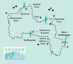
1. From the parking area beside the church of St Mary, enter the churchyard, following the descending path, and going right of the church. At the bottom of the churchyard, turn right through a gate, continuing beside a wall. In 100 yards, at a junction of paths, turn left. Follow the rising path across the top of a rise beside paddocks. Keep to the path, at first behind houses, ignoring a left turn in 200 yards and crossing a stile. Continue ahead to a second path junction, take a few paces left and descend a short ramp to turn right. On approaching a converted windmill, follow the path to the roadside. Cross the road with care, turning left into Stream Lane and in a few yards turn right up steps. The path continues across a garden, beside a high hedge, with an ornamental pond on the left. In 100 yards locate a stile in the facing fence, crossing a gravel drive and entering the next field, then turning right to the top right corner stile.
Go half-left across a golf course, through a clump of trees, to the left corner, descending to a minor road.
2. Turn right up the road, passing Dennis Marcus Farm, on the right. Continue for about 50 yards and, on arriving at Stile Farm Cottage on the left, turn left up a gravel drive, passing through a gate into Nutbourne vineyard. Keep to the path and after one-third-of-a-mile descend right in front of a sandstone mill house and forecourt.
Go right and after a few yards, just after a timber outhouse, turn left up a driveway.
(Take neither the signed footpath beside the mill house, nor the one heading north.) Walk up the drive, with the millpond on the right, to the roadside in Nutbourne. (Ignore the footpath on the right, at the top of the drive.)
3. At the roadside, take a few paces right, turning left on to a gravel drive, beside a house called The Camber. Walk to an enclosed path, in a right corner, leading to a deer gate. Proceed ahead along a left fenceline, with vines on the right. At a fence corner, turn left, to the next corner. Turn right and in 150 yards pass through a deer gate, cross a stile and climb beside hedgerow for 50 yards. At a four-way sign cross the stile on the right. Go quarter-right in the next meadow, descending to a stile, beside a stable. Walk ahead for a few yards to a driveway, turn left, passing a thatched cottage and climbing right, up a drive. On arriving at a surfaced road, turn right, taking a left fork in a few yards and passing a house called West Mare.
In a few paces climb right up a bank, beside an oak tree, to cross a stile. Walk towards a marker post, turning left to the field corner and then right, up the hedgerow, to a kissing gate. Climb the enclosed footpath to a three-way sign at the top of the field and turn left. In a few yards, turn right towards Broomershill Farm.
4. From the surfaced driveway, in front of the farmhouse, turn right, beside a metal rail fence, and go left down the drive. In a few yards divert right, through a small metal gate, and walk around the bottom of an embankment. At a three-way sign, take the right branch, crossing a stile and climbing the field to the top right corner, to cross a stile. Go quarter-left to a stile, turning left along a field edge, and going through a gate in 250 yards. Follow a half-left line across the field, descending to cross a stile beside an oak tree. Continue up the fence line, with reservoirs on the right, pass through a gate and descend right to a road.
5. Cross the road and follow the driveway to Redfold Farm. On approaching the farm, note a five-bar gate on the right and cross the stile next to it. Take the descending grassy ramp across the field towards the bottom right corner. Pass through a gate, then over a stream bridge and across a stile. Climb ahead up the next field to cross a right corner stile. Go over a track, on to a higher-level, enclosed path, walk between scrub, above a meadow, to a three- way path junction beside a large holly tree. Turn left down a gully path, soon veering right, with a large pond on the left. The path goes left across the end of the pond, crosses a bridge and climbs steeply through woodland. At the top of the climb, walk ahead on a driveway, passing right of a cottage, to a minor road. Climb the opposite steps and turn left along the edge of a vineyard. In 50 yards turn right down the edge of the field, diverting left in 150 yards to an access drive that descends towards buildings at Nyetimber.
Walk over a yard to a crossing bridleway track and turn right.
6. In 250 yards turn left on the bridleway, going right down a sandstone gully path in 150 yards.
The path arrives at a junction adjacent to a golf course, take a line climbing ahead to the top of a grassy slope. Follow the descending bridleway for 250 yards, between an avenue of trees, to a three-way sign and turn left across the fairway. At the top of the rise, pass around a wooden gate and go ahead on a gully path, climbing for 200 yards. As the path levels-off, turn right down a driveway leading to a minor road.
Go left towards the centre of West Chiltington, turning right beside the post office, into Church Street, back towards our starting point.
***
Distance/time: Six-and-a-quarter miles taking three hours.
By car: Small car park in Church Street, West Chiltington, in front of St Mary’s Church, additional parking as signed.
Start point Grid Ref. TQ090184.
By public transport: Buses stop in main village street, turn into Church Street and walk 200 yards to start point.
Bus details from www.traveline.info, or 0871 200 22 33.
What’s underfoot: Up and down Wealden walking with a couple of steep climbs; possible with a baby backpack, not possible with a baby buggy.
Thirsty Work: The Queen’s Head pub in West Chiltington.
So you don’t get lost: OS Explorer maps 121, plus a compass for general direction.


Comments: Our rules
We want our comments to be a lively and valuable part of our community - a place where readers can debate and engage with the most important local issues. The ability to comment on our stories is a privilege, not a right, however, and that privilege may be withdrawn if it is abused or misused.
Please report any comments that break our rules.
Read the rules here