
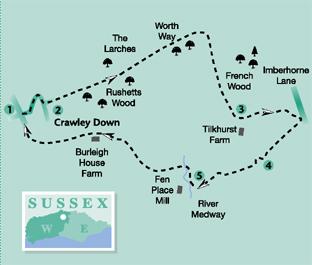
A High Weald walk, by Eddie Start, from the village of Crawley Down out into the surrounding countryside, using a former railway line and following quiet, country paths that pass by a water source, whose outlet is a long-way off, in another county.
1 - From the centre of Crawley Down, beside the local shopping parade, Royal Oak pub and the bus stop, turn into Burleigh Way, noting the signs for the Worth Way.
In the past Crawley Down was a centre for the Wealden iron industry and, later, brick making. Now it is a very pleasant residential village with a thriving community.
Follow the road as it bends left between houses and on arriving at Woodland Drive, turn right into this residential road. Climb for 75 yards and turn left into Hazel Way. Keep to the pavement in this quiet residential road and after about a quarter-of-a-mile turn right into Cob Close. At the far side of the close pass around an entrance gate on to the Worth Way track. This route follows the line of the former High Weald railway, from Three Bridges through to East Grinstead, and is now designated as a right- of-way and cycle route.
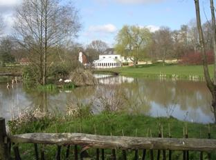
2 - Keep to the raised embankment, passing the Crawley Down Pond after a few yards and continuing ahead between Rushetts Wood and The Larches. With occasional glimpses through the trees to surrounding farmland, the easy walking on this former track way begins a slow rise to a four-way path junction in three-quarters-of-a-mile. There are a couple dark, murky woodland pools at the trackside. Turn right, going south through a metal kissing gate and along a field-edge path. After 75 yards the path leaves the field edge and maintains direction, climbing ahead across the field to a footpath sign in the opposite hedgerow opening. Continue across the next field, going quarter-left and passing a mid-way pond that is on the left. Head for the opening between trees at the edge of French Wood and then keep to the wider track across a further field, towards a third hedgerow-opening and a three-way path junction.
3 - With the buildings of Tilkhurst Farm 150 yards ahead, immediately turn left up the signed woodland-edge footpath. Cross over a concreted farm track and climb to the top of the hill, passing right, round a clump of trees – there is a distinctive white villa and a water tower off to the left. Walk to a stile, a few yards ahead, beyond the trees, following the path through a narrow strip of woodland and going to the right on an enclosed section, to the edge of Imberhorne Lane. Cross a stile on the right, just short of the roadside, walk ahead a few paces and take a right turn. Follow an indistinct path across the field, keeping about 50 yards to the right of a field-centre power cable post. Maintain direction across the top of a low rise, descending in the next part of the field and passing a woodland corner that is away to the left. Keep to a line that heads towards the far, right corner of the field, a total distance of one-third-of-a-mile.
4 - Go right through a hedgerow opening and in a few paces turn left over a plank bridge, beside a pond. Walk ahead through the scrub to a field edge and turn right. Walk ahead for about 100 yards and strike off left across the field, to a hedge opening. Cross a plank bridge and stile in the hedge and continue across the next field, as signed, to the far side.
5 - Turn right along a left hedge for a few yards and then turn left through an opening. Walk down the next field, with scrub and trees on the left, to the bottom left corner and descend left. At the bottom of the slope turn right over a stile, go ahead a few paces and turn right along the edge of scrub cover. Keep to the signed path through the scrub, coming to a three-way sign beside a stile in 100 yards. Cross into the next field and immediately turn left, soon crossing a bridge, to arrive in a clearing, in front of fencing close to Fen Place Mill.
(From this point the footpath route differs from that shown on earlier copies of the OS Explorer map. If you have the latest version of the map the route is identified, and is as indicated in the following instructions.) Turn right along the wide footpath, with a stream, the nascent River Medway, on the right, on its way to an estuary in Kent. In 150 yards, at a fence and field corner, turn left on a rising, tree-lined path. At the top of the climb the path passes between bordering trees and turns right. Follow a wide, twisting route, soon passing a hilltop pool on the right. Continue to a field corner and three-way path junction, with a kissing gate in the right hedgeline. Pass through the gate and take a line directly ahead, up the wide field. Climb for 350 yards to the top of the field, passing through a gate and turning left on the Sussex Border Path. Keep to the left edge, climbing to the top of the hill and stile beside Burleigh House Farm. Cross to a surfaced driveway and turn right. Follow the drive, passing some partial development and secluded dwellings, along Burleigh Lane.
The road comes to the edge of Crawley Down, after one-third-of-mile, and sweeps to the right, descending back to the village centre, close to the starting point.
* Distance/Time: Five miles taking two-and-a-half hours.
* By Car: Village car park at beginning of Burleigh Way, opposite shops. Start point Grid Ref. TQ347375.
* By Public Transport: Metrobuses stop in Burleigh Way, opposite shops. Bus details from www.traveline.info, phone 0871 200 2233.
* What’s underfoot: Easy-going High Weald walking with no difficulties; possible with a baby backpack, not possible with a baby buggy.
* Thirsty Work: The Royal Oak pub in the village centre.
* So you don’t get lost: OS Explorer maps 135, plus a compass for general direction.


Comments: Our rules
We want our comments to be a lively and valuable part of our community - a place where readers can debate and engage with the most important local issues. The ability to comment on our stories is a privilege, not a right, however, and that privilege may be withdrawn if it is abused or misused.
Please report any comments that break our rules.
Read the rules here