
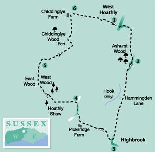
1 - From the centre of West Hoathly turn into Church Hill, between the church gate of St Margaret of Antioch and with The Cat pub on the left.
Walk down the roadside, following an S-bend, then climbing between high banks for 200 yards to cross a hedgerow stile on the right. Descend steeply across a small meadow, heading for a kissing gate in a little more than 100 yards, leading into scrub and low trees.
Follow the path above a wooded bank that slopes to the right. After 150 yards the path leaves the cover, going over a stile and along the meadow edge beside Ashurst Wood. At the right field corner, pass through a gate and skirt around the edge of a garden, turning sharp left on an enclosed path, up to the roadside.
2 - Turn right along Hammingden Lane, following a high ridge route southward. There are plenty of opportunities to look through hedgerow on either side of the quiet road, with extensive views east across the Weald as it rises and falls under a sylvan canopy. To the right a steep-sided slope of meadows and woodland dip to Hook Ghyl on its sinuous journey to join the River Ouse. Along the way there are sandstone boulders at the side of the road, a reminder that this landscape is much older that the distant South Downs.
Eventually the spire of All Saints church at the tiny community of Highbrook comes into view and after passing the few houses in the hamlet, just before a telephone box and a left turn in the road, opposite a Royal Mail post box, turn right on to a footpath through a farmyard.
3 - Walk ahead between buildings and at a junction of tracks branch quarter-right, through a metal gate.
Descend a track, passing through a second gate after 100 yards. Immediately after the gate leaves the track, go left down a steep meadow, keeping parallel with overhead power cables.
At the bottom of the field, enter woodland over a stile and cross a footbridge. Climb out left up rough steps in a steep bank, to a gate and stile. Walk up the left edge of sloping meadows, crossing a midway stile, for 300 yards to the top left corner of a second field. Drop left over a stile to a farm drive, close to Pickeridge and Holly Farms. Turn right along the drive, veering right to join a second rising track, and climb 200 yards to a minor road. Bear right up the road, coming close to the top of the hill and passing the entrance to Ludwell House, which is on the right.
4 - In a few paces, at the second hedge opening on the left, turn left on to a signposted footpath that descends across two large fields, going through a midway hedge opening.
At the bottom of the second field, the path enters Hoathly Shaw through a gate. Descend right through the woodland to cross a stream, and begin a 200-yard climb up to a crossing bridleway. Turn right along the wide bridleway, which in a few yards takes the left branch at a fork. Follow the bridleway for half a mile, between East and West Woods, with a steep drop on the right and rising woodland to the left.
The bridleway finally drops right to a crossing drive, with a private entrance on the right.
5 - Cross the drive and begin a climb up through Chiddinglye Wood, between bordering bamboo hedgerow and a stream trilling away somewhere in the undergrowth. The bridleway can be muddy in places and climbs steeply for nearly half a mile, with a constructed streambed and waterfalls down to the left.
At the top of the climb, where the bridleway turns sharply right, towards the buildings of Philpots Manor School, take the signed footpath branching left.
In 100 yards the path goes left across a footbridge and climbs slightly right between boulders, up a bank to a field-edge stile. Follow the left hedgerow for 150 yards to the left corner, noting the field on the left – the location of an Iron Age encampment.
Turn right along the tree line and, after 150 yards and just before a metal gate, go left over a stile and plank bridge into a narrow strip of woodland. Go right over a second bridge, in a few paces, crossing a further stile and climbing a bank into a meadow. Head for a prominent, solitary, field-centre fir tree, on a trodden path we can designate as the Trail of the Lonesome Pine. It is, in fact, a Giant Sequoia and a long way from the Green Ridge mountains of Virginia. Continue across the meadow to a fence, crossing a stile and heading for the buildings of Chiddinglye Farm.
6 - On arriving at a junction of tracks, turn right along a surfaced drive, soon passing the entrance to a large house. Continue along the drive, passing Vine and Garden Cottages, to a left turning.
Do not turn left but keep direction ahead along the left field-edge footpath. In a quarter of a mile the path skirts around a copse containing a large pond, and climbs to a corner stile in 100 yards. Cross into the next field and follow a mown path to join a track that leads into West Hoathly village.
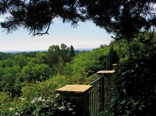
If you still have enthusiasm for a further intake of Sussex scenery, turn right towards the church. In the churchyard go to the right of the church, around its south side. Walk to the far side of the terraced churchyard to gain a stunning view, down through the ghyll-eroded valley, across the green canopy, south to the Downs. A cat may tempt you at this point.
*Distance/Time: Five and three quarter miles, taking two and three quarter hours.
*By Car: West Hoathly one and a half miles off the secondary B2028 Ardingly Road, east on to Selsfield Road, follow signs into the village. Start point Grid Ref TQ363326.
*By Public Transport: Bus details from www.traveline.info, phone 0871 2002233. Bus stop close to start point.
*What’s underfoot: High Weald walking, short section on a quiet road but mostly in woodland with some steep descents and climbs. Possible with a baby backpack, not possible with a baby buggy
*Thirsty Work: The Cat pub in West Hoathly.
*So you don’t get lost: OS Explorer map 135, plus a compass for general direction.


Comments: Our rules
We want our comments to be a lively and valuable part of our community - a place where readers can debate and engage with the most important local issues. The ability to comment on our stories is a privilege, not a right, however, and that privilege may be withdrawn if it is abused or misused.
Please report any comments that break our rules.
Read the rules here