
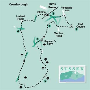
1 - From the entrance to Crowborough Station turn right out to the main road (Crowborough Hill) and turn right beneath the railway. Follow the main road, ignoring side roads until, after about a quarter of a mile, almost opposite the start of Palesgate Lane, a turning to the left, you can turn right along a signed bridleway.
Go over a new bridle bridge, straight across a drive and climb steadily uphill between banks, following the first of the resurfaced and drained trackways featured on this walk.
2 - After a little more than a quarter of a mile, turn sharply right through a bridle gate and follow the direction of an arrow on the gate, downhill across the middle of a field where there is a faint-trodden path.
Pass immediately to the right of an isolated clump of trees and continue with the remains of a fence and hedge on your left. From the bottom field corner an enclosed path passes between two ponds, over a dramatic deeply cut stream and on to join a lane.
Turn left and, after a few yards, at a road junction, turn right along Treblers Road. After another 70 yards, fork left along a concrete drive and, shortly, where the drive veers left through a gate, follow the track ahead and subsequently round to the left where it becomes the access track to various properties.
3 - Just past a house called “Fairways” on the left, fork left along an uphill track. Once over a stile beside a gate, go forward along the left edge of two fields with a stile between them, in the second field crossing high ground with good views.
A few yards after passing beneath minor power lines, go through a gate and turn right to walk beside a right-hand hedge. In the field corner, go over a stile and forward along a wide track, passing between buildings.
Where the track bends left, go ahead along a narrow path between hedges for 30 yards out to join a lane.
4 - Turn right and, after another 30 yards, go left over the remains of a collapsed stile and ahead, following minor power lines across a field. On the other side of the field, a few yards short of a road, to your right, turn sharply left along a track.
Go through a gate and, after a few yards, just past a large shed on your right, fork right across the middle of a field to a gate and along the left edge of the field beyond with a copse on your left.
Where the field edge turns away to the left, go ahead through a shallow dip and up to join a lane in the field corner. Turn right to follow this quiet lane generally southwards.
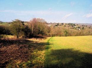
5 - After almost a mile, turn right along a hard-surfaced track, signed with a red arrow as a byway. Follow this track for two-thirds of a mile through to another road. Towards the far end it dips to cross a stream and rises again between high, tree-lined banks.
This fine old hollow way was, at one time, reduced to a morass of deep mud after heavy use by four-wheel drive vehicles. Drained and resurfaced by East Sussex County Council, it is now firm and dry underfoot though it has, inevitably, lost some of its character and atmosphere as an ancient highway.
Turn right to follow this road for two-thirds of a mile. Just past the neatly converted Owlsbury Oast on your left, turn left across an open gravelled area to a gate, then on through a wood to another gate. Continue along a left field-edge, through two more gates and forward along a house access drive, disregarding signed paths to left and right.
6 - At a road, turn right and, after a few yards, go left along Luxford Road. After about 300 yards, when opposite the entrance to Luxford House on your left, turn right along another old tree-lined trackway, following it for a quarter of a mile through to another lane.
If in need of refreshment, the Wheatsheaf Inn is now a short distance along the road to the right but the walk continues to the left, uphill. After about 200 yards, a few yards past a house on the left called “Half Acre”, turn right along the last of the old roads used on this walk.
This one has a tarmac surface but is full of charm and character as it burrows between areas of housing and a large light industrial site, well insulated from its built-up surroundings. It takes you through to a road where you can turn left for a few yards back to Crowborough and Jarvis Brook railway station.
*Distance/Time: Six and a quarter miles taking three and a quarter hours.
*By Car: Start from Jarvis Brook on the eastern edge of Crowborough. Car Park at Crowborough and Jarvis Brook Station (free at weekends) or in car park almost opposite station road entrance (free) – limited long-stay spaces (GR 535298).
*By Public Transport: Train from Uckfield or Tunbridge Wells.
*What’s underfoot: Mostly along good, well-drained tracks plus a mile and a half along quiet roads and short field path links. Undulating terrain.
*Thirsty Work: Wheatsheaf Inn towards the end of the walk.
*So you don’t get lost: OS Explorer 135


Comments: Our rules
We want our comments to be a lively and valuable part of our community - a place where readers can debate and engage with the most important local issues. The ability to comment on our stories is a privilege, not a right, however, and that privilege may be withdrawn if it is abused or misused.
Please report any comments that break our rules.
Read the rules here