
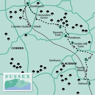
1 - From the entrance to Ashurst Station turn left to follow the access road out to the A264 where you should turn left. Pass beneath the railway, over the River Medway and, after another 200 yards, turn right over a stile to the right of a double gate.
Follow a right field edge and, from the field corner, go ahead, passing beneath the railway. Go through a gate and continue along a right field edge with the river on your right.
Beyond an awkward section of path which squeezes between between river and copse where you must duck beneath a couple of fallen trees, some care is needed as the right of way is undefined and difficult to follow.
Diverge gradually away from the river bank, skirting immediately to the right of another copse and up a grassy bank. Maintain direction across a field, passing closely to the right of a pond and on for 100 yards to join a tarmac farm drive where you should turn right.
2 -Walk between all the buildings at Willett’s Farm and, in the same direction, drop down across a field, aiming to pass immediately to the right of an isolated tree to find and cross a footbridge.
Turn left along a field edge and, after 70 yards, left again over another footbridge and ahead along a valley, never far from a meandering stream on your right and, at one point, crossing a short section of golf course. After about a quarter of a mile, join a lane, turn right for ten yards, then go left over a stile and continue along the valley, walking roughly parallel to the stream on your left.
3 -After another quarter mile, turn right over a stile and head half-left, gently uphill across a cultivated field, where a trodden path should be visible through any growing crop.
On the other side of the field, go ahead for 100 yards across rough pasture, pass through a narrow metal gate and forward, passing to the right of a barn to join and follow the access drive from a fine old brick and timber-fronted house (Prinkham) out to a lane. Turn left.
4 -Shortly, ignore the first signed path to the right and, after a few more yards, go right along a second signed footpath which starts here, then over a stile and along a right field edge. After 100 yards, go forward over a stile and plank bridge and along a woodland path.
Leave the wood over a stile and keep to the right edge of a field, following it round to the left with a wood on your right all the way. Go ahead through a wide gap at a point where a striking sandstone outcrop rises on your left
5 -Continue along a wide grassy strip with more similar rocky outcrops over to your left. Go over a stile in the far left corner of this long, thin field and on along a path within the right edge of an area of old coppiced woodland, a fine spot for bluebells in the spring.
Leave the wood over a stile and, without change of direction, head out across a field to find and cross another stile. Once over this stile, turn right to climb gently along a right field edge.
Cross another stile about 20 yards to the left of the field corner, pass to the left of a pond and head squarely out across a field to join a road in the far right corner.
From this point, a left turn along the road provides a short cut to Cowden Station but, for the full walk, passing the pub at Markbeech, turn right and, after 250 yards, at a road junction, turn left and follow a lane for another quarter of a mile to Markbeech.
6 -At a road junction next to the Kentish Horse pub, turn left and shortly, just past a gateway to Markbeech and Hever Church, turn left over a stile and follow a path which follows the right edge of the churchyard for a few yards to another stile.
Now head slightly left across a field and go through a gap to the right of a wastewater treatment area. Drop downhill along a left field edge until you can sidestep to the left over a stile and resume your previous direction, now walking downhill along a right field edge.
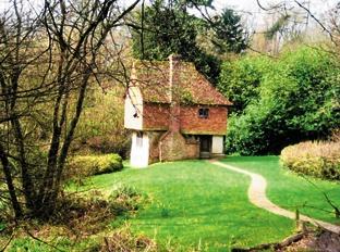
In the bottom field corner go over a stile and follow a well-established woodland path. Join the access drive from a tiny, secluded fairy-tale cottage and, after a few yards, where this drive curves away to the right, go ahead along a woodland path.
Disregarding signed paths to right and left, follow this delightful woodland path for about 400 yards out to a road, turn left beneath the railway and, after a few yards, left again along the approach road to Cowden station where the walk ends.
* If you would like a longer walk, today’s outing can be linked with the previous linear walk in the series from Eridge Station to Ashurst, adding up to a total of almost 11 miles. For an even longer 17-mile trek, join up all three walks linking Crowborough and Cowden. Both of the earlier walks can be downloaded from www.theargus.co.uk
* Distance/Time: Five and a quarter miles taking two-and-a-half hours.
* By Car: Small car parks at Ashurst and Cowden Stations – likely to fill up on weekdays but plenty of room at weekends.
* By Public Transport: Hourly train service along the line between Uckfield and Oxted.
* What’s underfoot: Easy walking along field or woodland paths. Gently undulating terrain.
* Thirsty Work: Kentish Horse pub at Markbeech (point 6).
* So you don’t get lost: OS Explorer 147.


Comments: Our rules
We want our comments to be a lively and valuable part of our community - a place where readers can debate and engage with the most important local issues. The ability to comment on our stories is a privilege, not a right, however, and that privilege may be withdrawn if it is abused or misused.
Please report any comments that break our rules.
Read the rules here