
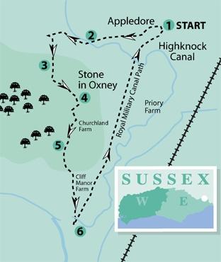
1 - Start the walk along Court Lodge Road, signed to Stone, which heads east from the main street through Appledore almost opposite the church (GR 958292). A few yards past the entrance to Court Lodge on your left, turn left into the start of the drive to a house called Court Barn and immediately turn right up steps, over a stile and ahead across grass.
For the next three miles, the walk is mostly along part of the Saxon Shore Way, a long-distance path for walkers which follows, as far as possible, the old Roman coastline around Kent.
On reaching a prominent grassy mound with a flat top, probably once occupied by a windmill, bear right, dropping steeply down to a stile and footbridge from which a clearly defined path continues along the right edge of a large field and subsequently with a substantial waterway, the Reading Sewer on the left for a while, before heading out across a field to join a road.
2 - Turn left across a brick bridge over the Reading Sewer, formerly the River Rother between the Isle of Oxney and Appledore before the main watercourse was diverted in the 17th century on to a more direct route.
When opposite the Ferry Inn on your left, turn right through the pub car park and follow a track, now with the Reading Sewer on your right.
Immediately after passing to the right of a small brick pumping station, fork left, now with a more modest but deep-cut drainage channel on your left. After 250 yards, turn left across this channel and follow a concrete track.
About 100 yards short of buildings, the right of way diverts from the track to run on a parallel route as it skirts to the right of the buildings to join a road.
3 - Cross the road and follow the drive to “Luckhurst”, opposite. Shortly where the drive bends left, go ahead and along a tree-lined path. After about 100 yards, side-step to the left over a plank bridge into a field corner.
Now turn right to follow the generous grassy headland round two sides of this field. From the far corner go through a gap and head out across the middle of the next field to join a road at Stone-in-Oxney.
4 - Cross the road to follow the lane, opposite, signposted to Stone Church, leaving the Crown Inn on your right. After a little over 200 yards, turn right along a signed footpath which starts up a drive for a few yards, then continues within a wide grassy strip to a gate. Maintain direction up across grass until, after about 100 yards, when you are in line with a stile away to your right, you should turn left through almost 90 degrees.
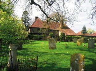
Go through a gate in a crossing fence, descend to cross a culvert in a dip and climb, aiming towards Stone- in-Oxney church. Enter the churchyard through a gate. The church, rebuilt in 1464 after a fire, is notable for the remains of a Roman altar. Rejoin the lane through the main church entrance and turn right to follow the lane out of the village.
5 - On reaching a road junction, go ahead through a metal swing gate and forward along a right field-edge, crossing high ground.
In the field corner, go through a wooden swing gate and head half-left across the next field where a panoramic view opens out ahead across the valley of the River Rother.
The path soon drops obliquely down into the valley, passing through several similar swing gates. At the bottom of the hill, go forward over a plank bridge and along a headland path.
Join a track for a short distance and, shortly, on reaching a small brick shed, fork right with a ditch on your right. Follow this path as it bends left, right and finally left again across a wide farm bridge to join a road.
6 - Cross the road, go over the stile opposite and turn left along the top of a grassy bank. The waterway on your right is the Royal Military Canal which you can now follow for about three miles back to Appledore.
The canal, constructed as one of the defences against a Napoleonic invasion, was completed in 1808, only after the threat of invasion had passed, but remains as a haven for wildlife and, in spite of the nearby road, offers pleasant walking along its raised northern bank, planted with a variety of trees.
A stone structure with a mushroom-like top, passed soon after joining the canal, marks the Kent-Sussex border.
Where the canal reaches the B2080 road on the edge of the village, turn left into Appledore, once a seaport on the Rother estuary before the sea receded. If time allows, you might like to extend the walk along the wide and picturesque village street as far as the village centre.
* Distance/Time: Six and three quarter miles/three and a half hours.
* By Car: Start from Appledore on the B2080 road between Rye and Tenterden. Roadside parking is possible beside the village street or in the car park at the northern end of the village, adding half a mile to the walk.
* By Public Transport: Train to Appledore on the Hastings to Ashford line, one and a half miles from the start of the walk via road and footpath.
* What’s underfoot: Excellent walking, mostly along clear, well-established paths.
* Thirsty Work: Pubs at Appledore, Stone Ferry (point 2) and at Stone-in Oxney.
* So you don’t get lost: OS Explorer 125


Comments: Our rules
We want our comments to be a lively and valuable part of our community - a place where readers can debate and engage with the most important local issues. The ability to comment on our stories is a privilege, not a right, however, and that privilege may be withdrawn if it is abused or misused.
Please report any comments that break our rules.
Read the rules here