
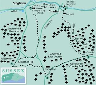
1 - From the centre of Charlton, opposite The Fox Goes Free pub (there’s a clue there), and close to the bus stop, head up the lane beside a long, low flint barn. Branch right and in a few yards, after a paddock and flint wall on the left and at a road junction, turn left. Follow the surfaced road, passing a war memorial, continuing beside cottages and passing behind Fox Hall. One of Charlton’s claims to fame is the local hunt, of that name and now long-gone. Fox Hall was constructed so a chap could have a good day on horseback, then get some decent food, frolics and fun in the evening. The local hunt whippers-in would have retired to the alehouse, having earlier locked up their wives and daughters. Perhaps it was partly the folk memory of such incarceration that prompted local women, in 1915, to hold the inaugural meeting in England of the Women’s Institute at the local pub. The lane steepens becoming a rougher track, known as Chalk Road, taking sweeping left and right turns as it climbs between banks through the wooded Charlton Park. There are occasional glimpses to the left of surrounding Downland. After three-quarters-of-a-mile white rails become apparent through hedgerow on the right, indicating that the bridleway is now near the hilltop, alongside Goodwood racetrack. Continue along the wide bridleway, which, in a further half-mile, comes to the roadside at Counter’s Gate.
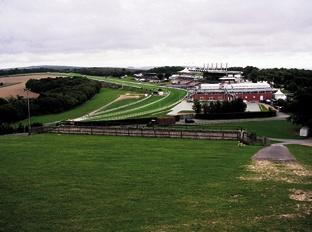
2 - Turn right along the road, with the racetrack up a bank on the right. On approaching the five-furlong post, being firm in the saddle and with a strong grip on the bridle, bring your steed’s nose round to the left, crossing the road and entering a small roadside clearing. Immediately branch right, at a relaxed trot, to enter the woodland of Birdless Grove and, accompanied by birdsong, follow an unsigned, wooded path for 200 yards. On clearing the trees and coming to open country it is possible to drop the reins for a leisurely canter up the rising slope ahead. At the top of the gallop ride, (actually it’s a car park) skirt around railings, cross a track and pass across the top of the hill, with the buildings of the racecourse across the road on the right. Keep to the grassed path beside the road, which sweeps left opposite the grandstand buildings, and descends to a junction, in a quarter-of-a-mile.
3 - Turn right up the roadside verge for 300 yards and then cross left to a track that passes across a clearing. Do not take the bridleway that enters woodland on the left but continue to the right. In a few yards branch left and commence a climb up the hillside on a surfaced path, with the open stand structures on the right. This hill is known as The Trundle and has a varied history dating from Palaeolithic times. A defensive structure has stood here, a chapel, a windmill and, so legend has it, a buried golden calf.
Continue up the hill, crossing a stile and passing through a gap in the earthwork ramparts, keeping left of the phone masts. A detour to the obvious trig point off to the left offers a full 360-degree panorama, west to the Isle of Wight, north across the rolling Downland, far to the east and south taking in distant hills and the coastal plain.
Return to the path and continue westward, clearing the ramparts, descending a track across St Roche’s Hill, to pass through a gate and continue towards a small car park and surfaced road.
4 - Turn right and immediately right again through a bridle gate, taking a half-left line across the north-western flank of the hill, skirting around to the right and descending on a bank to the roadside. At the mid-point of the path note the prominent cross dyke, a boundary or defensive structure, down to the left.
Turn right along the road edge, with care and keeping to the grass verge where possible, and in 250 yards cross to a road branching left, with a car park to the right. At a left turn in 100 yards, follow the quiet, single-track road on Knight’s Hill for a quarter-of-a-mile. On coming to a path sign, up a bank on the left, take this turning and follow the enclosed route for a little over half-a-mile, with delightful views across the valley to the rooftops of Singleton. The final, steeper section of the path soon levels-off and passes beside Manor Farm, heading for the obvious boundary wall of the village churchyard.
5 - Enter the churchyard, following the signed path to the left, around the wall, to the far corner, and turn right (yellow arrow). A detour to visit the Saxon church is possible at this point. On arriving beside the church entrance gate take a few paces left and then turn right across the church car park, passing a children’s playground, which is off to the right.
In a few yards walk between dwellings and cross a road, in a small housing estate. Keep direction eastwards, passing between two houses and clearing the estate, going right and then left onto a field-centre path. Follow the obvious trodden path over the meadow, back to the edge of Charlton. Pass through a metal gate in hedgerow and turn left to the main valley road. Go right, back to the finishing post, opposite the village pub.
* Distance/Time: Five-and-a-half miles, taking two-and-three-quarter hours
* By Car: Roadside parking in Charlton village. Start point, GR SU889130
* By Public Transport: Bus details from www.traveline.info or 0871 2002233. Bus stop close to the start point on Charlton Road in Charlton village
* What’s underfoot: A couple of easy climbs, but mostly open hillside walking on well-drained paths. Possible with a baby backpack. Not easy with a baby buggy because of two stiles, but just about possible if you’re determined. Not possible on horseback
* Thirsty Work: The Fox Goes Free pub in Charlton
* So you don’t get lost: OS Explorer map 120


Comments: Our rules
We want our comments to be a lively and valuable part of our community - a place where readers can debate and engage with the most important local issues. The ability to comment on our stories is a privilege, not a right, however, and that privilege may be withdrawn if it is abused or misused.
Please report any comments that break our rules.
Read the rules here