
1 - From Falmer railway station, use the underpass to get beneath the A27 on to the University of Sussex campus. After 60 yards, turn left along a tarmac path, labelled for cyclists and pedestrians. Join a road for a few yards and then turn right through the main entrance to Stanmer Park. Follow the main drive through the park where you can avoid the tarmac by walking within the parkland on either side.
Much of this 5,000-acre area of parkland, first laid out in the 18th century, is open to the public. The Palladian-style Stanmer House was built in 1722 for the family of Sir John Pelham, the Earl of Chichester. The church, nearby, dates from 1838.
Where the drive divides, either will do as they rejoin behind Stanmer Church. At one corner of the churchyard opposite this road junction, a small flint building houses a donkey-wheel, only occasionally open to view but just visible through a glass panel in the door. From here, continue along the road through Stanmer village, passing the Stanmer Tea Rooms on the right. Where the road bends left, go ahead along a farm track.
2 - After about 250 yards, fork left at a Y-junction. From here to point 3, you will be following a route within public access land.
The path is marked in red on the latest Explorer map but not earlier editions.
After about a quarter of a mile, about 70 yards short of a field corner, turn right through a gate and along a woodland path. Where the path divides, keep right and continue up through the wood, ignoring side paths.
3 - After about half a mile at GR 330115, turn left along a wide crossing track and, at a Y-junction, turn right for a few yards out to join the Ditchling Beacon road at High Park Corner.
Go through the bridle gate, almost opposite, and drop gently downhill along a left field edge where views open out ahead and to the right up towards Ditchling Beacon. Pass through another bridle gate and follow a right-hand fence as it contours along a grassy slope.
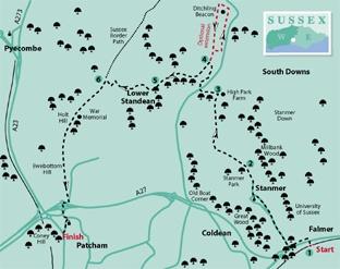
4 - From the field corner, on Heathy Brow, a fenced track to the right allows an optional extension up to the spectacular viewpoint on the summit of Ditchling Beacon, returning either the same way or, for part of the distance, along a parallel bridleway to the east (see map, top right). This would add about a mile and a half to the total length of the walk.
To continue the shorter, described route, in the field corner, turn sharply left and drop down into and along the floor of a dry downland valley (North Bottom).
Go through a gate and continue along the valley floor, soon with a fence on your right, until you can side-step to the right through a bridle gate in this fence and resume your previous direction, now with the fence on your left.
5 - Join a track and shortly, at a waypost with a logo numbered 39, fork right on a track which climbs obliquely up the right side of the valley. Follow this, unfenced, as it levels out along the hillside to a gate and then drops down beside a left-hand fence to join a farm track just to the west of the farm buildings at Lower Standean.
Turn right to follow this track uphill. About 70 yards after passing a brick and flint-walled storage barn on your left, go through a bridle gate to the right of a double farm gate and immediately turn left, to climb beside a left-hand fence, following it as it veers right.
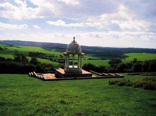
6 - Where the ground levels out, turn left through gate and follow a track, unfenced at first, then along a right field edge, walking towards the sea, in distant view. After about half a mile, just past a gate, a short there-and-back detour down the hill to the left allows a visit to the Chattri.
Built in 1921, using Sicilian marble, the Chattri commemorates the 53 Indian soldiers who died while hospitalised in Brighton during the First World War and were cremated on this spot.
Continue the walk along a gradually descending ridge. At the end of the last field before the built-up area, go through a gate to join a lane and bear right for a few yards to a junction where you should turn right down a slip road.
At the bottom of the slope, go left, skirting to the left of a roundabout, then across the Brighton bypass and past a second roundabout. Shortly turn left, soon joining Vale Avenue.
After a few more yards turn right down Church Hill, noting in a garden to the right, a flint-walled dovecote and, to the left, the converted 17th century tithe barn and Patcham parish church.
At the bottom of the hill, where the walk ends, you can catch a bus into Brighton from the stop next to the Black Lion pub.
* Distance/Time: Six and a half miles (or eight miles, including optional extension to Ditchling Beacon)/three (or three and three quarter) hours
* By Car: Park in the car park just inside the entrance to Stanmer Park, returning to the start by bus or bus and train via Brighton
* By Public Transport: Train to Falmer Station or nearby bus stop from Brighton or Lewes. Bus back into Brighton from Patcham at end of walk
* What’s underfoot: Excellent walking along good paths or tracks. One long steady climb and two shorter ascents.
* Thirsty Work: Tea rooms at Stanmer village.
* Pub and tea rooms at Patcham
* So you don’t get lost: OS Explorer 122


Comments: Our rules
We want our comments to be a lively and valuable part of our community - a place where readers can debate and engage with the most important local issues. The ability to comment on our stories is a privilege, not a right, however, and that privilege may be withdrawn if it is abused or misused.
Please report any comments that break our rules.
Read the rules here