
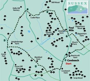
1 - From the road junction next to the Merry Harriers pub at Cowbeech, start the walk southwards through the village. About ten yards beyond the speed de-restriction signs on the edge of the village, turn right to a stile and gate, set back from the road.
A path continues up a bank, along a right field-edge and through a wood where you should ignore all side and crossing paths until, at a Y-junction, you can fork right for 60 yards to leave the wood past the remains of a stile.
Head slightly left across a field where there should be a trodden path. About half-way across the field, turn squarely right where, once again, there should be a faintly visible trodden path.
Head for the field corner where you can go through a gate and bear left downhill along a wide dirt track which, beyond a gate, acquires a concrete surface.
2 - At a T-junction, turn right, passing Blackford farmhouse on your left. Shortly, at a Y-junction, fork left through a farmyard, passing between buildings and go through a black-painted gate.
Drop down across a field, not on the visible track but aiming for the bottom right corner where you will find a stile and a path through scrubby woodland to another stile. Head diagonally across the middle of a field to reach and cross a footbridge.
Once over this bridge, turn left along a path which has been well-cleared through a neglected low-lying area, to reach another footbridge. From here you should go ahead across a meadow, aiming for farm buildings, visible through a gap in trees.
Join and follow a left field edge to a stile, maintain direction across the next field to a stile and footbridge, then veer half-left across the field beyond to join a road and turn right.
3 - After about 250 yards, about 80 yards beyond the last house on the right, turn right over a stile beside a gate and head squarely out across a field, passing obliquely beneath power lines. Pass to the right of a clump of trees to reach a stile in the corner.
Head very slightly left down across the next field where a faint trough in the grass marks the line, to reach and cross a footbridge, then go half-left across a low-lying meadow to a gap in the corner and follow the left edge of the next field.
From a stile and gate in the corner, maintain direction across the next field to a broken stile and on over two more fields and two footbridges, then along a fenced path through trees and on, squeezing between gardens to join a road.
4 - The walk continues from the other side of the road, a few yards to the left, along the drive to Cralle Place. Pass through the first gate and, just short of a second, electrically operated, gate, fork right and, after a few yards, fork left along a grassy path which passes between gardens and continues through woodland to reach and pass through a dilapidated gate.
5 - Some care is now needed as the next path is unsigned and it is easy to go adrift. Once through the above-mentioned gate, bear half-right up a bank and uphill across a field, walking roughly parallel to the right-hand hedge.
About 60 yards to the left of the field corner at GR 614162, unsigned and far from obvious, cross a plank bridge over a ditch, pass through a thin line of trees, go over a fence using a rudimentary stile, constructed from two sawn logs, and head squarely out across the next field.
Pass immediately to the right of a clump of trees protruding into the field from the left to reach the field corner where you can cross a concrete culvert and gate. Follow the direction of an encouraging yellow arrow on a gatepost slightly right across the next field.
Go through a double-width gate next to a water trough a few yards to the right of the field corner and maintain direction across the field beyond. On the other side of the field you have a choice of two gates ahead. Go through the one on the right and, once again maintain direction across another field, passing beneath power lines.
Go over a stile, and ahead, now thankfully along a well-defined path.
At a T-junction with a large pond in front of you, turn left and, after 40 yards go right through a gate and ahead across grass with buildings away to your left.
Go over a stile and turn left beside a post-and-rail fence, then through two gates to join a road at Foul Mile where you should turn right.
6 - After a little over 100 yards, turn left along a gravel track to a stile and forward along a right field-edge. After less than 100 yards, at a waypost, turn right over a stile and along a field edge.
In the field corner, cross a track and continue on a stiled path along the right edge of four fields. At the end of the fourth field, go over a stile and immediately right over a second stile.
Head squarely across a field to a stile then half-right across a second field to join a lane. Turn right to follow the lane for a quarter of a mile back into Cowbeech.
* Distance/Time: Five miles/two and a half hours.
* By Car: Start from Cowbeech, signposted northwards from the A271 road about a mile east of Hailsham. Roadside parking is possible in various places along the village street south of the Merry Harriers pub (GR 619144).
* By Public Transport: None practicable.
* What’s underfoot: Field paths, some little used and poorly signed, requiring careful navigation.
Map and compass advisable.
* Thirsty Work: Merry Harriers pub at Cowbeech.
* So you don’t get lost: OS Explorer 123.


Comments: Our rules
We want our comments to be a lively and valuable part of our community - a place where readers can debate and engage with the most important local issues. The ability to comment on our stories is a privilege, not a right, however, and that privilege may be withdrawn if it is abused or misused.
Please report any comments that break our rules.
Read the rules here