
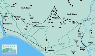
1 - From the entrance to Newhaven Town Station, turn right and immediately right again along Railway Road. After 100 yards, turn left along Estate Road. Where this ends, go ahead along a narrow path with a high perimeter fence on your right.
Follow the path round to the right, fenced between two large industrial area car parks. Go ahead across grass and up steps. After a few more yards, go left down a bank and along a clear path which soon emerges from scrub to traverse part of the low-lying Ouse Estuary Nature Reserve. Follow this path out to join the A259 road.
2 - Cross the road, turn right along the opposite verge and, after ten yards only, turn left through a gap in a bank and along a gravel track.
After 100 yards, where this track ends, go over a stepless stile and turn right to climb gently within an overgrown unfenced strip between two arable fields. If impassable you can sidestep right to walk along the parallel left edge of the adjoining field.
At the top of a low rise, go over a stile beside a gate and forward between widely spaced fences. Pass to the left of stable buildings and continue along a wide gravel path. Where this hard-surfaced path bends left, go ahead over a stile and follow the direction of a sign up across a field, aiming for a stile on the skyline.
3 - Once over this double stile turn right to head across the ridge of Rookery Hill, diverging gradually from the fence on your right and aiming for the sharply defined prow of Seaford Head, in distant view.
Feed into a defined path which enters trees via a swing gate and drops obliquely down a wooded slope. At the bottom of the hill, turn left through a similar gate and follow a flint wall, on your left, to a third gate.
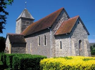
Now head half-right across a meadow with the stumpy tower of Bishopstone Church directly ahead. Go over a stile, left along an access track and, after 40 yards, right along a house drive. Shortly go left up steps and diagonally across a meadow to enter Bishopstone churchyard.
The church is one of the oldest in the county, a typical flint-built downland structure with a 12th-century flint tower, rising in four stages, and much of the rest of the building dating from even earlier. Note the Saxon sundial above the porch doorway.
Leave the churchyard via the main entrance, turn right along the church access road to a lane and turn left.
4 - After 70 yards, turn right along a wide farm track, signed as a bridleway to East Blatchington. Climb steadily, ignoring a track off to the left. Where your track begins to bend right, fork left along a narrow hedged path.
Beyond a stile a path contours along the hillside with a scrub-covered bank on your right and a grassy slope dropping away to the left. Through a gate, maintain direction along the right edge of a large arable field.
5 - After a little over a quarter of a mile, at a junction with a hedged track, turn left. At another junction, turn sharply back to the right along another wide path between hedges.
After about three quarters of a mile, fork left through a gate to follow a signed path along the left edge of a large field of close-cropped downland pasture, a National Trust open access area.
After almost half a mile, go through a gate and, after another 100 yards, ignoring a gate ahead, bear right, continuing along the left field edge to join the Alfriston to Seaford road over a stile.
6 - Turn right beside the road and, after 60 yards, go left across the High and Over car park and follow a hard-surfaced path which starts between two wooden posts. Follow it out to reach a magnificent viewpoint overlooking the Cuckmere Valley.
Follow a path past a topograph identifying various features in view, down steps and through a swing gate. Now turn right to pass through a similar gate and follow a right-hand fence along the hillside.
In the field corner, turn left and drop down into the valley, still along a right field edge.
At the bottom of the hill, side-step to the right through a gate and drop down to join the Cuckmere River bank.
Turn right to follow the riverside path, usable except at times of high spring tides when you may have to divert temporarily up the bank to your right. Approaching the A259, the path leaves the river bank to exit to the A259 via a stile.
Turn left beside the road to reach Exceat Bridge and the Golden Galleon pub where there are stops for buses in both directions along the coast road, either on to Eastbourne or back to Seaford and Newhaven.
Alternatively you might like to walk beside the road across the valley as far as the Seven Sisters Country Park Centre and tea rooms (limited opening times during the winter months).
* Distance/Time: Six and three quarter miles/three and a half hours
* By Car: Parking at Newhaven and Exceat.
Frequent bus service between these two points
* By Public Transport: The walk starts at Newhaven Town Station. Train from Brighton or Lewes on the Seaford line or bus No 12 from Eastbourne or Brighton, alighting at stop next to station. Bus back from Exceat (bus stops next to Exceat Bridge and Seven Sisters Country Park Visitor Centre)
* What’s underfoot: Good walking, almost entirely along clear downland paths and tracks. One short climb on to Rookery Hill and a longer but well-graded ascent from Bishopstone to High and Over
* Thirsty Work: Golden Galleon pub at Exceat Bridge.
Tea rooms at Exceat Farmhouse behind Seven Sisters Countryside Centre. Pubs at Newhaven
* So you don’t get lost: OS Explorer 123


Comments: Our rules
We want our comments to be a lively and valuable part of our community - a place where readers can debate and engage with the most important local issues. The ability to comment on our stories is a privilege, not a right, however, and that privilege may be withdrawn if it is abused or misused.
Please report any comments that break our rules.
Read the rules here