
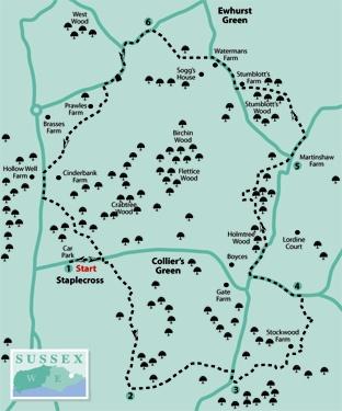
1 - From the Staplecross car park, turn left and head east beside the road. After about 200 yards, turn right through the wide wooden gate to a house called Sideways. A few yards short of the house, turn left along a fenced path and, at a T-junction with a wider fenced path, turn right.
Go over a stile beside a gate, forward across a paddock, through another gate and slightly left, downhill, across a second paddock. At the bottom of the hill, go through a gate, over a culvert, then turn right along an indistinct woodland path, near the stream for a few yards, then bearing left to follow a right-hand fence.
After less than 100 yards, go right over a stile in this fence, half-left across a field corner to another stile, then ahead on a stiled path which follows the left edge of three fields.
2 - Emerging into a fourth field, turn left along the left field edge, soon skirting to the right of a deep tree-shrouded pit. Go over a stile in the field corner and head slightly left across the next field to another stile.
Go ahead along a left field edge and, after less than 100 yards, go left over a plank bridge and stile and bear right along a wide grass strip with a fence and a row of newly-planted trees on your left. Follow this fence out to Ellenwhorne Lane and turn right.
3 - After about 100 yards, turn left over a stile beside a gate and head slightly left, downhill with a hedge on your left, through two fields. Cross a footbridge in a wooded dip and bear left round the left edge of the field beyond, climbing steadily.
At a junction with a concrete-surfaced track, turn left. Just short of the outbuildings at Stockwood Farm, turn right, skirting to the right of a large storage shed and a garden.
At the far corner of the garden, turn left with the garden still to your left and, after 30 yards, go right over a stile and follow the left edge round two sides of a field.
Just past a small pond on your left, go half-left through a gap and across a field, converging on the right edge.
In the corner go over a stile and immediately right through an awkward gate, constructed from sheep hurdles and wattle fencing, then turn left for 60 yards to join a road over a stile.
4 - Turn left and, at a road junction, turn right, signposted to Hurst Green. After another 250 yards, turn left over a broken stile and follow a path through old coppiced woodland.
Leave the wood over a stile and bear right, skirting to the left of a pond and garden and dropping down to a footbridge. Over the bridge, veer slightly right up through trees and leave the wood by scaling a low sheep wire fence.
From here the official path may be obscured by a growing crop. Your best bet is to turn right and follow the right edge of this large arable field as it rounds a peninsula of woodland.
Care is now needed as the next path is not obvious. Just past a pile of old logs at GR 798232, turn right along a currently unsigned and indistinct path which descends to cross a stream via an impressive earth causeway and brick culvert. Continue uphill, over a stile and on with woodland nearby on your left to join a lane next to a road junction using an overgrown stile.
5 - Go ahead along Sempstead Lane, signed to Northiam. After about 200 yards, go left over a stile and ahead along a right field edge. In the field corner go forward through woodland, following the path as it curves left, leaves the wood over a stile and follows a fenced route out to a lane where you should turn right.
After a little over 200 yards, where the lane bends right, go left into the start of the drive to Sogg’s House and immediately turn right along a fenced path. From the end of this enclosed path, the right of way is very well signed through new parkland to join a lane where you should turn left.
6 - At a road junction, fork left and after 350 yards go left over a stile and right for a few yards through trees, before curving left across pasture to a gate/stile and on across a field to another gate/stile combination.
The path now skirts to the left of houses and gardens. Your route is well signed across a field, along the right edge of a second field and half-right across a third field to join a lane.
Turn left and, after about 200 yards, turn left again through a gate and head squarely up across a field.
Go over a stile beside a gate, follow a track to a second gate, then keep close to the left edge of the next field until you can go left over a stile and immediately right over a second stile.
Turn left across a field, pass through a gateway and shortly trend right, skirting to the left of a house and garden to join a road. Turn right back into Staplecross.
* Distance/Time: Six miles/three hours
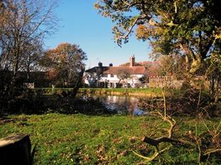
* By Car: Start from Staplecross, most easily accessible from the B2244 between Sedlescombe and Hawkhurst. Park in the small car park next to St Mark’s Church on the north side of the road to the east of the village at GR 784225
* By Public Transport: Two-hourly bus service to Staplecross from Hastings or St Leonard’s
* What’s underfoot: An undulating route along mostly well-established paths, though it is easy to go astray in one or two places
* Thirsty Work: Pubs at Staplecross and at Ewhurst Green, about half a mile off the route between points 5 and 6
* So you don’t get lost: OS Explorer Map 124 plus a short section of the walk on Map 136


Comments: Our rules
We want our comments to be a lively and valuable part of our community - a place where readers can debate and engage with the most important local issues. The ability to comment on our stories is a privilege, not a right, however, and that privilege may be withdrawn if it is abused or misused.
Please report any comments that break our rules.
Read the rules here