
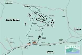
1 - From the entrance to Housedean Farm, start the walk along the tarmac path in the Lewes direction beside the A27.
After a few yards, turn left up steps, signed as the South Downs Way, to Ditchling Beacon and climb steadily along a left field edge.
Continue down through a wood and then climb again between fences. At the top of the slope, turn left along a left field-edge, still with the South Downs Way.
2 - After about two-thirds of a mile, go through a bridle gate, and immediately, parting company with the South Downs Way, turn sharply back to the right, dropping gently downhill beside a right hand fence.
Where this fence turns away half-right, go straight ahead with a scrub-covered bank dropping away on your left. Go ahead through a wood and then down across a field into Ashcombe Bottom.
3 - At the bottom of the hill, ignoring the farm gate to your left, go through a bridle gate, straight over a crossing path and ascend steeply up the other side of the valley with scrub on your left.
Emerging from the scrub at the top of this short, sharp slope, go left for 30 yards to pass through a bridle gate and then veer half-right across a large field. Go through another bridle gate in a crossing fence and bear half-right along an unfenced but defined path.
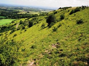
At the field edge, ignoring the gate ahead, turn left to follow the right field-edge. Immediately after passing beneath power lines, turn left along a clear, unfenced chalk and flint track which you can now follow for two thirds of a mile up to the tree clump and trig point on Blackcap.
The tree clump, replanted some years ago, is now reaching maturity and looks much like Chanctonbury Ring did in its heyday, before it was virtually destroyed by the Great Gale of 1987.
The view from the 600ft summit is superb. The twin profiles of Mount Caburn and Firle Beacon are easily recognisable and Seaford Head can be picked out, rising sharply to the left of the Newhaven gap at the mouth of the River Ouse.
A sweeping view of the Downs escarpment between Kingston and Newmarket Hills and a wide expanse of the Weald to the north complete this spectacular panorama. Pass to the left of the clump, continuing along a clear path to reach a gate.
4 - For the shorter walk, omitting the descent to the Half Moon at Plumpton and the steep climb back up again, but also, two of the best paths on the walk, go through the gate and turn left along a fenced track, signed as the South Downs Way to Housedean Farm.
For the full eight-mile walk, just short of the gate, turn right along a chalk track, soon between banks, which starts to drop down the northern scarp slope of the Downs. After about 200 yards, at a waypost, turn left along another terraced path which drops obliquely down the wooded slope.
Ignore a waymarked footpath to the right and, after another 200 yards, look out for a stile on the left, set back from the path and not immediately obvious, from which a trodden path heads down across two fields to reach the B2116 road.
Just short of the road, turn left, where a useful “behind the hedge” path segregates walkers from the tarmac at first, eventually joining the roadside verge.
5 - When opposite the start of Plumpton Lane to your right, and a few yards short of the Half Moon pub, turn left along a farm track, signed as a public bridleway which provides a well-graded climb back up the hill.
After about 400 yards, turn left through a bridle gate and follow another superb terraced bostal path as it curves round the head of a combe up to the summit of the downland ridge with an ever-widening view northwards into the Weald.
At the top, either join and turn left along the South Downs Way or, for a better route, stay within the open access land, walking parallel and to the left of the rather unappealing track which carries the South Downs Way, joining this track through a swing gate a few yards short of point 4 where you will rejoin the shorter walk and can turn right, signed to Housedean Farm.
6 - After about two-thirds of a mile, where the South Downs Way goes off to the left, go straight ahead, following a glaringly white compressed chalk track which soon rises to cross a low hill (Balmer Huff), passing about 40 yards to the left of the summit trig point.
The distant tower blocks of Brighton are now in sight ahead, as well as the roof girders of the new Albion stadium. At Balmer Farm, follow the track between the buildings where it becomes the access drive from several cottages and takes you down to the A27.
Just short of the main road, turn left along the parallel access road which brings you back to the start.
If catching a bus into Brighton, there is a convenient bridge over the dual carriageway to the bus stop on the southern side of the A27.
* Distance/Time: Six and a half miles for the shorter walk, taking three hours, or eight miles/four hours for the longer route
* By Car: Roadside parking is possible beside the access road to Housedean Farm on the north side of the A27 about two-thirds of a mile east of Falmer (GR 367092). Keep well clear of the farm entrance to avoid impeding farm traffic
* By Public Transport: Frequent bus service between Lewes and Brighton along the A27
* What’s underfoot: All along excellent downland paths and tracks. Several ups and downs including a steep climb up the downs escarpment on the longer walk
* Thirsty Work: Half Moon pub at Plumpton (point 5 – longer walk only)
* So you don’t get lost: OS Explorer 122


Comments: Our rules
We want our comments to be a lively and valuable part of our community - a place where readers can debate and engage with the most important local issues. The ability to comment on our stories is a privilege, not a right, however, and that privilege may be withdrawn if it is abused or misused.
Please report any comments that break our rules.
Read the rules here