
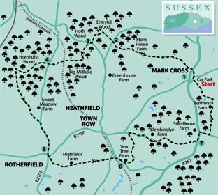
1 - From the entrance to the Mark Cross car park, turn left, leaving the Mark Cross Inn on your right. Join and cross the A267 road and follow the signed, fenced footpath opposite, which starts down steps and then squeezes to the left of a garden centre.
Where the enclosed path ends, veer half-right across undulating pasture, past a helpful waypost and on to a stile at the far end of the field. From here a well-trodden path continues through woodland.
After leaving the wood, go forward within an area of patchy scrub to a stile and squarely ahead across two fields. In the second field, converge on the right field edge to find and cross a stile hidden in the hedge.
Go ahead, walking parallel to the right edge of the next field, pass through a gateway a few yards to the left of the field corner, right for ten yards to a stile, then half-left across the next field.
Go over a stile next to a dark-coloured wooden gate and follow a clear woodland path which soon descends to cross a stream and continues to join a lane.
2 - Turn right and, after ten yards, go left along the drive to Entry Hill. Just past a house on your right, where the drive ends, bear right, leaving an outbuilding on your left. Go through a bridle gate and follow a path at the foot of a sloping area of heathland and patchy scrub.
Just past staggered railings, turn sharply back to the left along a clear track which climbs steadily, dog-legging right. Towards the top of the hill, fork left along a track, signed as a byway, which takes you out to a lane.
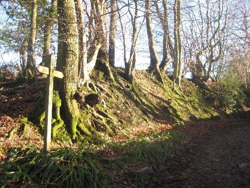
3 - Turn right and, after a few yards, fork left through a gate into Big Millhole Wood. For the next mile, care is needed as there are many alternative paths to lead you astray. Our route follows public footpaths, mostly well-signed with yellow arrows.
Follow the main path through the wood, eventually dropping down to pass beneath an old railway bridge, which once carried the Cuckoo Line northwards from Heathfield.
Cross a stream and climb through woodland, soon following the main path as it turns squarely right. At a waypost, turn right along a narrower path for 100 yards out to join a lane.
4 - Your next path, through Hornshurst Wood, once again requires careful navigation. Follow the footpath signs and yellow arrows. Beyond staggered railings, go straight over a crossing track. Keep left next to a post with a red and white square label and at another wide path go left for five yards, then right along a narrower path.
At a two-armed finger post turn right along a wide downhill path and, at a three-armed fingerpost, turn left along a wide level track. After 250 yards, at another two-armed post, turn left back up the hill.
Follow the signs with care, finally leaving the wood to go ahead along a narrow fenced path between fields. Where this path turns right, go ahead over a stile, slightly right across a field to a second stile and on for 60 yards to join a track over a stile on your right.
Turn left along the track which soon merges with another track and takes you on to join a road. Turn right to follow the road for about a quarter of a mile into Rotherfield.
5 - On reaching the village, go ahead until, just past the King’s Arms pub, you can go left beneath an archway attached to the pub. Follow a path along the top edge of the beautifully-maintained Millennium Green to join a road and follow Horsegrove Lane opposite.
Where the lane ends, go over a stile and follow a left field edge. In the next field, diverge very gradually from the left field boundary, aiming for a stile, in sight, from which an enclosed path takes you on to join a lane.
Cross the road and follow a short, stiled and signed path through to another lane where you should turn right.
6 - After about 250 yards, fork left along a tarmac drive, passing a house called South Byres on your left. Shortly fork right along a wide grassy path, soon between hedge and fence.
Where the enclosed path opens out, go ahead along a right field edge with a view of Rotherfield church spire over to your left. After 100 yards, sidestep to the right over a stile in the hedge and turn left to follow the left field edge to another stile from which an enclosed path continues, passing to the left of a house and garden.
Where the enclosed path ends, go over a stile and bear left round two sides of a sloping field of rough pasture, descending to join a lane via a short, house drive. Turn right.
Where the lane turns left and becomes the drive to a house, go ahead between posts and follow a wide track which drops down to a footbridge, climbs between high, tree-lined banks and takes you out to the A267.
7 - Cross the road, turn left along the wide grass verge opposite and, after about 200 yards, go right along Lake Street. After a similar distance, turn left along a signed path which drops down along a left field edge, passes through a dip and climbs with a hedge now on your right.
Follow a track between the buildings at Renhurst Farm. About 70 yards beyond the last house on your right and, just short of a farm gate, turn left through a bridle gate and along a woodland path. Pass to the right of a pond, leave the wood over a stile and descend along a left field edge.
Pass through a dip and climb, now with a hedge on your right, to join a road within a few yards of the starting point of the walk.
* Distance/Time: Six and a half miles/three and a half hours
* By Car: Start from Mark Cross, on the A267 Heathfield-to-Tunbridge Wells road. Park in the village car park, sandwiched between the A267 and the B2100, next to the road junction.
* By Public Transport: Bus service to Mark Cross from Heathfield or Tunbridge Wells
* What’s Underfoot: An up-and-down route, mostly along good field and woodland paths
* Thirsty Work: Pubs at Mark Cross and Rotherfield (point 5)
* So you don’t get lost: OS Explorer 135


Comments: Our rules
We want our comments to be a lively and valuable part of our community - a place where readers can debate and engage with the most important local issues. The ability to comment on our stories is a privilege, not a right, however, and that privilege may be withdrawn if it is abused or misused.
Please report any comments that break our rules.
Read the rules here