

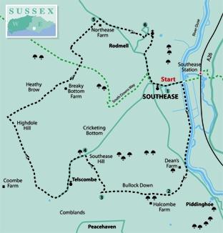
1 - From Southease follow the road eastwards across the valley. Just short of the swing bridge over the River Ouse – recently renovated at a cost of well over a million pounds – turn right to follow the Ouse riverbank for over a mile downstream, with the river on your left, to join the Lewes-to-Newhaven road.
Cross the road and follow the signed bridleway opposite which bears left, squeezing to the left of a pair of iron gates to follow an unmade access drive along a valley.
2 - After about half a mile, at a waypost, turn right through a gap in a neatly trimmed beech hedge and head half-left across pasture, climbing gently. Go through a bridle gate and continue to climb obliquely up the slope, within and then along the top edge of a public open access area of patchy scrub.
Go through a bridle gate and across the field corner to another gate, from which a path winds through scrub. Feed into and follow a concrete track, passing to the right of houses and small paddocks on the northern edge of Peacehaven.
3 - About 50 yards past the last house on the left, turn right through a swing gate and follow a well-trodden path down through scrub within a detached area of Telscombe Tye, open for public access. It is well-used by local people but not shown as open for public use on OS maps and therefore little known to walkers from further afield.
Descend steeply into a valley and climb straight up the other side. Trodden paths proliferate but you should take as direct a route up the hill as practicable, towards the top entering thick scrub, through which a narrow path winds, leading you up and down to join the Southease-to-Telscombe road.
4 - Turn left and follow this lane down into the secluded village of Telscombe, passing the church, with its 12th-century tower and partly Norman interior, and the Youth Hostel.
Follow the lane up out of the village until, about 30 yards past a cattle grid, you should fork right at a finger post. After another 20 yards, at a waypost, fork right again across open downland, aiming for a bungalow.
Go through a bridle gate next to another cattle grid, forward to pass through a similar gate and on with a fence on your left and subsequently on your right, across high undulating downland with wide views, southwards to the coast.
Follow this fine downland path for over a mile. Disregard the first gated and signed path to the right and, after another quarter of a mile, turn right through a gate and head squarely out over open downland, following a faint path over a low summit and down to a gate in a crossing fence.
Through this gate, go forward with a fence on your left, feeding into a farm track which takes you down through Breaky Bottom and up again, passing a small vineyard on your right.
Cross the South Downs Way and follow the track ahead (“White Way”) down to join the Newhaven-to-Lewes road at Northease.
5 - Turn right, where there is a narrow but usable verge on the right to keep you off this busy road. After about 300 yards, turn left through a gap beside a double gate and follow a path across a field, aiming a little to the right of the stubby spire of Rodmell Church.
On the other side of the field, go ahead past a tennis court, over steps in a wall and on across a grassy area and between houses to join Rodmell village street. Turn left.
6 - After 50 yards, turn right along the path to the church. Although much restored, it has an unspoilt charm, much of the structure dating from the 12th and 13th centuries, including the squat pyramidal spired tower.
Walk along the right edge of the churchyard, cross steps in a flint wall, go ahead along a track for a few yards, then fork right along a fenced path, passing to the left of a nicely converted barn. Continue along a track.
Just short of the road, turn left along a signposted permissive path. Created after much hard work by local residents, support from land-owners, and financial help from local parish councils as well as the South Downs Joint Committee and the South Downs Society, this path provides a valuable off-road pedestrian link between Rodmell and Southease for local walkers. You will appreciate it too as a pleasant contrast to the nasty section of road encountered earlier in the walk at Northease.
Parallel to, but well segregated from the road, it takes you back to Southease and the start of the walk.
Allow time to have a good look at Southease Church, beautifully set on a mound overlooking the small village green and notable for its striking round tower, one of three Sussex churches with similar towers situated in a direct line along the Ouse valley, the other two being at Piddinghoe and St Michael’s in Lewes.
* Distance/Time: eight miles/four hours
* By Car: Start from Southease, approachable by car only from the Newhaven-to-Lewes C road to the west. No vehicular access is possible across the railway from the A26 to the east. Road verge parking is practicable in several places between Southease village and the River Ouse crossing.
* By Public Transport: Train to Southease on the Lewes-to-Seaford line.
* What’s underfoot: All along good paths or tracks.
The route between points 3 and 4 is not marked on maps as a right of way or open access. Several ups and downs.
* Thirsty Work: Abergavenny Arms at Rodmell near the end of the walk.
* So you don’t get lost: OS Explorer 122.


Comments: Our rules
We want our comments to be a lively and valuable part of our community - a place where readers can debate and engage with the most important local issues. The ability to comment on our stories is a privilege, not a right, however, and that privilege may be withdrawn if it is abused or misused.
Please report any comments that break our rules.
Read the rules here