
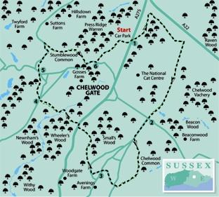
1 - From the Churlwood forest car park entrance, turn right and, after a few yards, turn left along a path which starts between three wooden posts and heads out across the open forest heathland, curving left to head northwards.
Just short of a covered reservoir, double sharply back to the right (not squarely right), still along a clear forest track, now heading generally south-east. At a meeting of five ways at GR 425309, go ahead.
After a little over 100 yards, at a T-junction, turn right to follow a wide straight ride southwards, once an airstrip, one of two constructed in 1941 and 1943 to allow damaged aircraft to make an emergency landing during the Second World War.
After almost a mile, where the track curves right, fork left past a green horse sign, descend to enter woodland and cross a wide stream bridge. Go ahead uphill, ignoring a path off to the left, pass beneath an ornamental stone arch and follow a fenced path out to the road at Chelwood Common.
2 - Cross the road and follow Stone Quarry Road, ahead. Just short of the next road junction, turn left along an access drive, signed as a public footpath. Where this ends, go ahead along an enclosed path to a gate.
Now veer slightly right on a trodden path which drops downhill across a sloping paddock, past a waypost and on to a gate from which a well way-marked woodland path continues.
On the other side of the wood, turn right past a house and follow the access drive from the house out to a road. Cross the road and follow the lane opposite.
3 - At a road junction next to the Coach And Horses pub, go straight ahead and, at another road junction, turn right. Ignore the first signed path to the left and, after another 150 yards, turn left along a path which enters woodland, descending to a stile.
Cross a culvert and, after five yards, fork right up through woodland. Go straight over a crossing track and continue up between banks, then along a right field edge to a road where you should turn right.
After 70 yards, go left over a stile beside a gate and follow a path downhill through woodland. Leave the wood and maintain direction, dropping down across part of a golf course.
Cross a stream, the Danehill Brook, climb to leave the wood and turn left along the top wood edge. After 100 yards, bear right at a finger post and follow a path through trees and past more of the golf course.
Descend to another stream crossing and climb along the right edge of a paddock to a stile. Skirt to the right of a house and follow the drive from the house out to a road.
4 - Cross the road and follow the road opposite, signposted to Twyford. Just past Elm Cottage on the left, fork left along the left edge of a small green to join and follow a drive.
Pass to the right of a grassy island and immediately, at a finger post, fork right along a narrow tree-lined path. Beyond a stile, turn right for 30 yards to join a lane and turn left.
5 - After a few yards, at a road junction, go ahead along Twyford Lane and, after ten yards, squeeze to the left of a locked gate and follow another woodland path which eventually slants down to rejoin the road where you should turn right.
Descend to cross a ford and, after another 200 yards along the lane, turn sharply back to the right along a hard-surfaced track. After about 100 yards, at a waypost, fork right along a path which runs within the right edge of Stumblewood Common, never far from the left edge of this wooded area, and crossing a footbridge en route.
Over a second footbridge, climb steeply, soon with a prominent earth bank on your left.
This is a remnant of the “pale”, which, surmounted by a wooden fence, once enclosed the 23-mile perimeter of the royal hunting park of Ashdown Forest, punctuated by “hatches” or “gates” which are still indicated in some of the local place names.
Follow the path as it continues past a house and garden on your right to join a road where you should turn left.
6 - When opposite the first gateway to a large house on your right, Birchwood House, the family home of former Prime Minister Harold Macmillan, turn left along a wide driveway.
Follow this drive as it skirts to the left of a cricket ground before heading out on to the open heathland of Ashdown Forest as an unfenced track.
Keep to the main track as it eventually curves right and subsequently left to bring you back to the Churlwood car park where the walk began.
* Distance/Time: Six and a quarter miles/three and a quarter hours
* By Car: Park in the Ashdown Forest car park labelled Churlwood which can be found on the west side of the A275 road, about a quarter of a mile south of Wych Cross at GR417310
* By Public Transport: Hourly weekday bus service from Haywards Heath to Chelwood Common, joining the walk near point 2
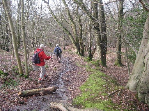
* What’s underfoot: A fairly up-and-down walk using forest rides and woodland paths.
* Thirsty Work: Coach and Horses pub at point 3
* So you don’t get lost: OS Explorer 135


Comments: Our rules
We want our comments to be a lively and valuable part of our community - a place where readers can debate and engage with the most important local issues. The ability to comment on our stories is a privilege, not a right, however, and that privilege may be withdrawn if it is abused or misused.
Please report any comments that break our rules.
Read the rules hereLast Updated:
Report this comment Cancel