
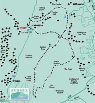
1 - From Jevington village car park, walk out to the village street and turn left, soon passing the seasonally open Jevington Tea Garden on your right, then turn left along Church Lane as far as Jevington Church.
The church, partly Saxon in origin with flint walls and an ancient tower, is beautifully set among trees and is typical of many downland churches in the area.
Walk through the churchyard, passing to the right of the church, pass through a centrally-pivoted tapsell gate and follow a path to rejoin and follow the village street.
2 - When opposite the Eight Bells pub on your left, turn right up steps and follow a path, part of the Wealdway, steadily up on to the Downs. Where the trodden unfenced path divides, keep left up to a stile on the skyline and on along the summit ridge of Combe Hill where you can wander freely as this is a public open access area.
There are views in all directions from this impressive summit, notably northwards into the Weald.
Once past the highest point, fork left on a path which takes you through a shallow dip and on to reach the car parking area at Butt’s Brow.
Pass through two swing gates, skirting immediately to the right of this car park, and go ahead along or parallel to the main track ahead.
3 - At a meeting of four ways where you will find, next to the path, an old boundary stone labelled Eastbourne Old Town, you have a choice.
For the shorter walk, turn right, picking up the walk description where the longer circuit returns to this point, past a metal pole barrier and downhill towards Jevington.
For the longer walk, turn left with the South Downs Way, signed on a waypost to Eastbourne and Beachy Head. A new view soon opens out ahead towards Eastbourne and, on a clear day, along the coast as far as the Dungeness power station. Keep parallel to the fence on your right.
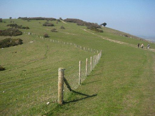
4 - After a little over half a mile go right over a stile in this fence, next to a gate, and follow the fence on your right down to a stile and on along the open grassy floor of Eldon Bottom.
Curve left to reach a stile, next to a gate in a crossing fence, from which a path continues along the valley beside a right-hand fence. Follow this fence as it curves right to a stile from which a path continues, now with a fence on your left, soon veering left to contour along the lower slope on the right side of the valley.
5 - After about 300 yards, fork right for 70 yards, up across grass to reach the fence on the edge of the built-up area of East Dean. Turn sharply back to the right and climb steadily with this fence, separating the downland from gardens and houses, on your left.
Beyond the last house, side-step to the left through a bridle gate and resume your previous direction, now with a fence on your right, soon passing a telecommunications mast.
After about half a mile, go through a bridle gate; turn left for 40 yards to a T-junction with a wide track where you should turn right with the village of Jevington, your final destination, in view down in the valley to your left.
6 - After another half a mile, follow the track as it curves right over the summit ridge of Willingdon Hill, passing a sparse tree clump on your right. After a few more yards, just short of a gate, turn left along another clear track, walking parallel to a right-hand fence.
Through another gate, go ahead, ignoring a right fork, soon along or beside an unfenced rutted track.
Go through a gate, back at point 3 where the shorter walk rejoins the longer circuit. After ten yards, turn left past a pole barrier (this will be a right turn if you are tackling the shorter walk only) and follow the South Downs Way on a clear track down the hill towards Jevington.
Near the bottom of the hill go right over a stile, down a steep bank, then veer left to reach a gate to the right of a white-walled cottage from which a lane leads out to Jevington village street. Turn left for the short distance back to the start.
* Distance/Time: Three miles (appx one and a half hours) or seven and a half (four hours), depending on chosen route
* By Car: Start from the village of Jevington on the unclassified road linking the A259 coast road at Friston with the A27 near Polegate. Park in the village car park at the southern end of Jevington (GR 562013)
* By Public Transport: Frequent bus service along the coast road to East Dean, half a mile off the described route, joining the longer walk at point 5
* What’s underfoot: Excellent walking, all along good paths and tracks. One long steady climb up to the fine viewpoint on Combe Hill and a second ascent on the longer route only
* Thirsty Work: Eight Bells pub at Jevington
* So you don’t get lost: OS Explorer 123


Comments: Our rules
We want our comments to be a lively and valuable part of our community - a place where readers can debate and engage with the most important local issues. The ability to comment on our stories is a privilege, not a right, however, and that privilege may be withdrawn if it is abused or misused.
Please report any comments that break our rules.
Read the rules hereLast Updated:
Report this comment Cancel