
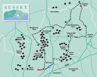
1 - From the junction of Street End Lane and Magreed Lane at GR603225, start the walk northwards along Magreed Lane. Just short of a new house gateway, turn right along the drive to Priors Farm.
Follow this drive as it curves left past a bungalow where a view opens out northwards towards the hilltop village of Mayfield. Just past a stile on the left (not for you), leave the drive by forking left alongside a left-hand fence, gradually losing height.
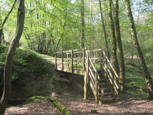
In the field corner go forward over a footbridge and ahead along the left edge of two fields with a stile between them. About 60 yards into the second field, go left over a stile into woodland and down to cross a new footbridge, offering a great improvement on the last time we passed this way on an Argus walk, back in 2002, when it was necessary to scramble across a deep ditch.
A well trodden path continues through the wood where, shortly, you should fork right at a waypost. Keep to the main path on a fairly level path through the wood. Go straight past another waypost and after a few yards, go left down steps, over another footbridge and up to leave the wood.
2 - Head out across two fields with a stile between them, climbing to a bridle gate, in sight, close to the top corner of the second field. A path continues through trees, crossing a drive next to a sawmill entrance.
Go over a collapsed stile and descend along a right field edge. Cross a stile in a dip, where the path is a bit rough and overgrown, and climb within the right edge of woodland. Go over a stile and forward across grass.
Just short of a second stile, not for us, turn right along a left field edge. In the field corner, cross a stile beside a gate and walk along a valley, following the right field edge with a wood on your right.
Go through two gates, sandwiching a stream crossing, and ahead, between widely spaced fences at first, then uphill with a fence on your left.
After passing beneath power lines, veer slightly right across a field, still climbing steadily, to pick up and follow a left-hand fence as it skirts to the right of a tree-shrouded pond to reach a stile.
Over this stile, turn right to cross a field, contouring along the hillside and passing to the right of an area of woodland to join Scotsford Road through a gate. Turn right.
3 - After 40 yards, go left along the drive to Little Pigstrood. After about 100 yards, fork left and, after another 60 yards, go left over a stile, right to a stile beside a gate and on beside a garden fence. Beyond the garden, veer slightly right to find and cross a stile in a hedge then descend with a high hedge on your right. Climb, without change of direction, through trees where there is no defined path. Cross a field, skirt to the right of a tree-shaded pond, then on across a second field to join a drive opposite a cottage and turn left.
4 - After about 300 yards, go ahead through the gateway to Little Stonehurst Farm, pass between the buildings to a gate and go ahead, dropping down into the Rother valley. At the bottom, pass through a gate and walk straight ahead, disregarding another right of way which veers left from this point.
Go ahead through a gate, half-right across the next field to a footbridge, then half-left across the field beyond to a second footbridge, across the River Rother. Cross two more fields with a gate between them, aiming for the buildings of Froghole Farm.
5 - Enter the farmyard through a gate and immediately turn sharply right along a farm track, following a signed bridleway for almost a mile, along the track at first, then within a narrower enclosed path which finally feeds into a lane.
After 300 yards along the lane, turn right at a cross- roads. This No Through Road becomes an access drive. Follow the signed bridleway when it turns left past sheds, passes through trees and then turns right, downhill, along a right field edge, then on along a clear path.
6 - About 60 yards after passing beneath minor power lines, turn left along a signed woodland path. After about 60 yards, sidestep to the left over a stile and resume your previous direction, now with a fence on your right.
Cross a footbridge, turn right over a stile, descend to cross another footbridge and climb to a T-junction with a wider path. Turn left for 40 yards to leave the wood through a bridle gate and head diagonally out across the middle of a field.
Go through a gate in a crossing hedge and forward along a left field edge, following it as it curves gently right.
In the field corner, go through a gate and immediately turn right along a wide woodland track, ignoring other paths.
Follow this clear track through Black Sand Wood, following it round to the right and out to join a lane where you should turn left.
At a road junction, turn right along Street End Lane back to the start.
* Distance/Time: Six and a quarter miles/three hours
* By Car: Start from Broad Oak, east of Heathfield – not to be confused with another Broad Oak, north of Hastings. Roadside parking is possible in various places along Street End Lane which runs along the northern fringe of the settlement
* By Public Transport: Scanty bus service along the A265. For details, consult Traveline on the internet
* What’s underfoot: Field and woodland paths, generally well maintained but not always clearly signed. Care with navigation is needed in several places
* Thirsty Work: No refreshments on the route
* So you don’t get lost: OS Explorer 136


Comments: Our rules
We want our comments to be a lively and valuable part of our community - a place where readers can debate and engage with the most important local issues. The ability to comment on our stories is a privilege, not a right, however, and that privilege may be withdrawn if it is abused or misused.
Please report any comments that break our rules.
Read the rules here