
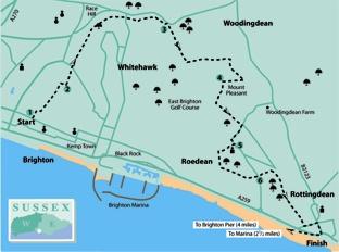
1 - Start the walk along Walpole Road which heads north from Eastern Road at GR 323040, immediately to the east of Brighton College. Follow the road as it bends right, ignore Walpole Terrace, a turning to the left, and, after a few yards, go left along a public footpath, signed on a lamp post which starts as an access road but soon narrows to a path.
Climb steadily, ignoring side and crossing paths. Just short of the point where the path feeds into an estate road, turn right, steeply up a bank. Go straight over a crossing path and on to pass immediately to the right of the end of Brighton Racecourse with a radio mast a few yards to your right.
2 - Shortly, turn left along a wide track with the racecourse on your left.
Cross a road and continue along a wide, grassy path along the ridge of Whitehawk Hill with the racecourse still nearby on your left. You have a choice of parallel paths across this fine open-access area.
Within this area, managed as a Local Nature Reserve, are traces of a 5,000-year-old Neolithic camp, one of the oldest of such sites in Britain.
Cross a road, immediately adjacent to the racecourse at GR 338056 and continue with the racecourse nearby on your left. The area to your right, at the upper end of Sheepcote Valley, was once a council rubbish tip but is now gradually returning to nature and is another public open access area.
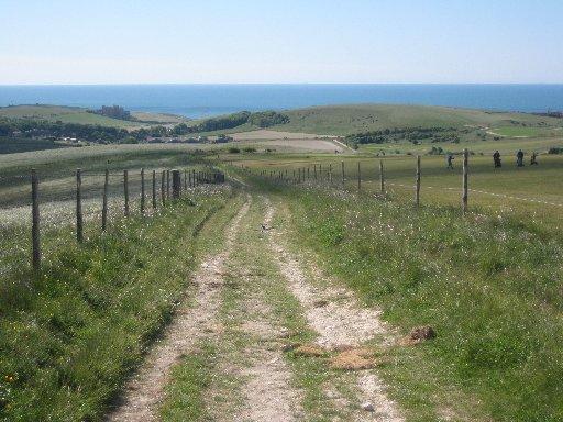
3 - After another half a mile, turn left through gaps in the racecourse railings, right across a small car park, over the low-slung centre of a gate and forward along a fenced path with the racecourse and subsequently a golf course on your right and a fine view ahead to the coast.
After about half a mile, turn left at a waypost and follow a left-hand fence down into a valley (Wick Bottom). At the bottom of the hill go through a bridle gate and straight ahead up the other side of the valley, ignoring paths to the right and left and passing a neat cairn of flints, on a useful permissive route established by Brighton and Hove City Council.
At a T-junction, turn right along a wide path which contours along the hillside. After about 350 yards, turn right along a path which crosses the summit area of the modest hillock of Mount Pleasant. At the highest point on the path, the trig point on the top is in view to the left of the path.
4 - Nearing the bottom of the hill, turn left through a bridle gate, and follow another permissive path along a left field-edge.
The area of grass and scrub on your left is another open-access area. If you’re feeling adventurous, you might like to divert into it through a gate on the left, rejoining the described route through another gate, further along the permissive path which turns left through a gate and heads along the hillside with a fence to the right.
Follow this path out to a road next to a road junction at Ovingdean and turn right, downhill. At the bottom of the hill follow the road round to the left.
5 - After 60 yards, turn right along the access to Ovingdean Church. This lovely little flint-walled church, superbly situated on the side of the hill and surrounded by trees, dates from the 12th century.
To continue the walk, just short of the church lych gate, go right up steps, over a stile and climb steeply with the churchyard wall on your left. Once over a stile at the churchyard corner, continue steeply up across pasture.
At the top of the hill, go over a stile and immediately turn left with a fence on your left, heading for the sea. In the field corner, with the buildings of Roedean School in view over to your right, go left over a stile and forward along a right field-edge.
Towards the bottom of the hill, side-step to the right through a bridle gate and resume your previous direction, now along the left edge of two fields out to a road.
6 - Cross the road and follow the road opposite (Beacon Hill). Opposite house No 29 on your left, turn right through a gate and veer half-left up on to and along the ridge of Beacon Hill, another fine open-access area.
After about two thirds of a mile, pass to the left of Rottingdean Windmill and on to a road where you should turn left down into Rottingdean.
For the church, village green and the fine old houses surrounding it, turn left along the village street.
To complete the walk, turn right out to the coast road and a bus back to Brighton.
If you would like a longer walk, head west from Rottingdean along the coast, either along the clifftop or the undercliff path as far as Brighton Marina, increasing the length from five and a half to eight miles and on along the promenade to Brighton Pier for a total of nine and a half miles in all.
* Distance/Time: Five and a half miles/two and a half hours. Extended walk: Eight miles to Brighton Marina, nine and a half miles back to Brighton Pier (up to five hours for longest option).
* By Car: Not recommended. Car parking is difficult near the start.
* By Public Transport: Bus to Brighton College from the centre of Brighton for the start and bus back from Rottingdean or other points along the coast at end of walk. Frequent service.
* What’s underfoot: Excellent walking all the way on good paths. Several hills, none steep except a short but sharp climb out of Ovingdean. The walk includes two short permissive link paths not marked on older OS maps.
* Thirsty Work: Pubs and tea rooms at Rottingdean. Several sources of refreshment along the coastal extension.
* So you don’t get lost: OS Explorer 122


Comments: Our rules
We want our comments to be a lively and valuable part of our community - a place where readers can debate and engage with the most important local issues. The ability to comment on our stories is a privilege, not a right, however, and that privilege may be withdrawn if it is abused or misused.
Please report any comments that break our rules.
Read the rules here