
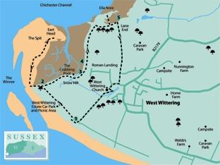
1 - Walk across the wide area of grassland and picnic sites adjacent to West Wittering beach to the far western end – the sandy beach away to the left is probably too soft to push a buggy over, although it would be possible at low tide on the firmer sand.
At the far end of the grassed site locate the railing fences that mark the limit of the parking area, this is half a mile from the entrance to the wide, grassed car park and picnic site. In front is the East Head spit. Under the care of the National Trust, this is an area with popular sandy beaches beyond the gorse bushes, where the dunes are made up of shingle and sand, all held together by the rare coastal plants and marram grass.
There is an abundance of wildlife for such an exposed location and it is sometimes possible to see common and grey seals. Influenced by tidal movement, the dunes have shifted over time, from facing west to their northerly position today.
There are boardwalks across the dunes and it is just about possible to explore with a baby buggy. You can gain access to the beach at low tide and walk across the firmer sand, but you will need to return to the railing fences, mentioned above, in order to resume the expedition.
2 - Locate the gap in the low railing fence, close to scrub, and turn right from the grassed car parking area, north-eastward, on the enclosed footpath that passes through a copse. Keep to the path, which emerges from the trees and continues north-east, with the tidal inlet off to the left.
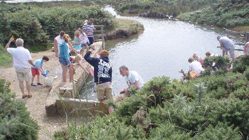
After a quarter of a mile the footpath turns to the right and comes to Snow Hill, an area of flooded creeks and ponds. In a few yards the path arrives beside the designated crabbing pool and this is the spot for some experimental hunter-gathering. You will need a bucket, weighted fishing line, a small landing net and some bait – bacon is recommended. It is possible to sit on the wall to the left, or descend right to the larger pool, where seats allow viewing of the gladiatorial contest between hardy fisher folk and creatures of the deep. Take great care with children in this area.
3 - With a catch fit for a feast, return to the main path, turn right to climb a short ramp and then turn left on a raised path above the inlet, where boats are stored on the sheltered beach to the left.
In about 200 yards, with scrub on the left, the path comes to a wide green, with houses away to the right. Maintain direction and walk to the far side of the green, arriving beside a four-way footpath sign. Take the path that goes to the quarter-left, re-entering the scrub and passing beside an area known as Roman Landing (they probably came for the crabbing).
4 - The path continues north, passing beside wind-stunted oaks and recently planted alder among the dense scrub. There are open fields on the right, taking advantage of the rich soil of the coastal plain that has been, for many centuries, fertile agricultural land.
After a quarter of a mile the path arrives at a right turn, beside a bird hide and still within the scrub cover. In a further 250 yards a footpath sign indicates a left turning and by dropping to the beach level it is possible to explore, if tidal conditions permit, the spit of Ella Nore. All of the coastal creeks and inlets are a favourite stopping off point for migrating birds.
Return to the main path, resuming the earlier direction and, in 100 yards, come to a bridle gate and three-way junction at Lane End.
5 - Turn right along Ella Nore Lane and keep to this for a little over half a mile, passing a scattering of houses and allotments, to arrive beside a house called Rosemary at Pound Road in West Wittering.
Turn right along the road, which is the old village street, passing period houses and drawing alongside the local primary school. Opposite the school is the parish church of St Peter and St Paul, which is well worth further investigation. A church has been at this delightful setting since before the original Saxon wooden structure of the eighth century was destroyed by Viking invaders and was subsequently rebuilt in stone.
Return to the village street from the churchyard and turn right, passing the school and local houses and coming to a road junction. Cross to the opposite pavement and turn right, following the path as it enters the grounds of the West Wittering Estate.
Keep to the straight path for about one third of a mile and pass around the entrance gates to the grassed parking area; the beach is off to the left. Follow the appropriate route back to find your parked vehicle.
* Distance/Time: Three-mile baby buggy walk, taking two hours. Add one mile/one hour if you take the East Head option, plus time for crabbing.
* By Car: South from the A27, Chichester bypass, on to the A286, signed “The Witterings”; from the roundabout in Birdham follow the B2179 and signs for West Wittering. Parking on West Wittering Estate beach car park – fee payable. Start point GR SU772979, from entrance to West Wittering Estate parking area.
* By Public Transport: Travel details from www.traveline.info, phone 0871 2002233. Bus 53 from Chichester Rail Station to Rookwood Road, West Wittering. Walk south-west, turn right into Pound Road and follow directions from section five of the walk description.
* What’s underfoot: Level coastal walking, no hills. Can be done with an off-road baby buggy or baby backpack.
Take care with children beside water.
* Thirsty Work: Refreshment facilities at start/finish on the beach car park. Taking a picnic seems a good idea. The Old House At Home pub in West Wittering.
* So you don’t get lost: OS Explorer map 120, plus a compass for general direction


Comments: Our rules
We want our comments to be a lively and valuable part of our community - a place where readers can debate and engage with the most important local issues. The ability to comment on our stories is a privilege, not a right, however, and that privilege may be withdrawn if it is abused or misused.
Please report any comments that break our rules.
Read the rules here