
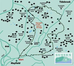
1 - From Mayfield village car park, return to the High Street and turn right, soon following it round to the left. Shortly, go right into the entrance to the village hall and recreation ground.
Follow a path along the left edge of the recreation ground, pass immediately to the left of a football pitch, descend steps in a hedge, cross a track and go over the stile opposite.
Now turn right to follow a path along a right field-edge, soon crossing a drive and dropping down, close to the right edge of sloping pasture. Feed into an enclosed path, continue along a right field-edge and then down through more woodland, ignoring side paths.
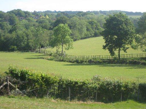
At the bottom of the hill, go ahead over a substantial concrete footbridge, fork right over a stile beside a gate. Climb along the left edge of rough pasture, continuing without change of direction across the middle of two large fields, the second one peppered with small oak trees.
2 - Join and follow a right-hand fence with a wood on your right. Disregarding two stiles into the wood on your right, go ahead, now following the newly dedicated right of way mentioned in the walk introduction and not yet marked on the Explorer map.
Cross the remains of a culvert in a dip and immediately bear right to follow the right edge of a large hayfield, dotted with planted trees with a wood close by on your right.
After about 350 yards, go right over a stile and follow a wide track across a culvert. After a few yards, at a T-junction, turn right. Just short of the wood edge, ignoring the squeeze stile ahead, go left through a bridle gate, through a wood to a similar gate and on across a field to join a lane through a third bridle gate. Turn left.
From this lane you get good views back towards Mayfield through gaps in the hedge on your left.
3 - Just short of a road junction, turn right over a stile and head slightly left downhill across a large hayfield. (If the grass is long, the headlands to right or left, may, if mown as they were when I checked the walk out, provide easier alternative routes.) Go over a stile at the far end of the field, and on along a right field-edge. A wooden gate on the right provides public access to some old mine pits, by courtesy of the Countryside Stewardship Scheme.
Continue along the right field-edge for 100 yards, then turn right through the second of two gates on your right.
Now head half-left across a field, descending to a gate in the bottom corner from which a farm track continues. Follow this track past Highfields Farm and where the main track bends left, go ahead to a gate and on along a right field-edge.
Follow the field-edge round to the left and, at the bottom field corner, turn right through a gate, forward along a right field-edge, then right and left, following a well-trodden and signed bridleway which skirts to the right of two large ponds, managed as a nature reserve.
The bridleway feeds into an access drive from cottages and takes you out to the road at Tidebrook where you should turn right.
4 - After about 300 yards, go left over a stile, right behind the roadside hedge to another stile, then left with a post-and-rail fence on your left. Where this fence turns away, go slightly right across the field to find a hidden stile into a wood.
Walk through the wood and in the same direction across a meadow. Go over a footbridge and head squarely across a field to join the right edge as it rounds a corner.
Go through a gateway near the top field corner and go ahead, joining and following the right edge of the next field and following it as it curves round to the right. Go through a gate in the corner and forward across a field to another gate.
5 - Continue between the buildings at Cinderhall Farm where the farmhouse incorporates an elegant converted twin oast. Follow the drive from the house to a T-junction, and turn right.
After a quarter of a mile, at another junction, turn left to follow a drive laid with concrete sleepers, some still with metal rivets in place, gently downhill with good views. After about two thirds of a mile, at a third T-junction, turn right and, after 60 yards go left, downhill, still along a concrete track.
At the bottom, go ahead over a footbridge and bear right along a woodland path, beside a stream at first, then curving left, uphill. Go straight over a signed crossing path. After leaving the wood a well-trodden path follows a left field-edge.
In the field corner, go ahead over a stile, ignoring the one on your left. After a few yards, where you have a choice of trodden paths across a field, go ahead, ignoring the right fork. From the other side of the field, an enclosed path continues behind gardens and out to join an estate road.
Turn right. At a road junction, turn right again and, at another junction, turn right once more. After a few yards, just past the Rose And Crown pub, go left along a tarmac footpath which takes you behind houses and alongside the recreation ground, back into Mayfield – a village worth exploring if time permits.
* Distance/Time: Seven miles/three and a half hours
* By Car: Start from the village of Mayfield, accessible from the village bypass on the A267 Heathfield-to-Tunbridge Wells road about four miles north of Heathfield. Park in the village car park, signposted down a narrow lane from Mayfield High Street.
* By Public Transport: Bus from Heathfield or Tunbridge Wells to Mayfield.
* What’s underfoot: An undulating route along mainly well-defined and signed paths.
* Thirsty Work: Pubs at Mayfield and towards the end of the walk at edge of village.
* So you don’t get lost: OS Explorer 136


Comments: Our rules
We want our comments to be a lively and valuable part of our community - a place where readers can debate and engage with the most important local issues. The ability to comment on our stories is a privilege, not a right, however, and that privilege may be withdrawn if it is abused or misused.
Please report any comments that break our rules.
Read the rules here