
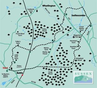
1 - Whether arriving by bus, train or car, make your way to the town centre next to the Battle Abbey gateway at GR 749158 and start the walk eastwards along the main street walking on the pavement to the left of the road.
After a few yards, just short of the parish church, turn left, downhill, along an access drive, feeding into a path which squeezes to the left of a Scout Hall. Over a stile, go ahead dropping down across a sloping meadow to join the left edge.
Go over a footbridge in a wooded dip, cross another small field to reach a drive through a metal swing gate and turn right.
2 - After less than 100 yards, turn left, immediately bearing right through a gap to climb along a left field-edge. Follow the field-edge round to the right and shortly, in front of a large white-walled house, go left through a wide gap and follow a trodden path across the middle of a field.
Go through a gap a few yards to the left of the top field corner and bear right along the right edge of an area planted with young trees. At the far end of this area, go through another gap and along a right field-edge.
At a junction with an unmade track, turn right, passing to the right of a cottage. Follow this track, which becomes a tarmac drive.
3 - After about a quarter of a mile, cross a bridge over the railway and, after 60 yards, turn left through a narrow metal gate.
The field path from here is undefined and requires careful navigation. Head half-right down across a field, passing immediately to the left of a power pole and beneath two sets of power lines.
On the other side of the field go through a narrow overgrown gap a few yards to the right of a wider gap, emerging into a field corner. Head out across the next field, diverging very gradually from power lines and go through a wide gap in the next hedge about 20 yards to the left of the point where the power lines cross the hedge.
Now go forward with a high hedge on your left, walking roughly parallel to power lines. In the field corner, go left along a narrow path which burrows through the hedge and then head half-right across another field to find a stile in the next hedge about 60 yards to the right of the bottom field corner.
Go ahead between horse paddocks, past a small stable and on along a drive to join a road. Turn left.
4 - Shortly, where the road bends right, go ahead along a gravel drive. Where the drive ends, go forward along a narrow path, skirting to the left of a house and garden to enter Petley Wood, soon with a high deer fence on your left.
Where the path ends at a stile, go forward for 20 yards. Just past a large building on your left, fork left along a narrow path which drops down between banks, soon merging with a wider path within the right wood-edge.
Shortly, fork left along a grassy path, with the deer fence still on your left.
After about 200 yards, at a three-arm sign, turn sharply right, soon with the deer fence briefly on your right.
Go over a footbridge and squarely across a field to seek out a footbridge in the overgrown hedge opposite.
Continue along the left edge of a neglected ploughed field, rough underfoot, to join the A21.
5 - Cross the road, go through the bridle gate opposite, and head half-left up across pasture, crossing a mown air strip. On the other side of the field, go right through two bridle gates and follow a fenced path downhill. Cross a valley beside a left-hand fence, passing a pond, not yet marked on OS maps.
Go over a footbridge and climb, following a gated, waymarked path through three fields. In the third field veer slightly left, down to join a road along a short path to the left of a house and garden.
Turn right to walk into and down through the village of Sedlescombe, passing the Queen’s Head pub and the village green.
6 - At the bottom of the hill, just past the Bridge Garage, turn right along an access drive, soon feeding into a path beside a small children’s playground. Cross two footbridges and continue with a deep ditch on your left.
Sidestep left over this ditch, follow a winding path through grass and scrub, over two more footbridges and across a field. Recross the A21 and follow the drive opposite, signed to Battle Great Wood.
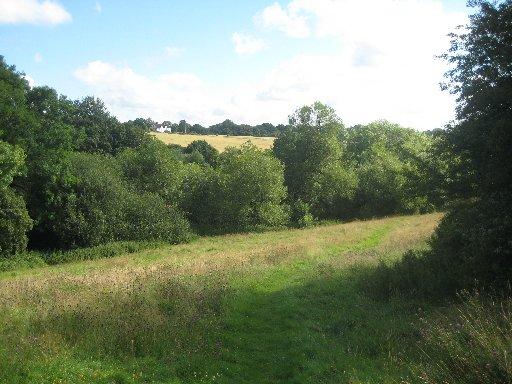
At a T-junction in front of a large house, turn left. Just past a large storage shed on your right, turn right through a yard to a gate and on along a meandering left field-edge, using a neatly mown path. Enter Battle Great Wood and continue unmistakably to reach a junction with a wide forest ride.
Turn right to follow this fairly straight track, labelled as part of the 1066 Country Walk, westwards through Great Wood for almost a mile, ignoring all side and crossing paths. Join a road and bear left to follow it back into Battle. There is a narrow path on the nearside verge at first, then a good pavement. Cross the railway, join the main road and follow it to the town centre, walking beneath the Abbey walls.
Allow time to explore this historic town and for a visit to the site of the Battle of Hastings and the Abbey which William the Conqueror established to commemorate his victory. Both are open daily.
* Distance/Time: Six and a half miles/three and a half hours.
* By Car: Start from Battle on the A2100 about five miles north-west of Hastings. The main town car park is at GR 748160.
* By Public Transport: Bus or train to Battle from Hastings
* What’s underfoot: An undulating walk along field and woodland paths, occasionally rough underfoot. Route finding needs care across fields between points 3 and 4.
* Thirsty Work: Queen’s Head pub at Sedlescombe. Choice of pubs and cafés at Battle.
* So you don’t get lost: OS Explorer 124


Comments: Our rules
We want our comments to be a lively and valuable part of our community - a place where readers can debate and engage with the most important local issues. The ability to comment on our stories is a privilege, not a right, however, and that privilege may be withdrawn if it is abused or misused.
Please report any comments that break our rules.
Read the rules here