
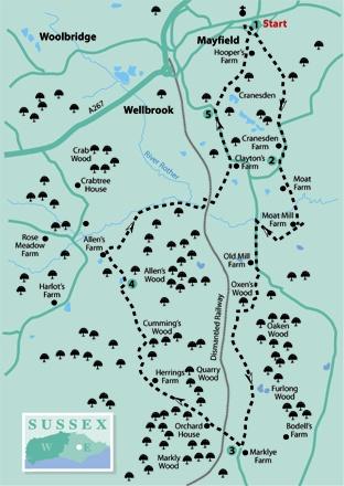
1 - From the entrance to Mayfield village car park, turn left along a lane and, after a few yards, left again along a narrow path which tunnels down between banks to join another lane. Go straight ahead here along a lane which becomes an access drive.
Where the drive divides, keep right (more or less straight on), shortly feeding into a wide path between fence and hedge which continue through woodland, down to a stream crossing. Emerging from the wood, follow the top edge of pasture to join and go ahead along a lane.
2 - After about 350 yards, turn left over a stile, follow a fenced path to a second stile and carry on along the right edge of three successive fields. Go over a footbridge, across a field to a gate and forward beside a post-and-rail fence to a wicket gate.
A path continues to a swing gate, then turns right beside a high hedge. Shortly, join and go ahead along a gravel drive which passes to the left of a fine old oast conversion at Moat Mill Farm.
Where the drive divides, fork right and, at another junction, fork right again, over a stile beside a gate and head diagonally across a field to join a road where you should turn left.
After about a quarter of a mile, follow this road round to the left and, after a few yards, turn right through a gate, set back from the road, along a path signed as a cycle route to Heathfield.
This generally dry and well-surfaced path now heads south for over a mile through a pleasant mix of woods and fields. After about half a mile, at a junction with a wider track, turn right, pass a bungalow on your left and shortly ignore a left fork, continuing along the hard-surfaced track for another half a mile.
3 - At GR 586227, when opposite a stile on your left, turn right along a gravel drive where, shortly an impressive view opens out towards Mayfield. Follow a signed diversion as it skirts to the left of a house and garden then drop downhill along a left field edge to a stile and footbridge at the bottom and on along a woodland path.
Go over a wide crossing track, cross another footbridge, leave the wood and climb across two fields to reach a drive in front of the elegant red-brick farmhouse at Herring’s Farm.
Go ahead through a gate immediately to the right of the house and drop steeply downhill across a field to a gate from which a fenced-off headland path continues, soon bearing left down between tree-lined banks.
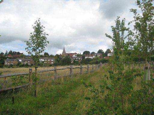
Cross a footbridge and follow an indistinct woodland path as it bears right. Leave the wood and head squarely out across a large undulating field where there is no defined path. At a finger-post on the other side of the field, turn right, joining and following a left field edge with a glimpse of Mayfield Church through the trees ahead.
4 - Shortly in the field corner, go left through a swing gate, cross a small meadow to a gate and drop downhill within a hollow way, overgrown in places. Go forward between the buildings at Allen’s Farm and, a few yards short of the farmhouse, turn right entering and following a wide, tree-lined grassy path.
After about 200 yards, go left through a double gate, bear half-right across a field to a gate and continue across the next field, veering slightly left to reach a farm gate in the far left corner (not the more obvious bridle gate to the left of the corner).
Beyond a narrow gate in the next corner, a fenced headland path continues. At a T-junction with a wider track, turn left and follow it round to the right and through a bridge beneath the old railway, part of the so-called Cuckoo Line. Now bear left to follow the drive from a large house to a road and turn left.
5 - After about a quarter of a mile, turn right along a signed path which follows a high, right-hand fence through trees and along the right edge of two fields. Cross a drive and follow the right edge of a third field with Mayfield now in clear view.
Your stiled and waymarked path continues unmistakable through a wooded dip and up between fields, partly within a strip planted with young trees, finally squeezing between houses to join a lane.
Turn left and shortly right along a narrow path through to another lane, then right again for a few yards back to the start.
Mayfield is worth exploring if time permits. Be sure to include a stroll along the length of the characterful village street, which is lined by many old buildings, including several dating from the 16th century.
The parish church, although much altered, originated in about 1420. Iron grave-slabs, built into the church floor, are a reminder that the village was once at the centre of the Wealden iron-smelting industry.
* Distance/Time: Seven miles/three-and-a-half to four hours
* By Car: Start from the village of Mayfield on the A267 north of Heathfield. Park in the village car park, signposted down a narrow lane from the High Street at GR 587269
* By Public Transport: Bus from Tunbridge Wells or Heathfield to Mayfield
* What’s underfoot: A fairly hilly walk, mostly along well-defined paths. Reasonably dry underfoot
* Thirsty Work: Pubs and tea rooms at Mayfield, none on the route
* So you don’t get lost: OS Explorer 135


Comments: Our rules
We want our comments to be a lively and valuable part of our community - a place where readers can debate and engage with the most important local issues. The ability to comment on our stories is a privilege, not a right, however, and that privilege may be withdrawn if it is abused or misused.
Please report any comments that break our rules.
Read the rules here