
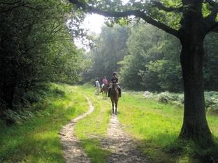
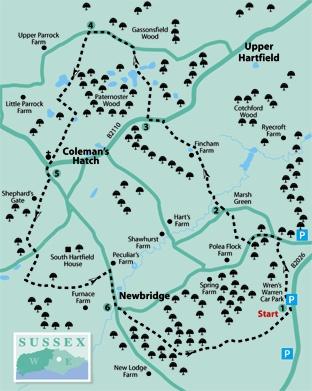
1 - Start the walk past a wooden pole barrier at the back of the Wren’s Warren car park and follow a grassy track to a junction next to a memorial seat where a fine view opens out westwards and north-wards across Ashdown Forest.
Turn right by the seat to follow a wide forest track gently downhill. Where this track curves round to the right, go ahead along a narrower grassy path, feeding into the access drive from a large house. Follow this drive out to a lane.
To visit Pooh Sticks Bridge, turn right here as far as the Pooh Bridge car park from which a path leads to the bridge, returning the same way but adding a mile to the length of the walk. However, to continue the described walk, turn left along the lane.
Shortly, ignore a right fork and after another 200 yards, turn right through the entrance gate to White House Farm. Go forward along the house drive to find a stile to the right of a shed, built into a low wall.
Go right for 30 yards to a conventional stile, then half-left across a meadow to a third stile. Descend steps and turn right along a neglected concrete drive. Shortly past a gate, go left through a narrow wicket gate and head diagonally right across grass to join a lane through a similar gate.
2 - Follow the unmade drive opposite, passing a large house called Hopswood on your right and soon entering a narrower path. Cross a stream footbridge and follow a well-trodden path which winds ahead across open ground and up a bank.
Where the path opens out into an area planted with young trees and you have a choice of signed paths, fork left along the left edge of this area. In the corner, go through a gate and across grass, passing to the right of a tennis court and a garden.
Go over two stiles and turn left across a field corner to a third stile to join a drive. Turn right, follow this drive out to the B2110 and turn left.
3 - After a little over 100 yards, immediately past the elaborate iron gateway to The Pond House, turn right along a fenced path which squeezes between gardens. Where the path opens out, go squarely ahead across two fields with a gate between them, through another gate and half-left across the middle of a third field.
In the field corner, where you get a glimpse of an attractive lily pond through the trees to your left, one of several similar ponds in the area, go over a stile beside a gate and forward along a well-trodden path through trees and scrub to join Parrock Lane over a stile and turn left.
4 - After about 350 yards, just past a stream crossing, go left along a path signed with a stone plinth.
This narrow path skirts to the left of a large pond. Where the path divides, fork right to a gate, emerging into a field.
Follow the left field edge to another gate, and then veer half-right uphill across a second field. In the corner, go over a stile and keep along the right edge of the next field as it curves right with a post and rail fence and another pond on your right.
Go through a bridle gate close to the next field corner, through a strip of woodland, then half-left on a visible cross-field path. In the corner, go through a gate and, disregarding the stile ahead, veer half-right across a field to another stile in the far corner.
A woodland path continues, over a footbridge and on between banks, to join a road next to Coleman’s Hatch church. Follow the road opposite (Shepherd’s Gate).
5 - If in need of refreshment, the Hatch Inn is now about a quarter of a mile along this road, returning the same way. However, to continue the walk, after 100 yards only, just short of a telephone box, fork right along a tarmac drive.
Where it divides, go ahead, signed as a No Through Road to Shepherd’s Gate. Where the drive ends at a house entrance, go ahead along a wide grass strip, soon entering woodland. At a wide crossing track, turn left out to a road.
You now have a choice of two driveways opposite and yours is the one on the right, signed to various properties. Just past a house called Skinningdale on your left, fork left with the house hedge and garden on your left.
The path then passes along the left edge of a cricket ground and continues through a typical Ashdown Forest landscape of mixed trees and heathland, eventually merging with a drive which takes you on to a road. Turn right.
6 - At the bottom of the hill at Newbridge, turn left along Chuck Hatch Lane, crossing a ford or the bridge alongside it. After less than 100 yards, turn right past a wooden pole barrier and on along a wide forest path which soon starts to gain height.
Follow this path on a well-graded climb through trees. Emerging into the open, follow the main track as it bears left and subsequently right, still climbing. Keep with the track as it heads towards the recognisable tree clump on Gill’s Lap.
About 200 yards after parting company with more dense woodland on your left, turn left along another wide, level track, heading generally north-east, a magnificent open traverse with wide views northwards.
Follow this track straight back to Wren’s Warren car park.
* Distance/Time: Five and a half miles/two and a half hours
* By Car: Park in the Ashdown Forest car park labelled Wren’s Warren on the east side of the B2026 road about three miles south of Hartfield (GR 470326)
* By Public Transport: Weekday hourly bus service from Crawley, East Grinstead or Tunbridge Wells to Coleman’s Hatch, starting the walk from point 5
* What’s underfoot: Mostly along good paths or tracks. Navigation across Ashdown Forest requires care as not all the paths used are marked on the Explorer map and there are many alternatives to lure you off the described route
* Thirsty Work: Pub at Coleman’s Hatch, about a quarter of a mile off the route
* So you don’t get lost: OS Explorer 135


Comments: Our rules
We want our comments to be a lively and valuable part of our community - a place where readers can debate and engage with the most important local issues. The ability to comment on our stories is a privilege, not a right, however, and that privilege may be withdrawn if it is abused or misused.
Please report any comments that break our rules.
Read the rules here