
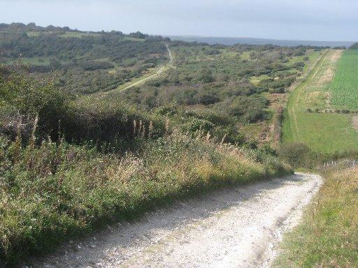
1 - From the stop for westbound buses next to the car park and opposite the entrance to the Seven Sisters Country Park Centre, a useful source of local information, cross the A259 and start the walk along the South Downs Way, signed to Alfriston, passing to the right of a flint building housing a Cycle Hire Centre, through a gate and up a grassy slope.
At the top, pause to look back over the oxbow meanders of the old Cuckmere River to the sea at Cuckmere Haven. Go through a bridle gate, over steps in a flint wall and ahead through woodland.
After 60 yards, turn right along a level woodland path signed with a red arrow but not indicated on the Explorer map. Follow more red arrows, ignoring other paths, fairly soon joining a wide path, running parallel to but well insulated from the A259 road, a few yards away to your right.
Shortly, where the red arrow path goes left down the hill, continue ahead along the wide level path, parallel to the road. Go ahead, ignoring a left fork and subsequently go straight across a drive coming in from the A259.
2 - After another quarter-mile, at a crossing path, signposted from the road a few yards to your right as a public footpath, turn left to follow a narrower path down through the wood. Go straight over the first crossing path, soon curving gently right.
Go over another crossing path, designed for adventurous cyclists and, at a T-junction with a wider path, turn right. Follow this terraced path and, after about a quarter of a mile, at a waypost with a yellow arrow, fork left.
Drop down, soon with a flint wall on your right, join a drive and go ahead, passing two large cottages and a large pumping station. Disregard the first signed bridleway to your left. Where the drive veers right, go ahead along a path and, after a few yards, just short of a pole barrier, fork left and follow a path steeply up through the wood.
Emerging from the wood, continue up across an open area of grassland used as a gallop.
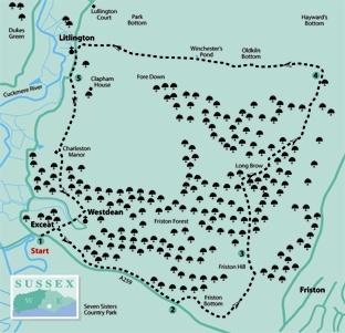
3 - Re-enter Friston Forest. This 2,000-acre area of broad-leaved woodland was first planted in 1926 to protect the water catchment area for Eastbourne. It is criss-crossed by a complex network of paths and tracks, all open for public use on foot. Our described route is mainly along designated bridleways but, armed with a map and compass, you might like to try one of the many alternatives. There is a convenient direct path of sorts outside the woodland, linking points 3 and 4, but, although used by walkers, this is not a public right of way.
After entering the wood, go ahead along a wide track, ignoring side and crossing paths and walking straight ahead across a hard track in a dip, then up a long steady incline on to Snap Hill, labelled on the map but completely shrouded by trees.
At the point where the path levels out, turn right along a wide, unsigned ride. Ignore a narrow crossing path and, at a T-junction in front of a small pond, turn left. Shortly at a Y-junction, fork right and, after 100 yards, join and bear right along a wider rising track, following it to the edge of the wood, once again ignoring side paths.
Out of the forest, turn immediately left along a wide grassy strip with the trees on your left and a wide view to your right across the valley towards Combe Hill and the Downs above Eastbourne.
From the corner of the wood a clear field headland path continues. Where it divides, fork right to pass through two bridle gates and follow a path through an area of trees and scrub.
4 - At a junction, turn left, joining the South Downs Way and soon merging with a wider track where you should bear left. Climb through trees and, at a junction, where the South Downs Way goes off to the right, go straight ahead.
Now follow a clear undulating track generally westwards, passing Lullington Heath Nature Reserve and Winchester’s Pond, a partially cleared and restored dew pond, accessible through a gate on your right.
The track descends into the Cuckmere valley, with a fine view ahead to the village of Alfriston against a back-drop of the Downs rising to Firle Beacon.
Continue down, ignoring a right fork, to join a lane at Litlington. Turn left past the church, Litlington Tea Gardens (seasonal) and the Plough And Harrow pub.
5 - Soon after passing the pub, turn left along a lane and, after a few yards, turn right through a swing gate, now back on the well-signed South Downs Way which you will be following back to the start. It climbs across grass to another gate, continuing along the left and right edges of successive fields before descending into a valley to re-enter Friston Forest over a stile.
Turn left along a path within the wood edge and, shortly, go right up steps and ahead along a wide woodland path. Follow the South Downs Way signs through the wood and right down into the quiet and secluded village of Westdean.
The church and the Old Rectory, parts of which date from 1220, are along the lane to the left and are worth a short there-and-back detour. But to complete the walk, go ahead, passing to the left of the village pond and shortly forward up another long flight of steps. At the top, go ahead over a stile in a flint wall, back on your outgoing route which you can follow down a grassy slope back to the start.
* Distance/Time: Eight miles/four hours
* By Car: Start from the Seven Sisters Country Park using the car park opposite the Park Information Centre on the A259 at Exceat Farm (GR 518995)
* By Public Transport: Frequent bus service along the A259 coast road between Brighton and Eastbourne
* What’s underfoot: A faintly strenuous walk with several ups and downs, mostly along good, well-drained paths or tracks. Careful navigation is required in Friston Forest where there are many alternative paths to lead you astray
* Thirsty Work: Plough And Harrow pub at Litlington (point 5) and tea rooms (seasonal) at Exceat and Litlington
* So you don’t get lost: OS Explorer 123


Comments: Our rules
We want our comments to be a lively and valuable part of our community - a place where readers can debate and engage with the most important local issues. The ability to comment on our stories is a privilege, not a right, however, and that privilege may be withdrawn if it is abused or misused.
Please report any comments that break our rules.
Read the rules here