
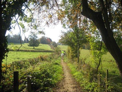
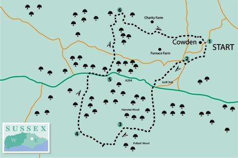
1 - Start the walk along a lane which leaves Cowden village street next to the church and bus stop and heads downhill, with the churchyard on your left. Shortly, fork right along a grassy fenced path which, beyond a gate, passes between allotments, crosses a drive and continues down between hedges.
After a few yards, fork left over a stile beside a gate and, at the edge of a golf course, turn right, passing to the right of a green and soon entering a wide grassy strip between areas of scrub.
Where the path opens out, some care is need as the path is undefined. Turn left for 50 yards to cross a golfer’s bridge over a small stream, pass immediately to the right of an isolated silver birch tree and cross a fairway to enter a path into scrub. Carry on through two gates and out to a lane where you should turn right.
2 - Shortly, at a road junction, turn left along Furnace Lane and, after 70 yards, turn left up steps to follow a clear woodland path. The path emerges and, without change of direction, crosses another segment of golf course before re-entering woodland, signed as a bridleway. Join and follow an access drive which passes to the left of a row of tile-hung and weather-boarded cottages. Follow this drive out to the A264 road.
Cross the road and follow Cansiron Lane opposite. After over half a mile, soon after passing the entrance to Little Cansiron Farm on your left, fork right along a signed footpath which winds through woodland, indistinct and overgrown in places, crosses a footbridge and passes beneath power lines.
Go over a more substantial footbridge and turn right along the right edge of two fields. In the second field corner, go left with the field-edge and shortly right through a hedge gap to head out across the next field, aiming for another visible gap. Follow the right edge of the field beyond.
3 - In the field corner, follow the field-edge round to the left and, after a few yards, side-step to the right over a stile in the hedge and resume your previous direction, uphill along the left edge of two fields. In the second field corner, ignoring the stile ahead, turn right, still along the left field-edge.
In view across the valley to your right is Hammerwood House, built in 1792 in the so-called Greek Revival style and designed by Benjamin Latrobe, who also worked as an architect on the Capitol building in Washington DC.
After about 300 yards, follow the field-edge round to the left, join a farm track over two stiles and turn right. Follow this track down into a valley and up past the buildings of Owlett’s Farm.
4 - After another 300 yards, just past Dog Gate Lodge on your right, fork right along a well-surfaced fenced path, part of the Vanguard Way. After a little more than half a mile, where the Vanguard Way goes off to the left, go ahead along a track to a gate and forward along the left side of a paddock.
In the corner, turn right and, after 60 yards, fork left through a bridle gate and along an enclosed path which takes you out to the A264. Turn right beside this busy road, past the entrance to Hammerwood House and Hammerwood Church, taking care as the road carries fast traffic and the verges are skimpy.
5 - Where the road begins to bend left, fork left along a hard track which you can follow for a quarter mile or so through to a lane, passing a large and picturesque pond.
Cross the lane and follow the concrete track opposite, which becomes a hollow way between high banks. Emerging into a field, follow the left edge round two sides, then go left through a gate and forward along another left field-edge.
In the corner, ignoring the gate ahead, turn right, still along the left field-edge.
In the next field corner, go through a bridle gate and ahead through woodland.
6 - After 60 yards, at a meeting of several ways, go right through a newish metal swing gate, forward through woodland to a second, similar, gate then along a right field-edge, following it round two sides of the field.
In the far corner, go over a stile beside a gate and keep to the left edge of the next field. Go over another stile next to a gate and follow a right field-edge to a third stile/gate combination.
Shortly, where the trodden path divides, fork left along the left edge of rough pasture. Go left through a wood and then right, diagonally across a field, where there is a faintly visible path.
Go ahead down across the next field, into woodland, over a footbridge and up through the wood, bearing right at a path junction. At the top of the hill, leave the wood through a gate and go ahead along the drive from Waystrode Manor.
In view from the drive, over to your right, this impressive half-timbered farmhouse dates from the 15th century with Tudor and later additions. Join a lane and go ahead, following it into Cowden, back to the start.
* Distance/Time: Seven and a quarter miles/three and three quarter hours.
* By Car: Start from the village of Cowden, signposted northwards from the A264 East Grinstead-to-Tunbridge Wells road at Holtye. Roadside parking is possible with care near Cowden church at GR 465405.
* By Public Transport: Scanty and not very practicable bus service to Cowden. Train to Cowden one mile from the start of the walk.
* What’s underfoot: Generally good and easy walking along well-drained tracks and field paths. Some care needed with navigation across golf course near the start.
* Thirsty Work: There is a pub at Cowden.
* So you don’t get lost: Most of the walk is on OS Explorer 147, with a small segment only on Explorer 135.


Comments: Our rules
We want our comments to be a lively and valuable part of our community - a place where readers can debate and engage with the most important local issues. The ability to comment on our stories is a privilege, not a right, however, and that privilege may be withdrawn if it is abused or misused.
Please report any comments that break our rules.
Read the rules here