
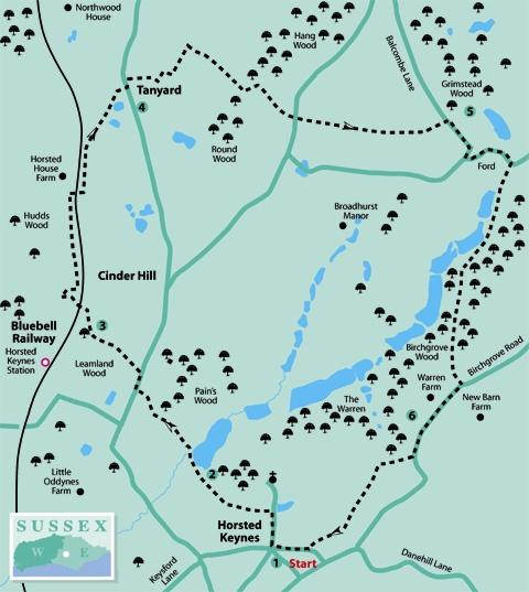
1 - From the western end of the wide grass verge in Horsted Keynes, head for a point on the north side of Station Road, opposite the post office and the entrance to Lewes Road. Locate a descending footway, around bollards, heading north, and walk down to Church Lane.
Turn half-right to continue along the lane that leads to the village church and, at about the halfway point, immediately after a cottage called Timbers, turn left on to a footpath. Go down the sloping path to gates and follow the enclosed route along the shallow valley floor.
The path sweeps to the right, passing beneath trees, with a pond down to the right. On arriving at an abrupt right turn, follow this down to a wider track and turn left for 25 yards.
2 - Take the right fork, leaving the wider track, with a large fishing lake through trees on the right.
Follow the path skirting around the end of the lake (with the option for a diversion to take in the view across the popular angling spot) and pass a weir outlet, continuing to a three-way footpath junction a few yards ahead.
Take the left turn, negotiating a triple-plank bridge and climbing on a narrow path through scrub, up to more level woodland and crossing over a plank bridge. The path clears the woodland after a few hundred yards, continuing across the hillside and descending to the roadside.
Turn right up the road for 100 yards and, with a brick building on the right, turn left across the road, climbing a bank to arrive beside paddocks. The true path-line enters the nearest paddock, going left across rutted ground for 150 yards, through intermediate gates – there are inquisitive horses as well.
The easier alternative is to keep to the edge of Leamland Wood, following the path to meet up with those who have chosen the rodeo route. Cross a stile, then a plank bridge, continuing west, finally passing through a metal kissing gate.
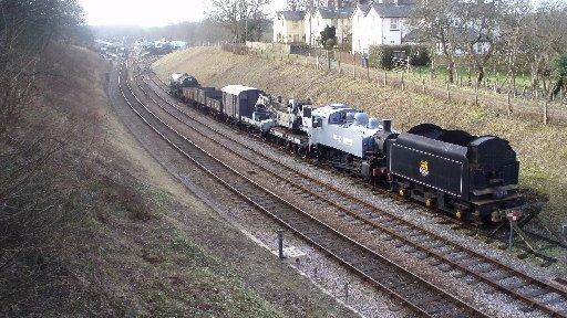
3 - Take a half-right line, crossing a grassy slope on the flank of Cinder Hill, to a parking area on the left, next to a bridge. Cross the bridge, above the Bluebell Line, with views to Horsted Keynes station, and at the far side turn right. Keep to the path, skirt left around a small field to cross a stile, and turn right around a spinney. Cross a second stile in a few yards, turning right up through a young plantation to the edge of the railway line.
Turn left and follow the line-side path for one third of a mile to a three-way path junction, beside a railway crossing. Turn right over the line (making sure it is safe to cross, we want no accidents with Thomas The Tank Engine), cross a stile and turn left to the top-left corner of a meadow.
Pass over a track, with a bridge on the left, and enter a hilltop paddock. Keep to the right field-edge beside a copse, to a field-corner stile. In the next paddock, head for the opposite hedgerow, on a trodden path, and cross a stile. Go left for a few paces and then turn right, passing by workshops and houses at Tanyard.
4 - From the roadside, turn left for 50 yards, crossing to a grass verge and passing through a gate into a field. Turn right down the hillside, keeping right of a small brick barn, to the bottom left corner.
Descend steeply on steps to a stream, on its way to join the River Ouse. Cross a narrow causeway path above a weir – care required on this section, particularly with children.
At the far side, climb a bank, going left up through the woodland to a field.
Turn left up the field edge to the left corner and there turn right across the field. At the left corner, descend steeply to a footbridge, climbing out to a metal kissing gate. Go left for 75 yards, then turn right beside an embankment, climbing to the roadside.
Cross to the opposite stile and into the next field. Follow left field-edges for half a mile, with distant views to the South Downs.
5 - At Balcombe Lane, a minor road, turn right, turning right again in 200 yards. In a further 50 yards, turn left, down the hill. At the bottom of the incline there is a ford, just the place to test if your boots are waterproof. Otherwise, use the bridge on the right.
Walk ahead a few yards and take the first turning on the right, on to a bridleway leading into Birchgrove Wood. The wide track follows a southerly route, with fishing lakes down to the right.
After about one-third of a mile, the track arrives at a fork: take the left-branching bridleway ahead. Climb through the woods to clear the trees and turn left up to Birchgrove Road. Turn right along the road, passing Warren Farm in 200 yards.
6 - Continue along the ridge-top road for a further quarter of a mile to come to a right-turning footpath that crosses a stile on the right, leading towards a water reservoir site. Just before entrance gates to the site, turn right on to a woodland path and, in 100 yards, join a track on the right.
Walk ahead a few yards, going left through a metal kissing gate and taking a half-right line across a level meadow to the opposite hedge-row. Pass through a second kissing gate a few yards right of the left corner, and keep direction across the next field to a third kissing gate.
Cross the final small meadow to another of those affectionately designated gates, continuing on a path beside allotments towards the village hall at Horsted Keynes. Pass by the hall, turning left along the approach drive to the village green and shop.
* Distance/Time: Five and three quarter miles, taking three hours
* By Car: Horsted Keynes is on a minor road (Horsted Lane/ Danehill Lane), west of Danehill (A275), or east from B2028, quarter of a mile north of Lindfield onto Keysford Lane/Station Road, follow signs to village. Start point grid ref: TQ384282
* By Public Transport: Travel details from www.traveline.info. Bus stop close to start point, beside village green
* What’s underfoot: High Weald walking with some short climbs, through woodland and open hilltops, clay underfoot can be very sticky after rain. Possible with a baby backpack; not possible with a baby buggy. Care required with children and animals beside weirs and deep ponds
* Thirsty Work: Pubs beside the green in Horsted Keynes
* So you don’t get lost: OS Explorer map 135, plus a compass for general direction


Comments: Our rules
We want our comments to be a lively and valuable part of our community - a place where readers can debate and engage with the most important local issues. The ability to comment on our stories is a privilege, not a right, however, and that privilege may be withdrawn if it is abused or misused.
Please report any comments that break our rules.
Read the rules here