
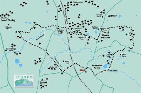
1 - From Barcombe village car park, turn right along the road and, after a few yards, at a mini-roundabout, turn right again. A few yards beyond the new village hall on your left, turn left through a squeeze stile and follow a headland track along a right field-edge.
At the bottom of the hill, go ahead for 70 yards to cross a footbridge over a feeder stream of the Ouse (Red Bridge) and then turn left along a valley, walking parallel to the fence on you right.
At the end of this long field, go through another squeeze stile and immediately fork right, walking gently uphill on a defined cross-field path. Cross a drive, climb steps to a stile and go ahead with a fence and hedge on your left.
After another stile bear left, still with a hedge on your left and a good view across the Ouse valley, and southwards to the ridge of the Downs.
Join a lane and turn right.
2 - Just past the buildings of Delves Farm on your left, turn left over a stile beside a gate. Now some care is needed as the signed and mapped routes don’t agree.
Bear half-left across a field corner to a gateway in a hedge, then veer very slightly left across the next field to pass through another gateway in a dip next to a prominent oak tree. Now go ahead across the next field to pass through a squeeze stile in the right corner, a few yards to the right of a more obvious stile which is a private access to a pond and should be ignored.
Go ahead for 60 yards, pass through a wide gap and then turn sharply right along a right field-edge, following it round to the left and ignoring another private access stile on your right.
3 - In the field corner, turn right over a squeeze stile beside a gate and follow a wide path, enclosed at first, with a wood on your right, then along a right field-edge. In the corner, ignoring the gate ahead, turn left, staying within the same field.
In the next field corner, cross a track and, at a four-arm finger post, go ahead through open woodland (Burtenshaw Wood). After leaving the wood, go forward along the right edge of two fields.
In the second field corner, disregarding the stile and gate ahead, turn left along the field-edge. In the field corner, go right through a gateway and immediately left over a stile to join a tree-lined track. Turn right and follow this track and, subsequently, an access drive out to a road. Turn left.
4 - After about 250 yards, a few yards past a telephone box at Mount Pleasant, turn right along the drive to Knowlands Farm. Walk between the buildings, then on beside and through Knowlands Wood, where the landowner invites public access, though our walk keeps to the right of way.
Pass beneath the old railway to a stile and head out across a field to join a lane in the far-left field corner. Go through a wooden gate, almost opposite, to the right of the entrance to a house called Harelands.
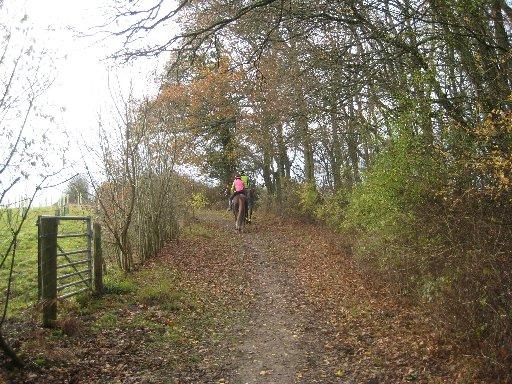
A clear path, trodden by horse’s hooves, takes you through trees, along the edge of woodland, then curving left across a field corner to a gate and on beside a well-trimmed right-hand hedge.
In the field corner, enter woodland and, after a few yards, where the path divides, fork left, following this defined bridleway as it passes the entrance to Balneath Farm and becomes a tarmac drive.
5 - After another 250 yards, where the drive bends right, turn sharply back to the left through an iron gate and along a right field, soon with a wood on your right. Walk along the left edge of rough pasture to a footbridge, cross a field and climb between fences. Join and follow a drive out to a lane and turn right.
After a few yards turn left along a tree-lined track (Birdshole Lane) through to another lane via an access drive. If wet underfoot, an alternative parallel path is available, on the right of the track at first and subsequently to the left.
6 - Turn left along the lane and, after a few yards, go left again along an enclosed path and then the left edge of one field and the right edge of a second, with a stile and footbridge between them.
In the second field corner, follow the field-edge round to the left for a few yards, and then go right through a gap, recrossing the track bed of the old railway which once linked Lewes and Uckfield.
Go ahead across a field to cross a footbridge and then turn right along the right edge of Barcombe recreation ground and back to the village street within a few yards of the Royal Oak pub and the start of the walk.
* Distance/Time: Six miles/three hours.
* By Car: Start from Barcombe, labelled as Barcombe Cross on OS maps, signposted from the A275 road about four miles north of Lewes.
* By Public Transport: Two-hourly weekday bus service from Lewes to Barcombe Cross.
* What’s underfoot: Straightforward walking on field and woodland paths. Minor hills only. Mostly well signed but care with navigation needed after point 2.
* Thirsty Work: Royal Oak pub at Barcombe Cross.
* So you don’t get lost: OS Explorer 12.


Comments: Our rules
We want our comments to be a lively and valuable part of our community - a place where readers can debate and engage with the most important local issues. The ability to comment on our stories is a privilege, not a right, however, and that privilege may be withdrawn if it is abused or misused.
Please report any comments that break our rules.
Read the rules here