
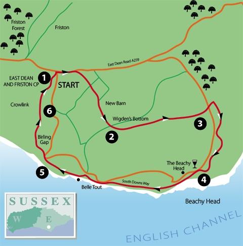
1 - From the south-west corner of East Dean village car park, follow an enclosed path out to the A259 and turn right past the bus stops – your starting point if arriving by public transport. Follow the main road up out of the village in an easterly direction. There is a good pavement on the left side of the road.
After about 300 yards, turn right through a bridle gate and follow a right-hand fence across rising undulating downland. At a signed crossing path, go straight ahead, still with a fence on your right.
Approaching a flint-walled barn (New Barn), the small brick hut in view over to your left was once a shepherd’s hut, in use at a time when the whole area was one vast unfenced sheep pasture.
A few yards short of the barn, veer slightly right through a gate and down beside a right-hand fence to another gate, then continuing downhill, with a fence on your left.
2 - At the bottom (Wigden’s Bottom), go through a gate to join a track, go left through a second gate and then slant half-right up a grassy slope, where there is no obvious path at first. Enter and climb through scrub, now along a clear path.
At a three-armed finger post above the scrub, fork right, signed to Beachy Head, up to the top of the slope. Ignoring a gate and path downhill to your right, follow a path generally westwards along the gradually rising ridge of Long Down.
3 - After a little over a mile, join the B2103 Beachy Head road where a fine view opens out ahead across Eastbourne and, on a clear day, along the coast to Hastings and as far as the Dungeness power station. Cross the road and follow the path opposite.
At a four-armed finger post, turn right with the South Downs Way. At a similar post, where the South Downs Way turns sharply away to the left, go ahead along a signed footpath.
Continue along the hillside, walking parallel to, but some way away from, the road, rejoining part of the South Downs Way as it contours above an area of scrub dropping away to your left.
Shortly curve right, walking parallel to the coastline, high above the sea and soon burrowing into and through the scrub, partially cleared in places. The path hugs the hillside as it climbs very gently up on to Beachy Head.
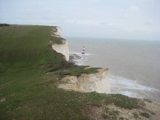
4 - At the top, to the left of the path, there is a safe viewpoint overlooking the lighthouse at the base of the cliff. No longer needed as a daymark, this iconic structure is at risk of losing its striking red and white stripes and will be allowed to fade to grey unless a vigorous local campaign succeeds in raising the money to have them repainted.
From this point, the Beachy Head pub is a short distance inland along the tarmac path to the right. To continue the walk, follow the clifftop path westwards.
At the highest point along the cliff edge, a small brick enclosure marks the site of a former Lloyds signal station, in operation until 1904 and superseded by a larger naval establishment, in use during the Second World War as a radar station.
Continue along the clifftop for more than two miles to Birling Gap, descending at first, then climbing to pass immediately to the landward side of Belle Tout.
In use as a lighthouse from 1832 until decommissioned in 1902 and replaced by a new lighthouse at the foot of the cliffs, Belle Tout occupies a precarious position close to the edge of the crumbling chalk cliffs, though its life was prolonged when, in the late 1990s, the whole structure was raised on hydraulic jacks and moved inland. It is now a hotel.
Approaching Birling Gap you get a good view ahead along the whole length of the Seven Sisters towards Cuckmere Haven and Seaford Head. The café/bar here is managed by the National Trust.
5 - From Birling Gap, leave the car park through the main entrance, turn left and immediately fork left again, uphill along the unmade access drive to a group of bungalows. Beyond a gate, the drive becomes a track where you can bear right, soon ignoring the coast path, which goes off to the left.
Emerge on to the open National Trust access land of Crowlink. You can wander freely over this large area of open downland but our walk goes straight ahead along a signed bridleway to a gate and on across open pasture.
Pass about 60 yards to the left of a flint-walled barn with a bright red roof. Once past the barn, drift gradually right towards an area of scrub over to your right, joining and following the scrub edge.
6 - At a waypost, feed into a path that drops obliquely down through scrubby woodland with East Dean now in sight ahead.
Follow the path down to join a lane that takes you on into East Dean village.
Turn right along the right edge of the village green.
Pass between the Tiger Inn on your left and tea rooms on your right, back to the car park and the start.
* Distance/Time: Seven and a half miles/three to four hours
* By Car: Start from the village of East Dean on the A259 coast road between Seaford and Eastbourne. Park in the village car park, signed from the road to Birling Gap at GR 557978
* By Public Transport: Frequent bus service along the A259 coast road between Brighton and Eastbourne
* What’s underfoot: A fairly strenuous walk, all on clearly indicated paths or across open downland. Several ups and downs
* Thirsty Work: Pubs at East Dean and Beachy Head. Tea rooms at East Dean. Café and bar at Birling Gap
* So you don’t get lost: OS Explorer Map 123


Comments: Our rules
We want our comments to be a lively and valuable part of our community - a place where readers can debate and engage with the most important local issues. The ability to comment on our stories is a privilege, not a right, however, and that privilege may be withdrawn if it is abused or misused.
Please report any comments that break our rules.
Read the rules here