
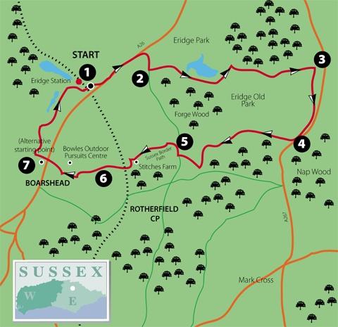
1 - From the entrance to Eridge Station, turn left and, opposite the Huntsman pub, fork right and immediately right again along the drive to The Lodge. Pass beneath the A26 and immediately fork left along a signed cycleway, a wide path running parallel to but well segregated from the A26.
After about half a mile, the track feeds into a lay-by, joins the main road verge for a few yards and then diverges again as a lane. At a road junction, turn right.
2 - At the bottom of the hill, cross a stream, turn left over a stile and follow the left edge of three fields with the stream on your left. After the third field, go over a stile and turn right, now on an enclosed path, part of the well-signed Tunbridge Wells Circular Walk and the High Weald Landscape Trail, which you will be following for over two miles.
Follow it through woodland and left across a large field, on or beside an unfenced track with a large lake in view over to the left. On the other side of the field, cross a stream and bear left within the right edge of woodland, with a high deer fence on your right.
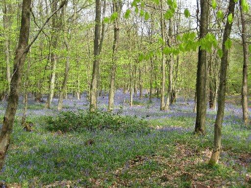
This fence, which will now accompany you on and off for several miles, encloses Eridge Old Park, reputed to be one of the oldest enclosed deer parks in England and containing more than a thousand of these shy animals.
Beyond a gate in this fence, go left along the edge of another lake to a footbridge and swing gate, then right, now on a clear track with the lake still on your right at first.
After the best part of a mile, at a notice with a map showing permissive access within the park, go straight ahead, ignoring a path off to the left. Shortly, go through a swing gate and ahead, soon across more open grassland.
3 - Go through a gate in the deer fence, where there is another access notice, and turn right, now following a permissive path, shown on the notice but not indicated on the Explorer Map.
It is partially marked with white waymark arrows, along a clear path at first, then less distinct through woodland, never far from the deer fence on your right and gradually converging on a road, away to your left as it gains height.
Cross the drive to an isolated house and continue up through the wood. At another drive, turn right and, after a few yards, just short of a cattle grid, go left along a faint path through bracken.
4 - Shortly, go right through a gate in the deer fence and head out across high open parkland, passing two isolated trees and then veering gradually left, downhill, to join and follow the deer fence, now on your left.
Ignore the first gate, in this fence, continuing roughly parallel to the fence, now on the occasionally way-marked Sussex Border Path, which you will be with until Boarshead.
Follow yellow arrows left over a stream, through a gate in the deer fence, up through woodland and out to a lane, finally between widely spaced fences. Turn right and, at a road junction, right again along Sham Farm Road.
5 - Just short of the entrance to a house called Stonewall, turn left over a stile to follow a right field-edge. From the field corner, follow an enclosed path left and, after less than 100 yards, go half-right along a cross-field path to join a left-hand hedge and bank.
Where the hedge ends, veer slightly right across a field to join and follow a hedge on your right down towards farm buildings at Stitches Farm. Go through a gateway and shortly skirt round to the left of the buildings to join a track.
Go over the stile opposite, forward for 50 yards, then left downhill along a left field-edge. Pass beneath the railway and go half-right past planted trees to a wide farm bridge and then uphill between fences, with a wood on your left, to join a lane.
6 - Go right for five yards only, then left through a kissing gate and along a right field-edge, with views over the hedge to the right towards the dramatic sandstone cliffs at the Bowles Outdoor Centre, which also offers a dry ski slope.
In the field corner, go through a gap and follow a track left and right towards farm buildings. Skirt to the right of the buildings (Rocks Farm) to join and follow the access drive from the farm out to join a road, the end of a cul-de-sac section of the old A26.
7 - Turn right to follow a path that ramps down from the end of the road to cross the A26. At the top of the ramp at the other side of the road, turn left to follow a tree-lined access drive. Ignore a left fork to continue downhill between high sandstone banks.
Just past the entrance to Renby Grange on your left, go left over a stile and resume your previous direction to enter a deep, hollow way. At a finger-post, where the Sussex Border path goes off to the left, go ahead along a track.
Where this track bends right towards farm buildings, veer half-left across a field to join and follow a left field-edge to a stile and then an enclosed path which takes you out via the drive from a large house to join a lane. Turn right and, at a road junction, left, back to Eridge Station.
* Distance/Time: Nine miles / four hours
* By Car: Start from Eridge Station, signed from the A26 Crowborough-to-Tunbridge Wells road about three miles north of Crowborough (fee payable) (GR 542346). Alternative free parking at end of cul-de-sac of old A26 at Boarshead (point 7 – GR 535330)
* By Public Transport: Train to Eridge Station on Uckfield line or bus from Tunbridge Wells, Uckfield or Brighton along A26 past start of Eridge Station access
* What’s underfoot: Generally good going along clear paths or tracks, mostly well-signed. Several ups and downs
* Thirsty Work: Pubs at Eridge and Boarshead (half a mile off the route)
* So you don’t get lost: OS Explorer Map 135


Comments: Our rules
We want our comments to be a lively and valuable part of our community - a place where readers can debate and engage with the most important local issues. The ability to comment on our stories is a privilege, not a right, however, and that privilege may be withdrawn if it is abused or misused.
Please report any comments that break our rules.
Read the rules hereLast Updated:
Report this comment Cancel