
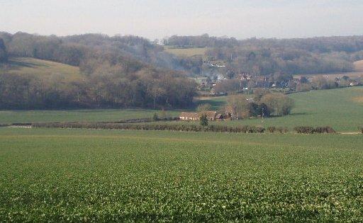
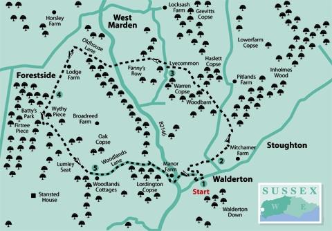
1 - From the main street in Walderton, a few yards north-east of The Barley Mow pub, turn into Cooks Lane, passing by a stream gully that carries the River Ems through the village. Climb beside houses and turn left in 100 yards. In 125 yards, along the top village street, locate and take an enclosed footpath on the right, leading to a field-edge. From this position, where big arable fields come into view, turn right along the field-edge, passing by a left turning in a short distance, and continuing for 200 yards to pass right through a hedge opening. Resume direction to the top left corner of the next field. On arriving at a minor road, cross to the opposite side and join a rising field-centre path.
2 - At the top of the field pass through a gap in the hedgerow and continue up the field along a left hedge-row. In 150 yards the path leaves the hedgerow and keeps direction up the hill, bearing slightly left towards the woodland that is 350 yards ahead. Enter the tree cover of Inholmes Wood and from a three-way junction, just inside the wood, turn left on a bridleway, crossing open meadow after 200 yards and walking down a right hedgerow to a minor road. Cross to the opposite woodland of Woodbarn, passing metal gates and climbing the wide track, ignoring a left turn after 200 yards. In a short distance the path levels-off, following a north-westerly line on a wide track, with half-left, then half-right turns, at the mid-way point, but generally maintaining direction – Haslett Copse is on the right.
As the bridleway leaves the shelter of the woodland, continue ahead on a track bordered by oak trees and between fields, to a remote three-way junction at Lyecommon – there is a cottage off to the right, amongst the trees. Turn left, following the bridleway to the roadside, passing by Warren Copse and ignoring a left turning.
3 - Turn right up the road for 75 yards and then turn left through an opening on to a mid-field path that heads for 375 yards to the narrow woodland strip of Fanny’s Row. Descend ahead through the narrow strip of woodland. On clearing the tree cover there are delightful views off to the right, towards West Marden village. Continue down the hillside on the tree-bordered path, to a road. Cross to the opposite road, Oldhouse Lane, and climb for half a mile, passing a left-turning bridleway after 200 yards and another bridleway as you near the top of the climb. When the road levels off, continue to a hedgerow junction with a bridleway and footpath, and turn left around a gate on to a wide track that leads to Lodge Farm in 250 yards. Keep direction between the farmhouse and farm buildings, avoiding the clucking hens and cockerels. Continue over the next wide fields, heading for the distant woodlands of Wythy Piece and Batty’s Park.
4 - At the edge of the woodlands is a crossing footpath, keep to the bridleway and enter the tree cover ahead. There is coppiced woodland on the right and mature trees on the left. The bridleway comes to a junction of bridleways and footpaths after a little more than a quarter of a mile. Step back from the path sign a few paces and take the footpath (yellow arrow) that goes to the left, still in the woodland. (Resist the temptation to continue on the bridleway that turns half-left, a few yards ahead.) Follow the footpath through the woods for about 100 yards, as it bears to the right in a short distance, to arrive at a metal kissing gate at the edge of a field. Pass through the gate and take a half-left line, on a trodden path across the field, dropping into a shallow bowl, passing through a kissing gate, then climbing to a fence corner beside woodland. Turn right and follow the path that skirts around the edge of the woodland, bearing left and in a further 250 yards, having passed a pine plantation, arriving at a surfaced drive. Cross the drive, following the ongoing path into scrub and rhododendron cover to a stile, continue over a narrow meadow to the edge of a wide, arable field – the grounds of Lumley Seat are off to the right.
5 - Follow the trodden path across the field, taking a south-easterly line to the far field corner. On arriving at a junction of tracks and paths, turn left, passing around metal gates, on to Woodlands Lane. Follow the quiet surfaced lane that sees little traffic in a generally eastward direction, taking a few intermediate turns and rise and fall but keeping to the metalled surface. After three-quarters of a mile the road turns right and descends to pass by houses at the edge of Walderton and arrive beside a minor road (B2146) – there are more houses away to the right.
Cross the road to the opposite verge and turn left for 100 yards to a junction with Cooks Lane. Turn right into the lane, climbing to a right turn and, in a further 75 yards, bearing left. Keep to the lane that soon comes to the turn-off we were at the start of the walk. Continue to the next right turn and descend the hill to our starting point, close to where the River Ems runs beside the road.
* Distance/Time: Six-and-a-quarter miles, taking three hours.
* By Car: Walderton village is on a minor road that leads off the B2146 and is about five miles west of Chichester. There is roadside parking in the village. Start point grid ref SU791107.
* By Public Transport: Travel details from www.traveline.info, phone 0871 2002233. Buses from Chichester bus station to Walderton.
* What’s underfoot: Some easy climbs and descents in the western South Downs across open fields and in woodland. Possible with a baby backpack, not possible with a baby buggy.
* Thirsty Work: The Barleymow pub in Walderton.
* So you don’t get lost: OS Explorer maps 120 plus a compass for general direction.


Comments: Our rules
We want our comments to be a lively and valuable part of our community - a place where readers can debate and engage with the most important local issues. The ability to comment on our stories is a privilege, not a right, however, and that privilege may be withdrawn if it is abused or misused.
Please report any comments that break our rules.
Read the rules here