
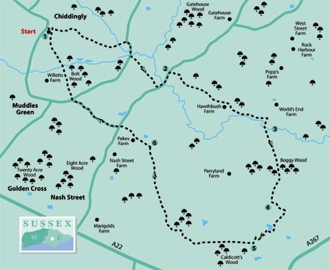
1 - From the entrance to Chiddingly Village car park, turn left along a lane with the church to your right. After a few yards, go left through a bridle gate and bear right to follow the right edge of two fields, then on between hedges before feeding in to an access drive which takes you out to a lane. Turn right.
2 - After about 200 yards, turn left into the start of the drive to Willow Farm and follow an enclosed path which starts through a squeeze stile to the right of a high wooden gate and skirts to the right of the property.
Where this path opens out, go ahead with a hedge on your left, following the left field-edge out to join another road over a stile and turn left.
After about 200 yards, turn right through a gap in the hedge where there is a yellow arrow on an old gate post. Head squarely out across rough pasture, pass immediately to the right of a belt of trees protruding into the field from the left and veer very slightly left across a field corner to go through a wide gap.
Without change of course, follow the direction of a yellow arrow on a waypost across a large cultivated field where, at the time of writing, the path may be ploughed and planted without reinstatement.
Go through another wide gap in the next, tree-lined, hedge and cross the next field, aiming immediately to the left of the buildings at Hawthbush Farm where you can join and follow a hard track, veering right and left between the buildings.
Once out into a field, head for the far-left corner, cross a footbridge and go ahead, walking parallel to the right edge of rough pasture. Cross another footbridge in the corner and go ahead within a wide grassy strip. After passing through another gap, turn right along a field-edge to cross another substantial footbridge.
3 - Some care is now needed as the route from here is difficult to follow accurately. Head half-left across a large cultivated field (the directional footpath sign is misleading at this point). After topping a rise, head for a point in the line of woodland ahead about 100 yards from its left-hand end.
If you have hit the right spot you will find a footpath sign and sleeper bridge hidden in the undergrowth at the edge of the wood.
From here make your way generally south through the aptly named Boggy Wood, a messy area scarred by a primitive vehicle race track.
The public footpath is undefined but there is a sort of way through. Emerging into a field after about 200 yards at or near another finger post, once again misleadingly orientated, turn right to follow a track along the right field-edge, ignoring another signed path off to the right.
4 - On reaching a wide- crossing track, signed as a bridleway, turn left. After about 200 yards, go through a double gate, join a tarmac drive on a bend and turn right. Where this drive ends, skirt to the left of an anglers’ pond and go ahead across a cultivated field.
On the other side of the field, turn right along the field-edge for a few yards, then left over a footbridge and ahead for 60 yards.
5 - Join and turn right along a delightful, spacious, tree-shrouded bridleway, continuing to join and follow the drive from a house, keeping on it as it turns to the right.
At a T-junction with another drive turn right. After ten yards only, fork left and, almost immediately, turn left along a narrow signed footpath with a high perimeter fence enclosing an industrial area on your left.
Soon after parting company with this fence, at a signed footpath junction, turn right through trees, continuing along the left edge of the first field and the right edge of several more to reach a T-junction with a farm track.
6 - Turn left and follow this track past various buildings at Pekes Farm and on to join a road at Thunder’s Hill. Continue along the road, almost opposite, signed to Muddles Green and Chiddingly.
At the next road junction turn right, and, after 30 yards, go left along a signed footpath. Follow this clear path, signed and stiled throughout, back to Chiddingly, reaching the village through the recreation ground and churchyard.
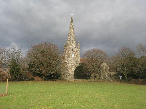
The church has an unusual stone spire, one of only four in Sussex. At 128ft in height, it is a prominent landmark, visible for several miles around the village.
* Distance/Time: Five and a half miles/two and a half hours.
* By Car: Start from the village of Chiddingly which is signposted northwards from the A22, a short distance east of Golden Cross. Park in the village car park next to the church at GR 644142.
* By Public Transport: None convenient.
* What’s underfoot: A walk without hills, mostly along field and woodland paths. Some challenges to navigation where paths may be ploughed and planted without reinstatement and a compass could be useful. One short undefined section through Boggy Wood after point 3.
* Thirsty Work: Six Bells pub at Chiddingly.
* So you don’t get lost: OS Explorer 123


Comments: Our rules
We want our comments to be a lively and valuable part of our community - a place where readers can debate and engage with the most important local issues. The ability to comment on our stories is a privilege, not a right, however, and that privilege may be withdrawn if it is abused or misused.
Please report any comments that break our rules.
Read the rules here