

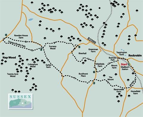
1 - From Wadhurst Station entrance, turn right beside the road. After about 200 yards, fork right along a signed footpath, now on the patchily waymarked Sussex Border Path which you will be following for the next few miles.
Descend to cross the railway, climb across a field and continue through woodland until you can merge with an access drive and follow it out to join a lane. Turn right.
At a road junction, go straight ahead along the drive opposite. After about 350 yards, when opposite a large house on the left, turn right through a bridle gate and drop down along a left field-edge veering left to find and cross a footbridge in a wooded dip.
Climb with a stream on your right, go through a bridle gate and follow the lower edge of two sloping fields with a wood on your right before bearing right over a footbridge. Climb through the wood to a swing gate and then bear left parallel to the left field-edge, ascending to join a lane.
2 - Turn left and, after about 100 yards, turn right through a gate, follow a fenced track to a swing gate and continue, walking parallel to the right edge of two fields and the left edge of a third field, punctuated by swing gates.
A path then drops steeply through woodland, aided by steps, crosses two stiles and continues to join a lane where you should turn right.
After about 200 yards, a few yards after crossing a stream, fork left along a woodland path which climbs between sandstone banks, passes through a bridle gate and continues along a right field-edge.
Through a gate, bear right for a few yards, then left along a track, following waymarks through the buildings at Earlye Farm. Leave the farm area through a bridle gate and drop downhill, walking parallel with a left field-edge.
A path descends to a footbridge in a wooded dip and climbs steeply along the right edge of two fields to a bridle gate, from which a short hedged path leads out to a drive on a corner.
3 - Just short of the drive, you will come to a four-armed finger post. If omitting the loop out to the A267, turn right here. For the full walk or to link with the previous Argus walk of May 19, turn left at the finger post, go through a bridle gate, and head squarely out across a field. On the other side of the field, you have a choice of two gates ahead and yours is the one on the left.
Keep to the right edge of two fields and on in the same direction, walking parallel to the right edge of a third field. Go through a gate a few yards to the left of the field corner and maintain your direction along the right edge of two more fields.
Cross another field and pass immediately to the left of a large storage shed. Cross a farm yard at Pococksgate, go left through a double gate and follow the access drive from the farm out to join the A267 road.
To join up with the first of the pair of linked Argus walks, go ahead along the Sussex Border Path which continues through bracken to a gate in a deer fence, almost opposite. But to complete today’s walk, turn right beside the main road.
4 - After about 100 yards, turn right along a drive which becomes a farm track and eventually narrows to a path. At a lane turn right and, after another 300 yards, back at the finger post at point 3, follow the drive round to the left.
Shortly, go ahead through two gates and drop downhill on a grassy path between banks. At the bottom of the slope, bear right to a gate and go ahead with a high hedge and bank on your left. Pass to the left of a wooden building, go through a gate and carry on with a hedge on your left.
In the far bottom field corner, go through a bridle gate and left along a well-waymarked woodland path which eventually narrows between banks and takes you out to a lane. Turn right.
5 - After about 150 yards, turn left over a stile beside a gate, go forward along a track for 40 yards, and then right along a narrower winding woodland path which you can follow over a footbridge and on through patchy grass and trees.
Pass to the right of a long disused tennis court with an elaborate thatched pavilion, a relic of Riverhall, country estate of the Fowle family, created from the profits of the local iron industry. The woods and parkland, like the tennis court, are now in a state of melancholy but picturesque neglect.
The path, well-trodden and waymarked, passes through an old gateway, crosses a footbridge, winds through trees, climbs to a stile and continues along the left edge of two fields to join a lane. Turn right.
6 - After about 250 yards, just past Honeysuckle Cottage on your right, go sharp left over a stile and downhill beside a high deer fence, on your left.
The large group of buildings over to your right was built as a Victorian monastery but now houses an educational establishment.
At the bottom of the slope, cross a culvert, passing through two swing gates, go over a plank bridge and climb, joining and following a left field-edge. In the field corner, side-step to the left through a gate and resume your previous direction, now uphill along a right field-edge.
Continue in the same direction across the field beyond to join a road, next to a recycling depot and turn left to cross the railway. At T-junction turn right back to Wadhurst Station.
* Distance/Time: Six and a half miles/three and a quarter hours.
* By Car: Heading east from the A267 road south of Frant, park at Wadhurst Station to the west of the village on the B2099 at GR 621330. Fee payable (car parking is cheaper and the car park less crowded on Sundays).
* By Public Transport: Train to Wadhurst on the Hastings to Tunbridge Wells line.
* What’s underfoot: A fairly strenuous up-and-down walk along generally good paths. Can be shortened by over a mile, omitting the loop between points 3 and 4 and back to point 3.
* Thirsty Work: No refreshments on the route.
* So you don’t get lost: OS Explorer 136


Comments: Our rules
We want our comments to be a lively and valuable part of our community - a place where readers can debate and engage with the most important local issues. The ability to comment on our stories is a privilege, not a right, however, and that privilege may be withdrawn if it is abused or misused.
Please report any comments that break our rules.
Read the rules here