
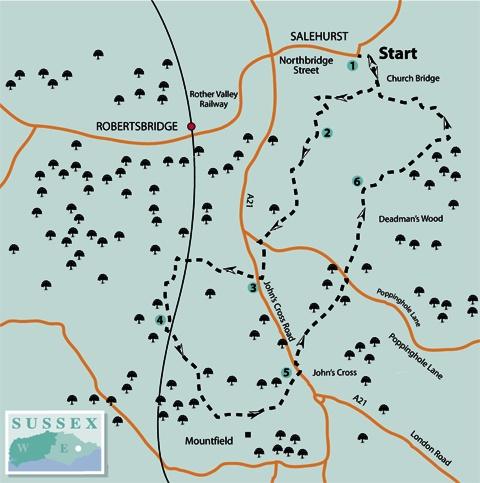
1 - Start the walk along an unmade track which leaves the road next to Salehurst Church and runs beside the churchyard wall before curving right. Follow this track across the River Rother and immediately go right over a stile and across a field to join a drive through a gate in the far corner. Turn right.
After about 250 yards, just short of a triple oast, turn sharp left along another drive. After 100 yards, turn right, still along a drive, with a large open-sided barn on your left. After another 100 yards, go through a gate and immediately fork left over a stile and along a tree-lined path.
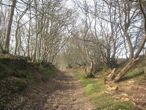
2 - After 100 yards, go over a stile beside a gate to enter Park Wood. A few yards inside the wood, fork right along a signed path. Ascend through this old coppiced woodland, ignoring crossing paths and disregarding a signed path to the right.
Shortly, leave the wood, turn left over a stile and follow a right field-edge with a fence and a row of young trees on your right. In the field corner, go over a stile beside a gate, forward along a track to another stile and gate, then ahead for 30 yards to a T-junction where you should turn right along a track, between high banks at first, following it out to a lane.
Continue along the drive to Midhurst Farm, opposite, which dwindles in turn to a track, then a path which takes you out to join the A21 road.
3 - Turn right and, after 60 yards, go left over a stile and head slightly right downhill across a field with an expansive view ahead, including a glimpse of the Darwell Reservoir. At the bottom of the field are two gateways. Go through the one on the left and turn right beside a right-hand hedge.
Go through a gap in the corner and continue along a right field-edge, with a ditch on your right. Go over a stile beside a gate about 30 yards to the left of the next field corner and head across low-lying rough pasture, possibly boggy in places.
Cross the railway and, at the bottom of the embankment on the other side, go left over a footbridge and immediately left, beside the railway perimeter fence, on your left.
Follow the left edge of two fields, walking roughly parallel to the railway, cross a stile, go left over a footbridge, half-right across a meadow to another footbridge and on through an area of mixed woodland and bracken.
4 - Leave the wood over a footbridge, go ahead for a few yards, then turn left beneath the railway. Go forward to cross a wide plank bridge and veer half-right up across parkland, passing to the right of scattered trees to find a stile. Continue uphill, passing immediately to the right of a tree-shrouded pond.
Climb more steeply to a gate, where a pause for breath allows you to look back across the valley. A track continues towards Mountfield Court, dating from 1715. Join a drive, skirt to the right of the building and, at a Y-junction, fork left.
Follow this ornamental drive, lined by an avenue of chestnut trees, many of them gnarled and ancient, out to the A21 opposite the John’s Cross pub, housed in a 500-year old building.
5 - Cross the road, turn left along the verge and, after a few yards, turn right along the second of two adjacent signed footpaths.
Pass through a metal swing-gate and go half-left across a field, passing through a gap in a skimpy hedge.
Go over a stile and follow a faint path across a sloping field to a stile in the far left corner. Maintain direction across the next field to a stile, also in the far left corner. Once over this stile, bear half-right across a field to join a lane to the left of two cottages.
Turn right and, after 40 yards, turn sharply back to the left across two fields with a stile between them, losing height. Over another stile in a dip, climb, passing to the right of a row of cottages. Join and go ahead along an unmade access drive with your final objective, Salehurst Church, in distant view ahead.
6 - At a T-junction, turn right and, at a second T-junction, turn right again, still on a hard track. Where the track ends at a cottage, go ahead beside a left-hand fence to a gate and continue with a wood on your right.
After about a quarter of a mile, join and bear left along another hard track. Follow a signed path diversion as it skirts to the left of a property. Join and turn left along a tarmac drive.
As you pass some houses, the remaining fragments of Robertsbridge Abbey can be glimpsed in a garden to the right. Founded in 1176, the Cistercian Abbey finally succumbed to the Dissolution in 1538.
After about a quarter of a mile, turn right along a signed bridleway and, shortly, recross the River Rother, rejoining your outgoing route and retracing your steps to the start.
The church has a solid square tower, partly dating from 1250 and inside is an altar from Robertsbridge Abbey. Almost next door, the Salehurst Halt pub serves food and real ale.
* If you would like a longer walk, this circuit can be combined, without overlap, with the walk, also starting and finishing at Salehurst, which was published in The Magazine on April 7. The walk description and map can be downloaded from The Argus website.
The essentials
* Distance/Time: Six and three quarter miles / three and a half hours
* By Car: Start from Salehurst, signposted eastwards from a roundabout on the A21 just north of Robertsbridge. Roadside parking is possible near the church at GR 749242
* By Public Transport: Bus from Hastings along the A21
* What’s underfoot: An undulating walk, mostly along good paths or tracks. Muddy in places
* Thirsty Work: Pubs at Salehurst, next to the start, and at John’s Cross (point 5)
* So you don’t get lost: The walk is on OS Explorer 124, except the short there-and-back section at the start for which you will need OS Explorer 136


Comments: Our rules
We want our comments to be a lively and valuable part of our community - a place where readers can debate and engage with the most important local issues. The ability to comment on our stories is a privilege, not a right, however, and that privilege may be withdrawn if it is abused or misused.
Please report any comments that break our rules.
Read the rules here