
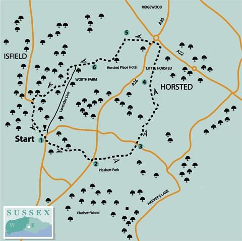
1 - From Isfield Station, cross the old level crossing, turn right and, after 60 yards, turn left along the drive to Farm Place, indicated as a public footpath with a stone plinth. After 100 yards, fork right along a path and, after less than 100 yards, go left over a stile and forward along the left edge of rough pasture.
Shortly sidestep to the left through a hedge gap and resume your previous direction along a right field-edge to a stile and plank bridge and on along the right edge of two fields.
Continue over a stile and between houses, turning right over another stile to follow a drive out to the A26 north of Rose Hill.
2 - Turn left and, after 60 yards, go right over a stile set back from the road to follow an uneven but attractive path within the right edge of a wooded strip, which looks as if it may once have been an old driveway.
The path runs along the top of a bank, vague in places, crossing two stiles en route. Keep park railings nearby on your right and you won’t go astray. After about a quarter of a mile, bear left along a hard track.
Where this track veers left, go ahead along a woodland path, soon ignoring another right fork. Shortly go left over a stile and across a field corner to join a lane over another stile.
3 - Go ahead along the drive, almost opposite. After about 300 yards, at a footpath finger post, fork left and, at a similar post, go ahead along a golfers’ path.
The route across the golf course from here is fairly liberally waymarked, but the signs are sometimes ambiguously orientated.
Shortly, at a waypost, bear right on a path which winds along within the right edge of an area of woodland. When opposite a pond on your right, veer right, aiming for the ornate club house. Cross a golfers’ bridge and turn left along a hard track which skirts to the left of another area of woodland.
After less than 100 yards, just short of another finger post, fork right, now along a sandy track. Cross a fairway to join and climb beside a left-hand hedge to a stile leading out to a lane on a bend.
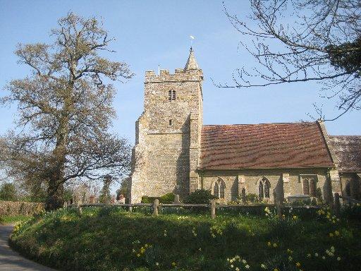
4 - Go ahead along a lane, passing Little Horsted School on your left. At the end of the lane, go ahead through a gate and forward in a straight line across more of the golf course, then ahead with a fence on your left, passing beneath power lines about 60 yards to the right of an electricity pylon.
In the field corner, turn left to follow a recently resurfaced bridleway out to the A26. Turn left and, after a few yards, go right along a lane, signed to Horsted Green.
5 - After about a quarter of a mile, turn left along a signed footpath, which starts through a hedge gap and follows a left field-edge, passing back under the power lines, this time about 50 yards to the left of a pylon.
Back on the golf course again, go ahead along a golfers’ tarmac path, meandering right and left. Where the path bends left again, go half-right, following waymarks to a plank bridge, from which your path continues along the left edge of a golf-playing area.
Shortly, at a waypost, turn left through trees to a stile and on along the left edge of a large fenced garden. Over another stile, turn right between fences and shortly go ahead along a house drive.
6 - A few yards after crossing a culverted stream, turn right over a stile set back from the road, go over a plank bridge and ahead, walking parallel to the right field-edge at first, then straight on across the field to a footbridge over the River Uck.
Go ahead, without change of direction, with the meandering stream nearby on your left. Pass, with the river, beneath the old railway at the present northern limit of the restored Lavender Line and carry on beside the river.
Go through two gates in quick succession and immediately fork left through a third gate, continuing along the left edge of a field, with the river still on your left. After about 250 yards, turn left over a substantial bridge across the river and immediately turn right with the river now on your right.
Where the enclosed path ends, go through a gap or the iron kissing gate beside it and turn left along a left field-edge, parting company with the Uck. After less than 100 yards, go through a gate and forward beside an electric paddock fence.
Cross a welded iron stile and go ahead along a farm track. Just short of a large shed, turn right along a drive. Follow the drive round to the left and immediately, when opposite a chicken house on your left, turn right, go through a wooden gate in a high fence and turn left along a house drive to join a lane. Turn left back to the start.
* The Lavender Line incorporates the restoration of Isfield Station and a mile of the old railway which, until 1969, linked Uckfield and Lewes. It is open on Sundays throughout the year and has special event days during the summer months.
* For more information, visit www.lavender-line.co.uk
The Essentials
* Distance/Time: Five and a quarter miles / two and a quarter hours
* By Car: Start from Isfield, signed westwards from the A26 between Lewes and Uckfield
* By Public Transport: Bus 29 from Brighton, Lewes or Uckfield to Isfield (hourly on weekdays), or joining the walk at Little Horsted, close to point 4 (half-hourly weekday service)
* What’s underfoot: Easy, level walking, mostly along well-marked paths or tracks. Some care with navigation needed where route crosses the East Sussex National Golf Course
* Thirsty Work: Laughing Fish pub at Isfield; Halfway House pub a short distance southwards along the A26 from point 2 at Rose Hill
* So you don’t get lost: OS Explorer Map 123


Comments: Our rules
We want our comments to be a lively and valuable part of our community - a place where readers can debate and engage with the most important local issues. The ability to comment on our stories is a privilege, not a right, however, and that privilege may be withdrawn if it is abused or misused.
Please report any comments that break our rules.
Read the rules here