
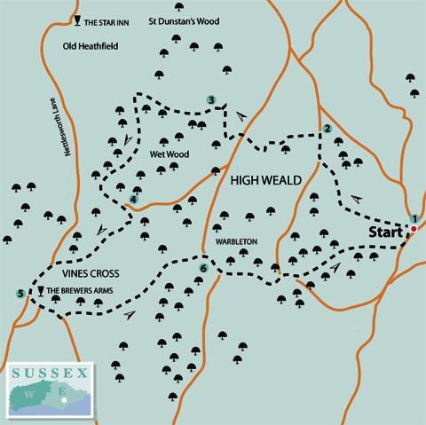
1 - Set out along a path, marked with a stone plinth, which starts from the road a few yards to the right of the Horse and Groom pub at Rushlake Green, passes along the edge of a garden, down to a stream crossing, up through woodland and then, unfenced, across a field.
Once through a gap into another field, fork half-right across the field where a path should be marked out through any growing crop. If in doubt, aim for the far corner and a barn in distant view beyond.
In the corner, go through a gap, maintain your previous direction across the next field to join a lane through a hedge gap and turn right.
2 - After about 200 yards, turn left through a gap into a field corner to the right of a barn and follow the left field edge downhill. From the bottom field corner, a path drops steeply down to a footbridge in a wooded dip.
Over the bridge, turn left to follow a path which winds up to leave the wood where you should join and follow a left field edge. After about 100 yards, follow a signed path left through a gap, along a right field edge for 60 yards, then right with a house and garden to your right.
Join the drive from the house and follow it out to a lane. Turn left and, after five yards only, go right over a stile and downhill along a right field edge with a good view southwards across the wooded Weald to the distant South Downs.
Drop down across this field to join a drive through a swing gate and turn right. At the bottom of the hill, just short of a gate, fork right to cross an elaborate new bridle bridge, ignoring a path off to the right from the bridge. Turn left to rejoin the drive and turn right.
3 - After about 60 yards, just short of a gate, turn left over a stile into woodland. Leave the wood over another stile, head squarely out across a field and slightly left across the next open area, a patchy mix of grass and bracken. A clear path continues downhill along the left edge of an area of scattered trees.
Towards the bottom of the hill, where the church at Old Heathfield comes into view through a gap in the trees ahead, turn sharply back to the left and climb, walking parallel to woodland a little way away to your right. At the top of the slope, pass to the right of a prominent oak tree, go through a gateway and continue with the wood now immediately on your right. Feed into an enclosed path and then a drive which takes you down to join a lane where you should turn left.
4 - Immediately after the lane crosses a stream, fork right over a stile and climb across a field to pass to the left of an electricity pylon.
A few yards past the pylon and just short of a gap taking the path ahead into scrub which you should ignore, turn right and drop downhill along the left field edge.
From the bottom corner a path winds through scrub to a footbridge. Over the bridge, turn left for a few yards to a stile and then follow a right field edge. After about 150 yards, go right through a gate and head diagonally across a field. In the corner, join and follow a concrete access drive out to a lane and turn left into Vine’s Cross.
5 - Just past the Brewer’s Arms pub on your left, turn left along Foords Lane. Disregard a right turn. Ignore the first signed path to the left and after another 20 yards, go left over a stile beside a gate and turn right round two sides of a field, behind the roadside hedge at first.
In the second field corner, go ahead through a gap and follow a well-trodden path over two fields to a footbridge, across a field corner on beside a right-hand hedge until you can side-step to the right through a gap and continue with the hedge now on your left.
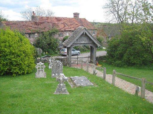
At a waypost, turn right along a cross-field path to enter Warbleton churchyard.
Walk through the churchyard, passing through a gap in a wall next to a memorial to Richard Woodman a local ironmaster, one of the ten Protestant martyrs burnt at the stake in Lewes in 1557.
6 - Exit through the main church lychgate and turn right past the Black Duck Inn. At a road junction, fork left and at a second junction after half a mile, fork right, both roads signed to Rushlake Green.
After about 150 yards, turn left along a signed path which you can follow unmistakeably, mostly within woodland, back to Rushlake Green within yards of the start.
- Distance/Time: Six and a quarter miles/three and a quarter hours
- By Car: Start from the village of Rushlake Green, signposted from the B2096 Heathfield-to-Battle road about two miles east of Heathfield. Roadside parking is possible in several places round the village green at GR 627184
- By Public Transport: None practicable
- What’s underfoot: Mostly along well-signed and used field and woodland paths, plus short stretches of quiet country lane. Minor ups and downs only
- Thirsty Work: Pubs at Rushlake Green, Vine’s Cross and Warbleton, all on the route
- So you don’t get lost: OS Explorer 123


Comments: Our rules
We want our comments to be a lively and valuable part of our community - a place where readers can debate and engage with the most important local issues. The ability to comment on our stories is a privilege, not a right, however, and that privilege may be withdrawn if it is abused or misused.
Please report any comments that break our rules.
Read the rules here