
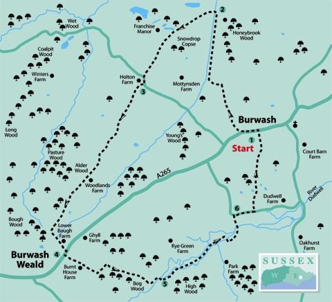
1. From the entrance to Burwash village car park, turn left along the village street. After about 150 yards, just short of the village hall, fork right along a drive, leaving the Catholic church and car park on your right.
Follow the drive downhill where, shortly, an expansive view opens out across the Rother valley. Where the drive ends, go ahead over a stile beside a gate and follow a wide, fenced path.
Where this path ends, go ahead over a footbridge and turn left downhill across pasture. Towards the bottom of the hill, go ahead through a gateway and, ignoring a footbridge ahead, turn right within a wide grassy strip to a gate and on in the same direction, walking parallel to the left field-edge. Over a footbridge, keep to the left of the next field as well.
2. After about 250 yards, turn left over a wide culvert, go ahead along a left field-edge to a gate and stile and continue, between hedges at first, then with a hedge on your left.
Go over a stile a few yards to the left of a gate and carry on in the same direction, joining and following a fence on your right enclosing the ornamental gardens of Franchise Manor.
Approaching the field corner, sidestep to the right over a stile and turn left, resuming your previous direction along the drive from the Manor. Shortly on your right is a simple memorial to an airman killed in action during the Second World War. Follow the drive out to a lane and bear left along it.
3. After about 50 yards, turn right along a signed bridleway, soon ignoring a signed path to the right. Follow this shady old trackway, full of atmosphere and character though likely to be muddy underfoot in places, for a mile and a half.
A few yards short of the point where the main track comes out into the open next to a barn, turn left along a path, partly between banks and signed as a bridleway, which takes you out via an access drive to join the A265.
4. Turn right and, after 30 yards, go left, passing between low concrete posts to join and follow another access drive. Follow the drive between houses at Burnt House Farm and, where the drive bends right towards the last house, go ahead through a gate and follow a left field-edge.
After 60 yards, go left through a swing gate, half-right across a paddock to a second swing gate and on along a left field-edge. Just short of a gate in the corner, bear half-right, staying within the same field and dropping down along a left field-edge.
Through a third swing gate in the field corner, a path drops down through Bog Wood towards the bottom of the hill, emerging to follow a right field-edge for a few yards before turning right to cross the River Dudwell.
5. Over the river, turn left, diverging gradually from the river to go through a gate and follow a left field-edge. After a little over 100 yards, sidestep to the left through a gate and resume your previous direction along the valley, now following the right edge of a meadow.
Feed into an enclosed path with the Dudwell nearby on your left. Disregard a path going left over a bridge. Skirt to the left of a pond and to the right of the Bateman’s water mill, which still sometimes grinds corn and at one time generated electricity for the mansion.
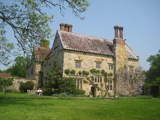
Join a drive and turn left to follow it out to a road junction next to the house and garden of Bateman’s, on your left. This magnificent stone house was built in 1634 for a local ironmaster but is better known as the home of Rudyard Kipling from 1902 to 1936. It is now looked after by the National Trust and is open during the summer months, except on Thursdays and Fridays.
6. To visit the house and garden, turn left at the road junction and left again to the car park and ticket office, but to complete the walk, on reaching the road junction, turn right. After about 200 yards, turn left over a stile and climb along a right field-edge. In the field corner, go through a wide gap and continue uphill, joining and following a left field-edge for a short distance and then continuing without change of direction up across a field.
In the top field corner, go over a stile and follow the left edge of three more fields on a trodden and signed path which brings you out into the corner of the car park, back at the start of the walk.
Allow time for a stroll along the village street. Burwash owed its early prosperity to the iron industry of the 15th to 17th centuries. The street is lined by many old and picturesque houses, notably Rampyndene, a well-preserved house dating from 1699.
The church has a Norman tower and contains more relics of the medieval iron industry, notably the oldest iron grave slab in Sussex, inscribed with the name of Jhone Collins, a local iron founder.
The essentials...
- Distance/Time: Five miles/two and a half hours
- By Car: Start from Burwash on the A265 east of Heathfield. Park in the village car park on the south side of the main road through the village at GR 673247
- By Public Transport: Scanty weekday bus service from Heathfield
- What’s underfoot: An undulating walk, mainly along well established paths and good tracks. May be muddy underfoot along Holton Lane between points 3 and 4
- Thirsty Work: Pubs and tea rooms at Burwash. None on the walk
- So you don’t get lost: OS Explorer Map 136


Comments: Our rules
We want our comments to be a lively and valuable part of our community - a place where readers can debate and engage with the most important local issues. The ability to comment on our stories is a privilege, not a right, however, and that privilege may be withdrawn if it is abused or misused.
Please report any comments that break our rules.
Read the rules here