
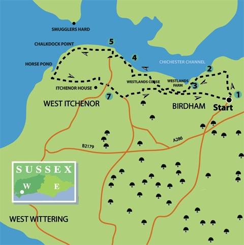
1 - From the triangular green at the junction of roads in Birdham, beside the village water pump and with the church behind hedgerow to the left, go right, northward, along Court Barn Lane, a quiet road and public footpath.
In a little over a quarter of a mile, having passed a short row of cottages, the road comes to a junction. Take the left turning along a driveway and footpath towards Harbour Meadow, passing side turnings on the right. Keep to the footpath and, at a fork in the drive, take the left branch, with hedgerow and trees on the right and a wide field on the left.
On coming to an enclosed section of path, beside a high brick wall on the left, walk ahead to a footpath close to the edge of the Chichester Channel.
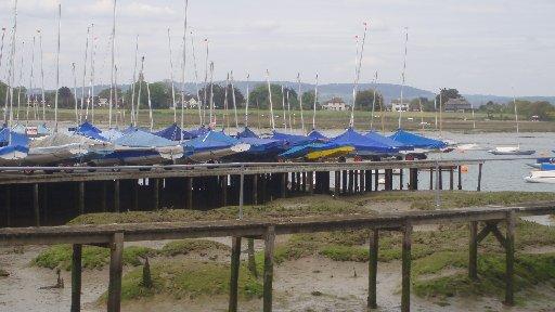
2 - Bear left along a path, passing a launching ramp and Westlands Pier, continuing at the foot of gardens and waterfront houses.
The busy inlet provides access to the large, upstream Chichester Marina, with a further mile and a half of waterway passing by Dell Quay to Fishbourne.
In 250 yards turn left, climbing an enclosed path, then go right for 150 yards through a residential area, turning left at the far end.
In 100 yards, at a minor road, turn right for about 75 yards and, when beside a house called Creek End, take the right footpath along a drive. Do not take the path going left.
3 - Walk along the drive and on coming to the entrance of Westlands Farm take a few paces left and pass through a bridle gate on the right. Do not take the left turning on the Salterns Way track. Keep direction to the end of the right hedgeline and fence in 100 yards.
Bear half-right at a path junction, at the end of the hedgeline and fencing, heading towards and passing through the edge of Westlands Copse.
At a bridle gate, turn left along a quiet residential road for a little over 300 yards and immediately after Harbour House turn right on an enclosed path to the edge of the channel.
4 - Turn left along the twists and turns of the raised footpath above jetties and moorings. On arriving beside the building of the West Itchenor Sailing Club, turn left for 150 yards to the main street of West Itchenor, arriving opposite The Ship Inn.
The village is a lively place with an active community that is increased by weekend visitors who come to sail from the moorings. There is a seasonal passenger ferry that operates from the quayside, crossing to Smugglers Hard near Bosham – perhaps a landing site for a long-past, nocturnal, local industry.
Turn right down the street to Itchenor Quay. The Chichester Harbour Conservancy Board information office is on the left.
Close to entrance of the information office is a memorial seat that remembers the 28 men of the Royal Marine 601 LCM flotilla who lost their lives on July 21, 1944, when returning from the Normandy beaches. Landing craft were used to ferry men and supplies across the English Channel following D Day and West Itchenor was one of the bases from which they operated. A moving ceremony is held annually by the local community in recognition of the contribution and sacrifice that was made by the supply ships.
5 - Turn left from the information office, between buildings and up a pebble ramp, passing maintenance sheds and a boatyard. The well-graded footpath now continues westward above the shoreline, with options to venture to the water’s edge in places. The Chichester Channel meanders off to the right as it heads further inland.
Off to the right, across the channel, is Cobnor Point and to the west is Thorney Island, a former RAF fighter squadron station during the Second World War and now an army base.
The path rounds Chalkdock Point and heads south-west for half a mile to arrive at a path junction close to a spit forming the feature known as Horse Pond. This is the return point for those who have arrived with a baby buggy, as from here on in the path is more difficult and there are stiles to cross – the return journey offers a pleasant and different view of the inlet.
6 - For walkers, turn left from the coastal route, through the squeeze stile that leads to a field-edge path. In 200 yards the path crosses a stile on the right and resumes direction along a rough track for a quarter of a mile, drawing alongside the grounds of Itchenor House, a former hunting lodge.
Continue along the path and, with farm buildings a short distance ahead, cross a stile on the right. Follow a wall-side path for 100 yards, take a few paces left, resuming direction, then take a left a turn along the metalled surfaced drive to a minor road.
7 - Walk ahead along the road (do not take the left turn), climbing to pass by West Itchenor church and bearing right along the roadside, to a left footpath turn, beside farm buildings, after a further 300 yards. The path passes beside a brick wall, crossing a footbridge to the edge of a wide field.
Follow the field-centre path for 400 yards, diverting left a few paces and resuming direction for a further 400 yards, beside a ditch, to a path junction we encountered earlier in the walk, close to Westlands Farm.
Continue ahead along the left fence and hedgeline; pass through the bridle gate, going left, then right, and resuming direction along the driveway to the minor road.
The final part of the route now follows the quiet roadside ahead, back to Birdham, arriving beside the church and village pump after half a mile.
- DISTANCE/TIME: Six and a half miles, taking three and a quarter hours; three and a half miles to point 6 for baby buggy walk, plus return, earlier return is an option.
- BY CAR: Birdham is south off the Stockbridge roundabout on the A27 Chichester bypass, follow A286 for three miles, turn right, west, on to Church Lane at Birdham, parking possible beside church. Start point grid ref SU824003.
- BY PUBLIC TRANSPORT: Travel details from www.traveline.info, phone 0871 2002233. Bus service from Chichester stops close to Russell’s Nursery on A286, walk back to Church Lane – follow to start, adds half a mile to walk.
- WHAT’S UNDERFOOT: Coastal plain walking on level paths with no climbs. Possible with a baby backpack all the way and with a baby buggy up to point 6.
- THIRSTY WORK: The Ship Inn at West Itchenor.
- SO YOU DON’T GET LOST: OS Explorer map 120 plus a compass for general direction.
Click here for a full-sized map of the Birdham and West Itchenor walk


Comments: Our rules
We want our comments to be a lively and valuable part of our community - a place where readers can debate and engage with the most important local issues. The ability to comment on our stories is a privilege, not a right, however, and that privilege may be withdrawn if it is abused or misused.
Please report any comments that break our rules.
Read the rules hereLast Updated:
Report this comment Cancel