
On a previous walk in this part of the county, we visited all four of the Marden villages and noted that three of them had churches and only one had a pub, but things may have been different in the past. On this occasion we visit the village of West Marden, the one with the pub and no church, heading out further west to isolated farming country.
Should the need for more spiritual sustenance be required on returning to our starting point, the weary walker can be assured that the other Marden villages, with churches, are not too far away and can be easily reached, once the walker’s inner hunger has been sated at the pub.
The term Marden, used by the four villages in this part of the county, would seem to indicate habitations or communities at a border or boundary area. The precise boundary between Sussex and Hampshire was for some time rather poorly defined, but the villages would have been markers to show that a change in county identity had taken place.
The walk is largely on level paths with some gentle woodland rise and fall. This is quiet agricultural countryside with large fields and well-tended woodland.
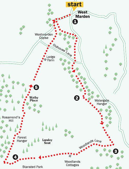
1. From the crossroads in West Marden, on the B2146 road, walk up the main street of the village, signposted to Rowland’s Castle, heading west and passing The Victoria Inn.
Climb between the flint buildings for 350 yards and, with the entrance to West Marden Hall off to the right, locate the stile and footpath sign on the left, just after the last house. Cross into the field and follow the left fence line for 150 yards to cross a stile and enter the woodland of West Marden Copse.
Follow the pleasant tree-covered path for several hundred yards to a point where it leaves the beech woods over a stile and turns right for a short distance. The path then re-enters the woods over a stile in 75 yards and climbs to the left to follow a southerly, wooded, balcony path that arrives at Oldhouse Lane in a little over a quarter-of-a-mile.
Cross the lane, going quarter- right on a bridleway, in a few yards cross over a drive, and follow a rising, southeasterly direction for nearly half-a-mile.
Finally, the bridleway turns to the right and then goes left for a few paces to arrive beside an isolated dwelling and a junction of tracks.
2. Locate the onward left field-edge bridleway that is across a drive, opposite the house, and follow this. The track keeps to the left edge of the huge field, with Watergate Hanger to the left.
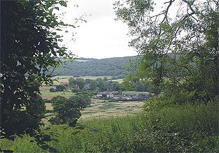
There are occasional glimpses through the trees to the surrounding countryside and a view to the left to the delightful settlement of Walderton. Across the field, to the right through distant trees, there are sightings of the Isle of Wight.
Continue on the bridleway, to be joined by a track from the left towards the end of the field and then a bridleway from the left as you finally approach Woodlands Lane, after three-quarters-of-a-mile.
3. Turn right up the quiet, metalled lane, which soon becomes a rougher, more level track.
Stride out for two-thirds of a mile to draw alongside Woodlands Cottages. Continue ahead for 150 yards, passing around double metal gates and arriving at a five-way footpath and bridleway junction.
Follow the bridleway ahead (blue arrow) in a westerly direction, with views across fields on the right to the secluded, classical facade of Lumley Seat.
Keep to the level path for a little over half-a-mile, with the estate grounds of Stansted Park becoming obvious on the left. The bridleway then arrives beside two very trimlooking flint-faced dwellings, known as Iron Gate Cottages, and a junction of tracks.
4. Turn left at the junction and walk down the access drive to come to a further junction, with the entrance to Stansted House on the left. The house was once the country estate of the Bessborough family but now, like many similar stately piles, is a visitor attraction with a wide range of events, exhibitions and re-enactments throughout the year.
Turn right down the metalled drive for 200 yards and, just after a speed hump in the drive (not noticeable if you are walking at the correct speed), turn right through a bridle gate (blue arrow).
The bridleway keeps to the edge of Forest Hanger, with prominent sweet chestnut trees, for half-a-mile. Finally the bridleway rises to the bushy cover of Rosamond’s Hill after three-quarters-of-a-mile of field-edge walking.
The path then turns left to enter the woodland for a few yards and a moist convergence of four tracks. Turn right on the bridleway option, taking neither of the footpaths leading left and right at this four-way junction.
Continue for a quarter-ofa- mile through Wythy Piece to come to the edge of the woodland.
5. Continue up the broad field, on a grassy track, towards the obvious buildings at Lodge Farm on the skyline.
Walk ahead between the farm buildings to a metal gate and continue on the bridleway.
The track drops after 300 yards to the metalled surface of Oldhouse Lane, which was encountered earlier.
Cross to the opposite side and locate the ongoing footpath.
Keep to the left field-edge, which may be overgrown at certain times of the year. The path drops to Westmarden Copse at the left field corner, after 350 yards.
Enter the copse (yellow arrow), turning to the left and descending to an enclosing field edge fence and stile in a short distance. The tiled roofs of West Marden become obvious on the right.
Climb over the stile into the small field we were in at the start of this walk and head for the lower left corner and stile.
Cross into the village street and turn right, back down the hill to the starting point.
- Distance/time: Five miles taking two-and-a-half hours.
- By car: West Marden is on the B2146, Westbourne to South Harting road, three miles south of Uppark House. Roadside parking in a lay-by. Start point Grid Ref. SU773136.
- By public transport: Details from www.traveline.info or phone 0871 2002233. Bus stop in the village.
- What's underfoot: Western Downs walking, on mainly level bridleways, with a few short, but easy climbs. Possible with a baby backpack. Not possible with a baby buggy.
- Thirsty work: The Victoria Inn at the start/finish point in West Marden village.
For a larger version of the map, see 'related links' above.


Comments: Our rules
We want our comments to be a lively and valuable part of our community - a place where readers can debate and engage with the most important local issues. The ability to comment on our stories is a privilege, not a right, however, and that privilege may be withdrawn if it is abused or misused.
Please report any comments that break our rules.
Read the rules here