
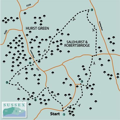
1 - Start the walk through the main entrance to Salehurst Church. Walk round behind the church and leave the churchyard through an iron kissing-gate. Now follow the left edge of two successive fields.
Join a track, turn right for five yards only, then go left through a hedge gap and along the left edge of another field, where a wide headland path has been preserved. Follow it round to the left, soon ignoring a signed path off to the right across a field.
Now care is needed. After about 150 yards, where the field edge begins to veer right, fork left along a narrow, unsigned and not very obvious path, which enters an area of trees and scrub.
Follow this path, overgrown and uneven underfoot in places, as it curves right and shortly, at a Y-junction, fork left, uphill, through more mature woodland, soon with a wire-mesh fence on your left and climbing steeply Over a stile, go left beside a post-and-rail fence, join a tarmac drive for a short distance, and then go left through a gate to follow a well way-marked path as it skirts to the left of the buildings at Higham House.
Join a drive, go right for a few yards then left through a gate, past a pond on your right, and through a garden to join a lane.
2 - Turn right and follow this quiet lane (Bourne Lane) for the best part of a mile. At a road junction, turn right and, after a little over 100 yards, turn left along the concrete drive to Bailey’s Green Farm.
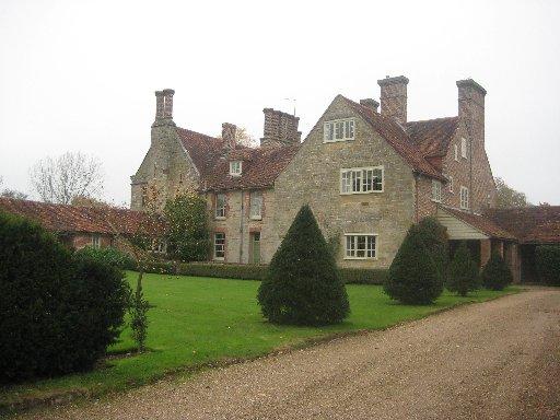
Pass between the buildings and, where the concrete ends, go ahead along a fenced unmade track. Just short of the buildings at Great Wigsell, ignore the first drive to the left and, after a few yards, go left along a gravel drive, passing to the left of the mansion.
This impressive stone-built house dates from about 1641 and was once the ancestral home of the Culpeper family.
Follow the drive round to the right, where you get a good view of the symmetrical house-front over to your right, and, after a few yards, turn left along a grass strip between high, trimmed ornamental hedges.
Go through a gate and, after less than 100 yards, fork right along a path which plunges into a thicket and climbs between tree-lined banks.
3 - After about half a mile, where the path comes out into the open at the bottom of a slope, turn left along the right lower edge of a sloping field, with a stream in the hedge on your right.
In the field corner, go ahead along a clear wide path and shortly, where it opens out into another field, go straight ahead across the field, aiming for a corner of woodland protruding into the field from the right.
On reaching this corner of woodland, go ahead with the wood on your right. In the next field corner, go forward through a belt of woodland and on in the same direction along an unfenced preserved path between two large fields, aiming for farm buildings (Little Iridge).
From a gate on the other side of the field, go ahead between houses and then turn left to follow an access drive from the houses out to the road at Silver Hill, next to a junction and within a few yards of the White Horse pub.
4 - Cross the unclassified Bodiam road and turn left beside the busy A21 where there is a narrow pavement. After a little over 100 yards go right over a stile, through a gap in a wall and along a path within a wooded strip, walking parallel to the drive to Ockham House on your left, skirting well to the right of the buildings.
After a little over half a mile, where the path opens out into an area of young planted trees, edge over to the right to join and follow a right-hand fence with a good view to your right across the Rother valley.
The path funnels down between banks to a junction with a hollow way, where you should turn right, downhill.
5 - After less than 100 yards, turn left through a squeeze stile and contour along a slope, crossing a track and continuing parallel to the right edge of two fields. In the second field, follow the field edge round to the left.
In the corner, go through a gap and, almost immediately, right through a thicket to a stile and over a brick bridge, then sidestep to the right, out into a field, and climb along the left field-edge.
The path soon levels out, high above the valley. Follow the left edge of two more fields. Towards the end of the third field, go left over a stile and forward along a drive, which takes you out to the A21.
6 - Cross the main road, turn right along the opposite verge and, after a few yards, go left over a stile, up across pasture to a gate, across a drive and another stile and then uphill, along the right edge of two fields with a short linking path between them, to join a lane. Turn right and follow this lane (Beech House Lane) for two-thirds of a mile back to Salehurst and the start.
* Distance/Time: Seven and half miles/three and a half hours
* By Car: Start from the village of Salehurst, east of Robertsbridge and signposted from the roundabout at the northern end of the Robertsbridge A21 bypass. Roadside parking is possible near Salehurst Church (GR: 749242).
* By Public Transport: Bus from Hastings, joining the walk at point six, north of Robertsbridge
* What’s underfoot: A gently undulating walk along field paths (possibly under cultivation and undefined in one or two places) and quiet lanes
* Thirsty Work: Pubs at Salehurst, next to the start point, and Silver Hill (point four)
* So you don’t get lost: OS Explorer Map 136


Comments: Our rules
We want our comments to be a lively and valuable part of our community - a place where readers can debate and engage with the most important local issues. The ability to comment on our stories is a privilege, not a right, however, and that privilege may be withdrawn if it is abused or misused.
Please report any comments that break our rules.
Read the rules here