
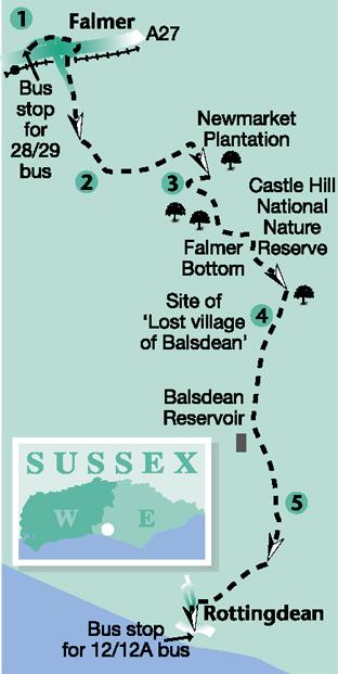
This linear downland walk by Ben Perkins is designed for bus users from Brighton, starting at Falmer and finishing at Rottingdean. En route, it traverses high open downland with superb views, passes through a national nature reserve at Castle Hill and close to the site of the ‘lost’ village of Balsdean.
1 - From the bus stop on the A27 at the start of the universities exit slip road, walk up beside the slip road. At the top of the slope go ahead across the road to the left of a roundabout and along the tarmac path opposite.
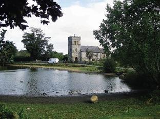
Join a road and bear right. Pass the Swan Inn on your left and turn right across a footbridge over the A27. On the other side of this bridge, turn right to join a road and follow it through Falmer village.
Shortly, at a road junction, go ahead, leaving the village pond on your left. At another junction, cross the road and go ahead through a bridle gate to follow a wide, recently established grassy headland path which climbs steadily along a right field-edge, soon with the Falmer-to- Woodingdean road behind the hedge on your right.
2 - After about two thirds of a mile, bear left through a gate to follow a signed bridleway which contours along the hillside with a fence on your left. After another two thirds of a mile you will reach the edge of Newmarket Plantation.
This tree clump was virtually destroyed in the Great Gale of 1987 but has been replanted and is now in good shape. A gate into the wood provides access to a circular route, well worth a brief detour.
To continue the walk, don’t enter the wood. Instead, in front of the gate into the plantation, turn right to a second gate and then climb along a right field-edge, now for a short distance on part of the South Downs Way. Towards the top of the hill, go through a gate and continue with a fence on your left.
A few yards short of the field corner, where the South Downs Way goes ahead, you should turn sharply back to the right along an unfenced track.
3 - After 250 yards, turn left through a bridle gate, passing a notice indicating that you are now entering the Castle Hill national nature reserve, an increasingly rare example of unimproved chalk grassland. Protected from ploughing and free from fertilisers, it is home to a number of rare plant and insect species.
Follow a clear track through the reserve, dropping downhill to follow the floor of a beautiful downland combe.
At a path junction, go through a bridle gate next to another nature reserve notice and turn left along the floor of Falmer Bottom.
Through another gate, go ahead, passing to the left of a cluster of barns. To the right of the track, beyond the barns, is the site of the “lost” village of Balsdean.
On record since the 12th Century, the village incorporated an 18th- century farmhouse and a Norman Chapel. It was occupied until the start of the Second World War but was then destroyed during Army training exercises.
4 - At a junction of paths within a group of scattered trees, fork right and, after 40 yards, at a waypost, fork left, following the direction of the only yellow arrow on the post. Climb fairly steeply along a faint path, and, when it comes into view, aim for another waypost on the skyline.
Go over a crossing path, forward for a few yards to a stile and on along the hillside where the path may be undefined and at risk from ploughing and planting. If in doubt, aim for a covered reservoir on the skyline.
After about 200 yards, on reaching an acute-angled junction of fences, side-step to the left across an overgrown stile and resume your previous direction, now with a fence on your right and still aiming for the reservoir.
Where this fence turns away to the right, go ahead, passing a few yards to the left of a wooden power pole and on to reach another waypost where you should veer half-left towards the field corner.
Cross an access drive using two bridle gates and bear half-right on a faintly trodden path across a field. At the far end of the field, go through a wooden bridle gate, ignoring two nearby metal farm gates, and keep to the right edge of the next field, now heading for the sea.
5 - Through another gate, with Rottingdean now in view ahead, veer half-left along the left edge of a sloping pasture, feeding into a more solidly-based track which passes to the left of a series of small paddocks.
At the edge of the built-up area, join an estate road and turn right and, after a few yards, go forward along a gravel track which takes you down into Rottingdean.
To see the best of the village, turn right where the house once occupied by Rudyard Kipling faces on to the village green and pond. The church is notable for stained-glass made by William Morris from designs of the artist, Sir Edward Burne-Jones, who also lived in Rottingdean.
To complete the walk, turn left and follow the High Street out to the seafront and the bus stop for buses back into Brighton.
* Distance/Time: Six-and-a-half miles/three-and-a-half hours * By Car: Not recommended. Parking is difficult at Falmer so park at Rottingdean (GR 372021), bus into Brighton and out to Falmer.
* By Public Transport: No 28 or 29 bus from Brighton to Falmer, alighting at the start of the Universities slip road. Bus No 12 along the coast road from Rottingdean into Brighton from the end of the walk.
* What’s underfoot: Excellent walking along good paths and tracks except, possibly, beyond point 4 where the path may be obliterated by ploughing. Fairly hilly terrain.
* Thirsty Work: Swan Inn at Falmer. Choice of pubs and tea rooms in Rottingdean * So you don’t get lost: OS Explorer 122.


Comments: Our rules
We want our comments to be a lively and valuable part of our community - a place where readers can debate and engage with the most important local issues. The ability to comment on our stories is a privilege, not a right, however, and that privilege may be withdrawn if it is abused or misused.
Please report any comments that break our rules.
Read the rules hereLast Updated:
Report this comment Cancel