
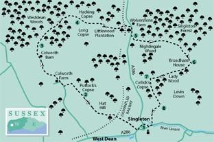
1 - From the centre of the village, beside a bridge over a stream and the local tearooms, turn left along the main A286 road, passing a bus stop and local houses. At a bend in the road, opposite a prominent weeping willow tree, cross with care to a signed footpath beside a stream with houses on the right. In a few yards pass through a gate on the left and walk around the edge of the cricket pitch, passing to the right behind the large wooden pavilion to cross a stile. Walk along a right hedgeline for a few yards and then go right over a second stile, diverting to cross a plank bridge. Go right to a five-bar gate and a National Trust sign for the Drovers Estate, cross a stile on the left and climb the public footpath (yellow arrow) up through a shrub tunnel. Pass over a bridge above a former railway and climb steps to a cross a field-edge stile. Climb steeply up the field, keeping generally to the left hedgerow for one-third-of-a-mile. At the top of the rise continue over the hilltop meadow of Hat Hill to the left field corner.
2 - Go left over a stile and then turn right on an enclosed path with Puttock’s Copse on the right. Pass through a midway stand of trees, continuing on the wider path to the end of the field. Descend a bank and turn left. At a minor road turn right, beside cottages, heading for Colworth Farm. Where the farm drive turns left, amongst barns, continue ahead on the winding bridleway towards the isolated flint cottages at Colworth Barn.
The bridleway diverts half-right and climbs to a track junction and clearing in 300 yards.
3 - Turn right on the bridleway into Westdean Woods, taking the right fork (blue arrow). In a quarter-of-a-mile pass over a crossing track, going to the left of a charcoal burner’s encampment. Continue climbing through the managed woodland, getting steeper as it approaches a junction of forest tracks, in a clearing, after one-third- of-a-mile. Turn right on a wide track for 100 yards and then divert right (blue arrow) onto a narrower bridleway.
4 - Follow the winding, east-bound bridleway between Hacking Copse and Long Copse. The woodland merges with Littlewood Plantation after half-a-mile, passing over crossing tracks and, in nearly a further half-mile, crosses over a concrete bridge, with the former railway track below in a very deep cutting. At the far side of the bridge turn right onto a descending, woodland bridleway (blue arrow). The path comes to the busy roadside, with Wolverstone Farm opposite. Turn right along the grass verge, crossing at a safe point and with great care, then continue south.
5 - After 300 yards go left onto a bridleway, on a wide surfaced driveway that is part of a service road for a local oilfield. Climb the metalled surface for 50 yards then turn left (blue arrow), climbing through woodland to re-join the service road in 200 yards.Turn left for a few yards and then go right, leaving the track, to enter Nightingale Wood (blue arrow). Climb through the woods, steep in places, descending to a small clearing in a hollow after a quarter-of-a-mile. With a track coming from the right, continue on the main bridleway, climbing slightly left. The path levels-off across the top of the wooded hill, with distant views down the Lavant valley, off to the right. In 400 yards the bridleway takes a half-right turn, descending to a crossing track in a further 150 yards. Turn left, taking a sweeping right turn, between hedgerow, to a four-way junction of tracks and paths, close to Broadham House.
6 - Turn right (yellow arrow) onto a footpath that passes beside farm buildings and the farmhouse (note the advisory sign about keeping dogs on a lead). Go through a gate beside a cattle grid and follow the farm drive along the valley bottom. As the drive rises to a second cattle grid and access gate, continue south-westerly beside Lady Wood and then begin a slow descent, passing Drovers Park Cottage after a quarter-of-a-mile. Follow the drive, turning right for a few yards and then take the stile on the left (yellow arrow) onto an enclosed path. Follow the path for 200 yards and, with an ornamental metal gate ahead, turn left over a stile.
7 - Climb steeply through woodland, crossing over a track in 75 yards. Continue the ascent and in a further 75 yards arrive beside some large, hilltop Beech trees. Head for a stile that is a few yards away and cross into a meadow.
Take a half-left line across the meadow, making for the edge of Collick’s Copse and pass right through a metal gate. Descend, keeping generally to the edge of the field, with the copse on the right. The path passes over a rise, beside a footpath sign at the edge of the copse.
The path finally leaves the edge of the copse and climbs to a four-way sign on the skyline at Levin Down.
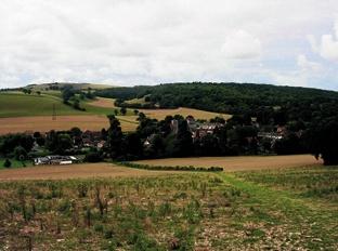
8 - Turn right down the hillside for 200 yards and, when beside a clump of hawthorn bushes, turn left (obscured path sign on the right). Head for the wooden kissing gate and pass through for a delightful view across the rooftops of Singleton village. A thoughtfully-placed seat on the left offers a pleasing spot to take in the scene. Continue down the hillside, passing left of a small cemetery with a distinctive lychgate.
In a few yards arrive beside the valley road, with the village school on the left. Turn right along the road, passing between the houses of the village and arriving back at the starting point, conveniently close to the teashop and pub.
* Distance/Time: Seven-and-a-half miles, taking three-and-three-quarter hours.
* By Car: Roadside parking in Singleton village. Start point Grid Ref. SU877132.
* By Public Transport: Bus details from www.traveline.info, phone 0871 200 22 33. Bus stop close to start point on the A286 road in Singleton village.
* What’s underfoot: Long climbs and descents, slippery in places after rain. Woodland and open hillsides. Possible with a baby backpack. Not possible with a baby buggy.
* Thirsty Work: Singleton Tearooms and The Partridge pub in Singleton.
* So you don’t get lost: OS Explorer map 120, plus a compass for general direction


Comments: Our rules
We want our comments to be a lively and valuable part of our community - a place where readers can debate and engage with the most important local issues. The ability to comment on our stories is a privilege, not a right, however, and that privilege may be withdrawn if it is abused or misused.
Please report any comments that break our rules.
Read the rules hereLast Updated:
Report this comment Cancel